Weather
55 Below Zero Wind Chill: Extreme Cold Moves Into IL
The coldest wind chills will range from 40 to 55 below zero Wednesday and Thursday mornings.

Extreme cold impact the region Tuesday through Thursday. Some of the coldest temperatures will be Tuesday night and Wednesday night, when temps will be -20 to -30, the National Weather Service said. On Wednesday, temperatures will remain below zero and will struggle to get above zero on Thursday as well.
The NWS said the coldest wind chills will range from 40 to 55 below zero Wednesday and Thursday mornings. A wind chill warning will go into effect 6 p.m. Tuesday to 12 p.m. Thursday. There is also a wind chill advisory from 4 a.m. to 6 p.m. on Tuesday.
The temperatures in Chicago on Wednesday will be lower than Dome Fuji in Antarctica (37 degrees), Mount Everest (3 degrees), and Nome, Alaska (18 degrees).
Find out what's happening in Lemontfor free with the latest updates from Patch.
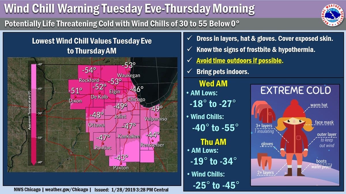
The NWS recommends dressing in layers with hats and gloves. Exposed skin should be cover. Bring pets indoors and avoid time outdoors if possible. The cold wind chills could cause frostbite on exposed skin in as little as five minutes.
Several communities have offered advice for heating your home during the cold temperatures.
Find out what's happening in Lemontfor free with the latest updates from Patch.
- Raise the temperature in your home to 2 to 4 degrees above your normal setting.
- Take all programmable thermostats out of setback mode and set on a permanent hold.
- If you have a furnace; replace the filter.
- Keep garage doors closed.
- Limit opening exterior doors.
- Make sure air vents and radiators are not blocked or obstructed.
- To help minimize temperature loss you can boil water, make soup, or stews; they help introduce humidity and warmer temperatures into your home. You should not use your oven or a grill to heat your home.
Image by Patch.
Get more local news delivered straight to your inbox. Sign up for free Patch newsletters and alerts.