Weather
6 Inches Of Snow: Winter Storm Approaches Chicago Area
A winter storm will move into the area Tuesday, and 6 inches of snow is possible, especially north of Chicago.


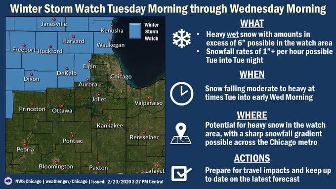
ILLINOIS — After a taste of spring this weekend, winter will return with vengeance this week. A winter storm is set to move into the area Tuesday through Wednesday morning, and several counties are under a winter storm watch, according to the National Weather Service.
Rain will start Monday, which has a high of 42 degrees, before the rain switches over to snow Monday night into Tuesday.
The weather service said heavy, wet snow with amounts in excess of 6 inches is possible Tuesday. Snowfall rates of 1 inch per hour are also possible Tuesday into Tuesday night. Areas to the north are expected to receive the most snow, with a sharp snowfall gradient possible across the Chicago area.
Find out what's happening in Lemontfor free with the latest updates from Patch.
The weather service said there is an 83 percent chance Waukegan will receive 2 inches of snow or more; a 43 percent chance for Aurora; a 19 percent chance for Midway; and a 17 percent chance for Joliet.
Thursday will be dry and partly sunny with a high of 27 degrees, the weather service said. Friday will be similar with a high of 26 degrees.
Find out what's happening in Lemontfor free with the latest updates from Patch.
Here is a more detailed look at the weather this week:
MONDAY: Rain, mainly after 3 p.m. High near 39. Northeast wind 5 to 15 mph, with gusts as high as 20 mph. Chance of precipitation is 90 percent. New precipitation amounts between a tenth and quarter of an inch possible.
MONDAY NIGHT: Rain before 8 p.m., then rain and snow between 8 p.m. and 2 a.m., then snow after 2 a.m. Low around 33. Northeast wind around 15 mph, with gusts as high as 25 mph. Chance of precipitation is 90 percent. New snow accumulation of less than a half inch possible.
TUESDAY: Snow. High near 35. Northeast wind 10 to 15 mph, with gusts as high as 25 mph. Chance of precipitation is 100 percent. New snow accumulation of 1 to 2 inches possible.
TUESDAY NIGHT: Snow. Low around 27. Blustery, with a north northeast wind 10 to 20 mph, with gusts as high as 25 mph. Chance of precipitation is 90 percent.
WEDNESDAY: Snow. High near 29. Blustery. Chance of precipitation is 80 percent.
WEDNESDAY NIGHT: A 20 percent chance of snow before midnight. Cloudy, with a low around 15.
THURSDAY: Partly sunny, with a high near 22.
THURSDAY NIGHT: Mostly cloudy, with a low around 11.
FRIDAY: Mostly sunny, with a high near 24.
FRIDAY NIGHT: Mostly cloudy, with a low around 10.
Get more local news delivered straight to your inbox. Sign up for free Patch newsletters and alerts.