Weather
78-Degree Warm-Up; Mild Temps On The Way
This weekend will feature some rain and much more mild temperatures.


After days of snow and below zero temperatures, we will begin to thaw out this weekend. Temperatures are expected to rise up to the mid-40s by Sunday, although rain is expected. The National Weather Service said low clouds and fog are expected to develop on Saturday, with the potential for rain.
There is a potential for freezing drizzle on Saturday, because while air temperatures will rise above freezing, cold ground due to recent sub-zero weather and a deep snow pack in some areas will result in freezing rain, according to the NWS. There is also the potential for ice jams and rising rivers early next week due to the melting snow and rain.
During the recent cold blast, Chicago got down to -23 degrees, and there is a forecasted high of 55 degrees for Monday, according to the NWS. That will be a 78-degree temperature difference in a matter of days.
Find out what's happening in Lemontfor free with the latest updates from Patch.
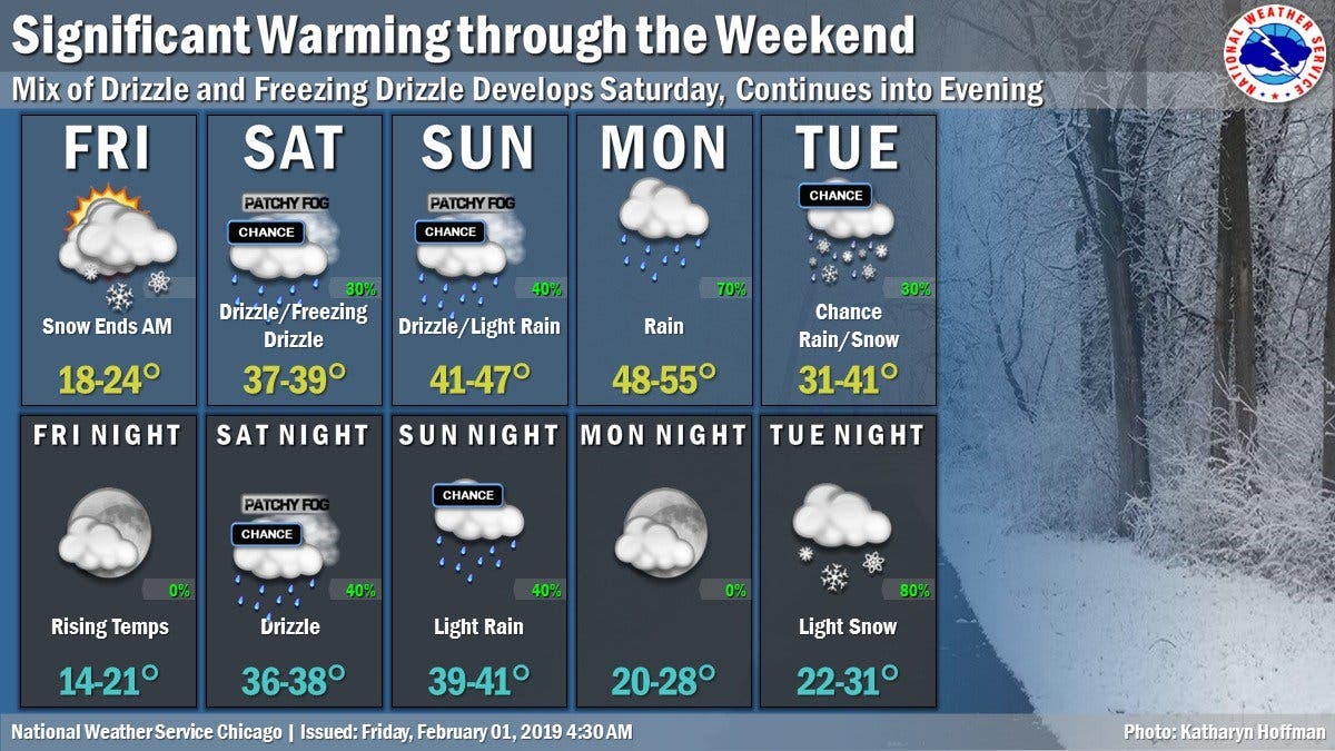
Here is a more detailed look at your weather this weekend:
- FRIDAY NIGHT: Partly cloudy, with a temperature rising to around 26 by 5 a.m. South southeast wind 5 to 10 mph.
- SATURDAY: A chance of drizzle or freezing drizzle between noon and 3 p.m., then a chance of drizzle after 3 p.m. Patchy fog after noon. Otherwise, mostly cloudy, with a high near 38. Southwest wind 10 to 15 mph.
- SATURDAY NIGHT: A chance of drizzle. Patchy fog. Otherwise, cloudy, with a low around 37. South wind 10 to 15 mph.
- SUNDAY: A chance of drizzle, mainly before noon. Patchy fog. Otherwise, cloudy, with a high near 45. South southwest wind around 10 mph, with gusts as high as 15 mph.
- SUNDAY NIGHT: A 30 percent chance of rain, mainly after midnight. Mostly cloudy, with a low around 39.
Image by Patch.
Find out what's happening in Lemontfor free with the latest updates from Patch.
Get more local news delivered straight to your inbox. Sign up for free Patch newsletters and alerts.

