Weather
90s Expected Most Of Week, Chance Of Storms For IL
The hottest day of the week will be Wednesday, which has an expected high of 96 degrees.


ILLINOIS — After some possible storms Sunday, temperatures will heat up this week, and will stay in the 90s through Thursday. According to the National Weather Service, there is a limited excessive heat risk on Monday, Tuesday, Wednesday and Thursday.
The highs for the week will be 93 on Monday, 94 on Tuesday, 96 on Wednesday and 94 on Thursday. According to the weather service, this hot air mass is not expected to be "oppressively humid."
Storms are also possible Monday night into Tuesday morning for far northern Illinois, the weather service said. There is also a chance of storms on Thursday night and Friday, when the high is in the 80s for the first time all week.
Find out what's happening in Lemontfor free with the latest updates from Patch.
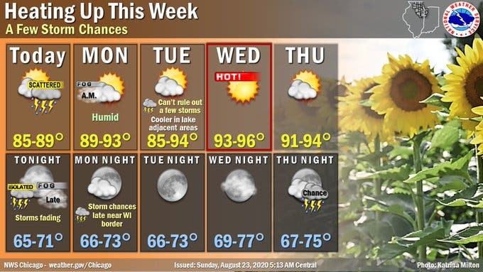
Here is a more detailed look at the weather for this week, with a forecast from the National Weather Service:
MONDAY: Sunny, with a high near 92. Heat index values as high as 95. West southwest wind around 5 mph.
Find out what's happening in Lemontfor free with the latest updates from Patch.
MONDAY NIGHT: Mostly clear, with a low around 69. South southwest wind around 5 mph.
TUESDAY: Sunny, with a high near 93. Calm wind becoming southwest around 5 mph in the morning. Winds could gust as high as 15 mph.
TUESDAY NIGHT: Clear, with a low around 70.
WEDNESDAY: Sunny and hot, with a high near 95.
WEDNESDAY NIGHT: Mostly clear, with a low around 73.
THURSDAY: A slight chance of showers and thunderstorms after 1 p.m. Mostly sunny, with a high near 92.
THURSDAY NIGHT: A chance of showers and thunderstorms, mainly before 1am. Partly cloudy, with a low around 70.
FRIDAY: A chance of showers and thunderstorms. Partly sunny, with a high near 86.
FRIDAY NIGHT: A chance of showers and thunderstorms. Mostly cloudy, with a low around 63.
Get more local news delivered straight to your inbox. Sign up for free Patch newsletters and alerts.