Weather
Storms, Flooding Possible: Illinois Weekend Weather
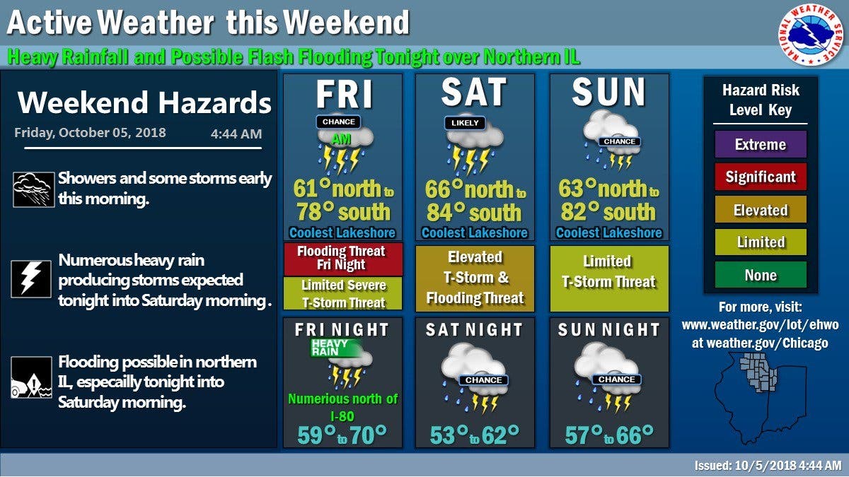
There are concerns for severe storms and possible flooding this weekend.


It will be an active weather week ahead with concerns of flooding and severe storms. According to the NWS, there is a significant thunderstorm risk on Friday. Thunderstorms are expected to develop and increase in coverage across northern Illinois on Friday evening.
The NWS said the movement of these storms may result in locally significant rainfall amounts of 2 to 4 inches, which could lead to flash flooding in some areas. The highest threat for this on Friday night will be primarily along and north of I-80.
Saturday has a limited flooding risk and an elevated thunderstorm risk, while Sunday has a limited thunderstorm threat. The NWS said thunderstorms producing heavy rain are likely through the middle of the work week.
Find out what's happening in Lemontfor free with the latest updates from Patch.
River flooding with significant flooding could be a concern this weekend, the NWS said. There are numerous waves of rain expected through the weekend across the upper Midwest including the Rock, Fox, DuPage, Des Plaines, and Calumet River basins in northern Illinois and southern Wisconsin.
1 to 3 inches of rain is likely by Sunday morning, according to the NWS. This rainfall is likely to cause rises on the Rock River, Fox and Des Plaines River basins.
Find out what's happening in Lemontfor free with the latest updates from Patch.

Here is a more detailed look at the weather this Columbus Day Weekend:
- FRIDAY NIGHT: Showers and thunderstorms, mainly after 10 p.m. Some of the storms could produce heavy rain. Temperature rising to around 68 by 4 a.m. Light south wind becoming south southwest 10 to 15 mph in the evening.
- SATURDAY: Chance of precipitation is 90%. New rainfall amounts between three quarters and one inch possible.A 50 percent chance of showers and thunderstorms. Some of the storms could produce heavy rain. Mostly cloudy, with a high near 74. South southwest wind 10 to 15 mph becoming north northwest 5 to 10 mph in the afternoon. Winds could gust as high as 20 mph.
- SATURDAY NIGHT: Showers likely and possibly a thunderstorm. Cloudy, with a low around 58. North northeast wind around 5 mph. Chance of precipitation is 70%.
- SUNDAY: Showers likely and possibly a thunderstorm before 1 p.m., then a chance of showers and thunderstorms after 1 p.m. Cloudy, with a high near 70. East northeast wind 5 to 10 mph. Chance of precipitation is 60%.
- SUNDAY NIGHT: Showers likely and possibly a thunderstorm. Cloudy, with a low around 62. Chance of precipitation is 60%.
- MONDAY: A 30 percent chance of showers and thunderstorms before 1 p.m. Mostly cloudy, with a high near 82.
- MONDAY NIGHT: Partly cloudy, with a low around 66.
Get more local news delivered straight to your inbox. Sign up for free Patch newsletters and alerts.

