Weather
Chance Of Snow, Cooler Temps Expected: IL Weekend Weather
Temps will be in the upper 30s and lower 40s this weekend, and there is a chance for snow Sunday.


ILLINOIS — After recent days of mild temperatures, some cooler temps and possibly some snow is expected this weekend. The National Weather Service said there is a chance of flurries Friday night and gusts could get up to 20 mph.
Saturday will have a high of 40 degrees, and should dry and partly sunny. According to the weather service, Sunday will be slightly warmer with a high of 44 degrees, and there is a chance of precipitation throughout the day.
Rain is possible Sunday afternoon, followed by a chance of rain and snow Sunday evening, and a chance of snow late Sunday night.
Find out what's happening in Lemontfor free with the latest updates from Patch.
After the weekend, temperatures will rise back up to the 50s, although there is some rain in the forecast next week.
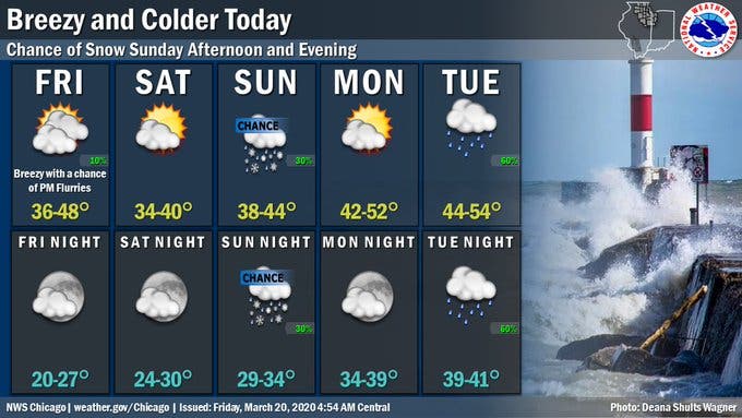
Here is a look at the weather for this weekend, with a forecast from the National Weather Service:
Find out what's happening in Lemontfor free with the latest updates from Patch.
- FRIDAY NIGHT: A slight chance of snow showers between 7 p.m. and 9 p.m. Mostly cloudy, with a low around 26. North northeast wind around 10 mph, with gusts as high as 25 mph. Chance of precipitation is 20 percent.
- SATURDAY: Mostly sunny, with a high near 37. Northeast wind 5 to 10 mph.
- SATURDAY NIGHT: Partly cloudy, with a low around 27. East northeast wind around 5 mph.
- SUNDAY: A 30 percent chance of rain after 1 p.m. Mostly cloudy, with a high near 43. East southeast wind around 5 mph, with gusts as high as 15 mph.
- SUNDAY NIGHT: A chance of rain and snow before midnight, then a chance of snow between midnight and 1 a.m. Mostly cloudy, with a low around 31. Chance of precipitation is 30 percent.
Get more local news delivered straight to your inbox. Sign up for free Patch newsletters and alerts.