Weather
Subzero Windchill Shifts To Mild Temps, More Snow: IL Weather
Snow is possible later in the week and milder temperatures will return Wednesday as well. Ice jams are a risk of thawing rivers.


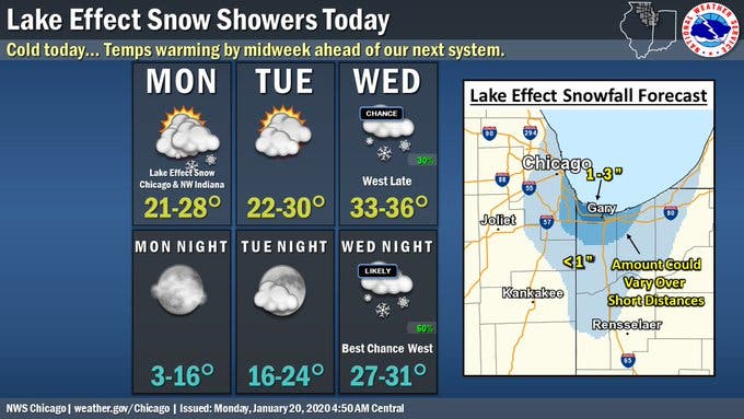
ILLINOIS — The colder temperatures and below-zero windchill will soon yield way to milder temperatures and some snow later this week. Tuesday will have a high of 30 degrees, the National Weather Service said, and it should be sunny and dry.
Wednesday will be even warmer with a high of 36, and it will be mostly cloudy during the day. According to the weather service, snow is possible late Wednesday and early Thursday. Thursday has an expected high of 37, and snow and rain are possible the entire day Thursday.
The weather service said snow and rain are also likely Friday, which will have a high of 37 degrees.
Find out what's happening in Lemontfor free with the latest updates from Patch.
Ice jams are also possible this week, especially for the Rock, Fox, DuPage, Des Plaines and Kankakee rivers. The weather service said the well below freezing temperatures have caused rapid river ice formation. Ice jams may cause rises on area rivers with little warning.
Here's a more detailed look at the forecast for this week:
Find out what's happening in Lemontfor free with the latest updates from Patch.
MONDAY: Scattered flurries before 5 p.m. Partly sunny, with a high near 27. Northwest wind around 5 mph.
MONDAY NIGHT: Partly cloudy, with a low around 11. North northwest wind around 5 mph.
TUESDAY: Sunny, with a high near 28. West southwest wind 5 to 10 mph.
TUESDAY NIGHT: Increasing clouds, with a low around 22. South southwest wind 5 to 10 mph, with gusts as high as 15 mph.
WEDNESDAY: Mostly cloudy, with a high near 35. South wind 10 to 15 mph, with gusts as high as 20 mph.
WEDNESDAY NIGHT: A 30 percent chance of snow after midnight. Cloudy, with a low around 30.
THURSDAY: A chance of snow before 11 a.m., then a chance of rain and snow. Cloudy, with a high near 37. Chance of precipitation is 40 percent.
THURSDAY NIGHT: A chance of rain and snow before 11 p.m., then snow likely. Cloudy, with a low around 32.
FRIDAY: Snow likely before 8 a.m., then rain and snow likely. Cloudy, with a high near 37.
FRIDAY NIGHT: Rain and snow likely before 5 a.m., then a chance of snow. Cloudy, with a low around 33.
Get more local news delivered straight to your inbox. Sign up for free Patch newsletters and alerts.