Weather
Chance Of White Christmas Dwindling, Dry Week Ahead: IL Weather
With the lack of snowfall and more mild temperatures, the chances of a white Christmas for the Chicago area are dwindling, the NWS said.

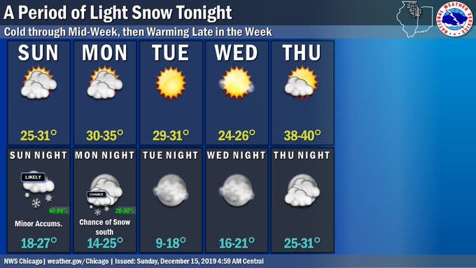
ILLINOIS — The work week will once again be mostly dry and sunny. Some light snow is possible Sunday night into early Monday, and some flurries are possible again Monday night south of I-80, the National Weather Service said. No major accumulation is expected with this snowfall.
Monday and Tuesday will both be dry during the day with temps in the 30s, the weather service said. Temperatures will dip to their coldest of the week Wednesday, which will have a high of 26.
Thursday and Friday will be warmer, with a high of 40 on Thursday and a high of 39 on Friday.
Find out what's happening in Lemontfor free with the latest updates from Patch.
With the lack of snowfall and more mild temperatures, the chances of a white Christmas for the Chicago area are dwindling, the weather service said. The 14-day outlook shows a high chance of above average temperatures in the days leading up to Christmas.
Here is a more detailed look at the weather this week:
Find out what's happening in Lemontfor free with the latest updates from Patch.
- MONDAY: Mostly cloudy, with a high near 33. North northeast wind around 5 mph.
- MONDAY NIGHT: Cloudy, then gradually becoming partly cloudy, with a low around 18. Northwest wind around 5 mph, with gusts as high as 10 mph.
- TUESDAY: Sunny, with a high near 29. West wind 5 to 10 mph, with gusts as high as 20 mph.
- TUESDAY NIGHT: Mostly clear, with a low around 12.
- WEDNESDAY: Sunny, with a high near 25.
- WEDNESDAY NIGHT: Mostly clear, with a low around 19.
- THURSDAY: Mostly sunny, with a high near 38.
- THURSDAY NIGHT: Mostly cloudy, with a low around 27.
- FRIDAY: Mostly cloudy, with a high near 39.
- FRIDAY NIGHT: Mostly cloudy, with a low around 27.
Get more local news delivered straight to your inbox. Sign up for free Patch newsletters and alerts.