Weather
Dry, Cooler Than Average Week Ahead: Illinois Weather
After a weekend of active weather, the week ahead looks dry and cooler than usual.

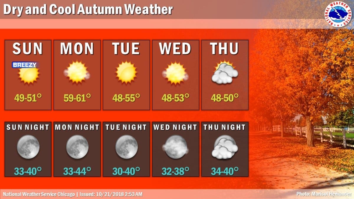
After a weekend of freezing temperatures, gusty winds and even some flurries, a dry, cooler than average week is expected. According to the National Weather Service, peak wind gusts at both O'Hare and Rockford were 61 mph on Saturday. There was also numerous snow showers across the area, and the NWS said this brought near white-out conditions near Romeoville around 2 p.m.
The week ahead will be more mild, and Monday will be the warmest day with a high of 61 degrees. There isn't a chance of precipitation and the week should be dry, the NWS said.
Temps are still cooler than average, and Tuesday, Wednesday and Thursday will all be sunny and have highs in the 50s. Friday will be mostly cloudy and has a high of 51 degrees, according to the NWS.
Find out what's happening in Lemontfor free with the latest updates from Patch.
Here is a look at your weather for this week:
- MONDAY: Sunny, with a high near 59. Southwest wind around 10 mph, with gusts as high as 15 mph.
- MONDAY NIGHT: Clear, with a low around 37. West wind around 5 mph.
- TUESDAY: Sunny, with a high near 51. North northwest wind 5 to 10 mph.
- TUESDAY NIGHT: Mostly clear, with a low around 35.
- WEDNESDAY: Sunny, with a high near 50.
- WEDNESDAY NIGHT: Partly cloudy, with a low around 35.
- THURSDAY: Partly sunny, with a high near 49.
- THURSDAY NIGHT: Mostly cloudy, with a low around 36.
- FRIDAY: Mostly cloudy, with a high near 51.
- FRIDAY NIGHT: Mostly cloudy, with a low around 38.
Find out what's happening in Lemontfor free with the latest updates from Patch.
Get more local news delivered straight to your inbox. Sign up for free Patch newsletters and alerts.

