Weather
Dry Saturday Before Rain, Storms Return To IL
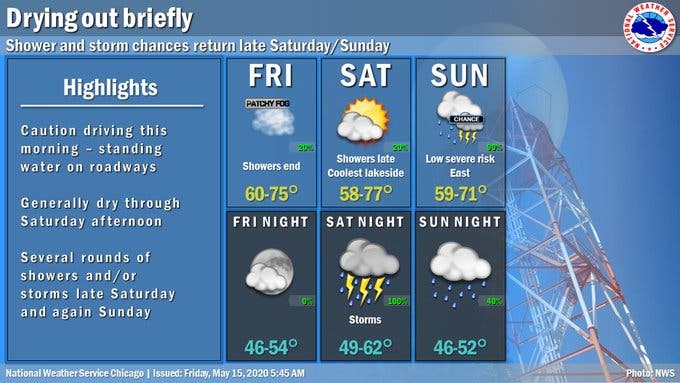
Temperatures will stay in the 70s on Saturday and Sunday, with a high of 77 on Saturday and a high of 71 on Sunday.


ILLINOIS — After a night of heavy rain and flooding in some areas, there will be a slight respite Friday night and Saturday with dry weather expected. Friday night and Saturday will be dry, before the rain returns Saturday night.
Temperatures will stay in the 70s on Saturday and Sunday, with a high of 77 on Saturday and a high of 71 on Sunday. Rain will begin Saturday afternoon, with additional chances on Sunday, the weather service said. There is also a low severe weather risk on Sunday.
The rainfall on Thursday and into early Friday marked the wettest day since Oct. 14, 2017, according to the weather service.
Find out what's happening in Lemontfor free with the latest updates from Patch.
Here is a more detailed look at the weather this weekend, with a forecast from the National Weather Service. Some of the highest rain totals were seen in West Chicago (4.98 inches), Sycamore (4.75 inches), Park Ridge (4.71 inches) and St. Charles (4.69 inches).
FRIDAY NIGHT: Partly cloudy, with a low around 50. North northwest wind around 5 mph becoming east northeast in the evening.
Find out what's happening in Lemontfor free with the latest updates from Patch.
SATURDAY: A 30 percent chance of showers after 1 p.m. Partly sunny, with a high near 69. East northeast wind around 10 mph, with gusts as high as 15 mph.
SATURDAY NIGHT: Showers and possibly a thunderstorm. Low around 56. East northeast wind around 10 mph becoming southeast after midnight. Chance of precipitation is 100 percent.
SUNDAY: Showers and possibly a thunderstorm. High near 67. South wind 10 to 15 mph becoming west southwest in the afternoon. Winds could gust as high as 20 mph. Chance of precipitation is 90 percent.
SUNDAY NIGHT: A 40 percent chance of showers. Mostly cloudy, with a low around 50.
Get more local news delivered straight to your inbox. Sign up for free Patch newsletters and alerts.