Weather
Flood Watch, Rain And Storms For Illinois' First Day Of Summer
The summer solstice is today and unfortunately, it looks like rain and storms all day today and Friday.

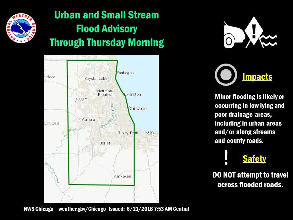
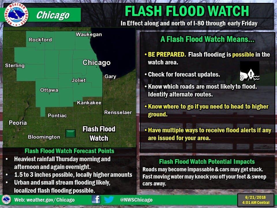
Most of the Chicago area can expect rain to continue throughout the day, and a flash flood watch is in effect until 7 a.m. Friday, June 22. The National Weather Service has also issued a flood advisory for most of the area, including Kendall, Lake, Will, Grundy, Kankakee, Kane, McHenry, DuPage and Cook counties.
The NWS said the flood advisory is for minor flooding in poor drainage areas. Radar has indicated moderate to heavy rain continuing through the rest of the morning Thursday. Minor flooding has been reported and will continue across this area, including the Chicago metro.
According to the NWS, over an inch and a half of rain had already fallen Thursday morning in some areas.
Find out what's happening in Lemontfor free with the latest updates from Patch.
According to the NWS, scattered thunderstorms will continue Thursday and Thursday night. The storms are expected to produce periods of moderate to heavy rain, with the heaviest rains expected along and north of I-80. Some storms that develop south of I-80 could produce strong gusty winds and an isolated severe storm is possible.
Here is a look at the next couple of days and what to expect:
Find out what's happening in Lemontfor free with the latest updates from Patch.
- THURSDAY: Periods of showers and possibly a thunderstorm. Some of the storms could produce heavy rain. High near 71. East northeast wind around 15 mph, with gusts as high as 20 mph. Chance of precipitation is 100%. New rainfall amounts between three quarters and one inch possible.
- THURSDAY NIGHT: Periods of showers and possibly a thunderstorm. Some storms could produce heavy rain. Low around 62. East northeast wind 10 to 15 mph. Chance of precipitation is 100%. New rainfall amounts between a half and three quarters of an inch possible.
- FRIDAY: Showers likely and possibly a thunderstorm before 1 p.m., then a chance of showers and thunderstorms after 1 p.m. Cloudy, with a high near 71. Northeast wind around 10 mph, with gusts as high as 15 mph. Chance of precipitation is 70%. New rainfall amounts between a quarter and half of an inch possible.
- FRIDAY NIGHT: A chance of showers and thunderstorms before 1 a.m., then a slight chance of showers. Cloudy, with a low around 60. North northeast wind 5 to 10 mph. Chance of precipitation is 40%.
Image via Shutterstock.
Get more local news delivered straight to your inbox. Sign up for free Patch newsletters and alerts.

