Weather
Snow Flurries Spotted, Frost & Cold Temps Stick Around In IL
It will be a cooler weekend with some rain possible on Sunday.

With chillier temperatures setting in across Illinois, some locations also reported light snow on Friday. According to the NWS Chicago Twitter, Pontiac airport had visibility as low as 3/4 of a mile because of the snow. Snow was also reported near Dwight and some flakes were seen in downtown Chicago around 1 p.m. Flurries were also reported in the Woodridge area on Friday afternoon.
Really coming down now! Odell, IL #ILwx Starting to accumulate on the grass! 1:20pm @NWSChicago @NWSLincolnIL pic.twitter.com/Q4XqheRqBT
— Cubs Weather (@cubsweather) October 12, 2018
The cold temperatures are expected to stick around this weekend and a frost advisory has been issued for Saturday morning for most of the area, according to the NWS.
Saturday has a high of 55 degrees, while it will get down to 43 degrees on Saturday night. Sunday will be much of the same, but there is also a chance of rain on Sunday afternoon and evening.
Find out what's happening in Lemontfor free with the latest updates from Patch.
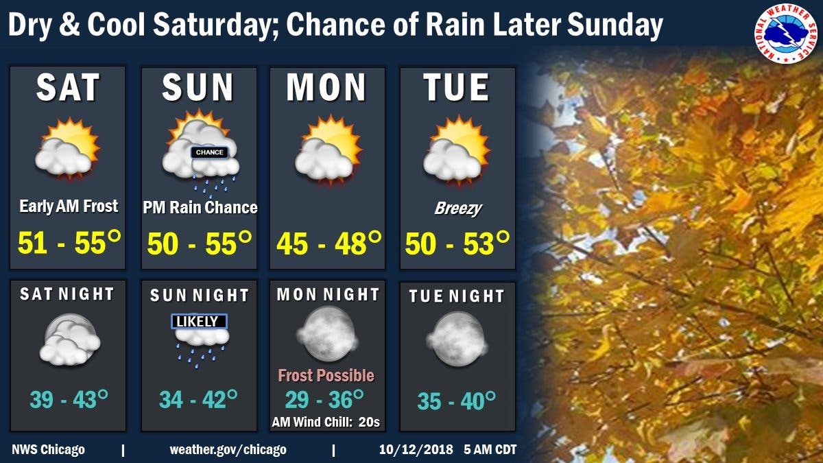
Here is a more detailed look at your weather this weekend:
- FRIDAY NIGHT: Widespread frost, mainly after 5 a.m. Otherwise, cloudy during the early evening, then gradual clearing, with a low around 33. West wind around 5 mph.
- SATURDAY: Widespread frost, mainly before 8 a.m. Otherwise, mostly sunny, with a high near 53. Southwest wind 5 to 10 mph, with gusts as high as 15 mph.
- SATURDAY NIGHT: Partly cloudy, with a low around 39. South southwest wind around 5 mph.
- SUNDAY: A 40 percent chance of rain after 1 p.m. Mostly cloudy, with a high near 53. South wind around 5 mph becoming west northwest in the afternoon.
- SUNDAY NIGHT: Rain likely, mainly before 1 a.m. Mostly cloudy, with a low around 37. Chance of precipitation is 70%.
Find out what's happening in Lemontfor free with the latest updates from Patch.
Get more local news delivered straight to your inbox. Sign up for free Patch newsletters and alerts.

