Weather
Severe Thunderstorm Watch Issued For IL
With the warm weather we've been having, the likelihood of thunderstorms also increases.


A severe thunderstorm watch has been issued for most of the Chicago area as storms roll in Wednesday night. According to the National Weather Service, a severe thunderstorm watch is in effect until 11 p.m. Wednesday. Boone, Cook, Ford, De Kalb, DuPage, Grundy, Jo Daviess, Kane, Kankakee, Kendall, Lake, Lee, McHenry and Will counties all fall under the watch.
The Chicago area could see a few more thunderstorms over the next few days. With the summer-like warmth over the past few days, thunderstorm chances also increase. According to the National Weather Service, thunderstorm potential will increase Wednesday night as a slow-moving cold front approaches from the northwest.
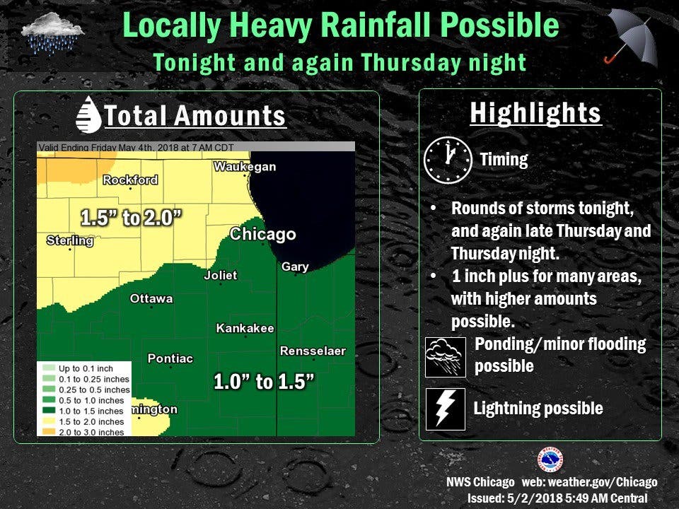
Some storms could be severe, with damaging winds and large hail, especially during the evening and early overnight hours. According to the NWS, the severe threat will decrease with time, but locally heavy rainfall, up to an inch, is possible.
Find out what's happening in Lemontfor free with the latest updates from Patch.
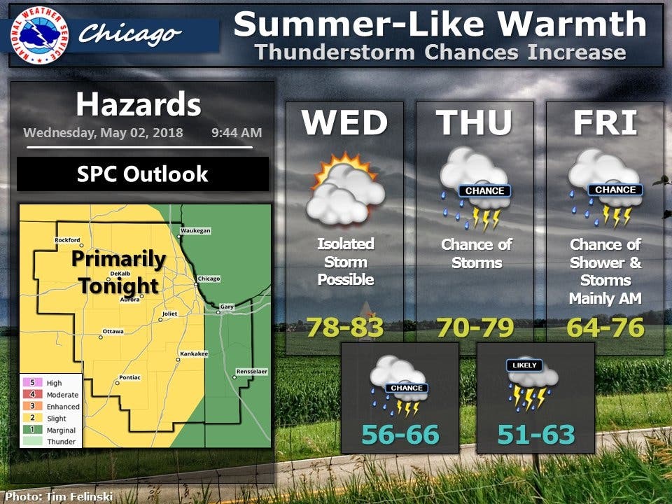
On Thursday, the severe thunderstorm risk continues, as an area of low pressure will move across the area Thursday night into Friday morning. According to the National Weather Service, thunderstorms are possible during the day Thursday, but the potentially strong to severe storms would be from Thursday afternoon into late Thursday night. Damaging winds, large hail and locally heavy rainfall will also be possible with these
storms. The thunderstorms will end from northwest to southeast on Friday.
Here's a more detailed look at the next few days:
Find out what's happening in Lemontfor free with the latest updates from Patch.
- WEDNESDAY AFTERNOON: A 30 percent chance of showers and thunderstorms after 5 p.m. Partly sunny, with a high near 82. Southwest wind around 15 mph, with gusts as high as 25 mph.
- WEDNESDAY NIGHT: Showers and thunderstorms likely, then showers and possibly a thunderstorm after 11 p.m. Low around 64. Southwest wind 5 to 15 mph, with gusts as high as 20 mph. Chance of precipitation is 80%. New rainfall amounts between a half and three quarters of an inch possible.
- THURSDAY: Showers and possibly a thunderstorm, mainly before 2 p.m., then a chance of showers and thunderstorms after 2 p.m. High near 76. Southwest wind 10 to 15 mph. Chance of precipitation is 90%. New rainfall amounts between a quarter and half of an inch possible.
- THURSDAY NIGHT: Showers and thunderstorms likely, mainly between 8 p.m. and 2 a.m., then showers likely and possibly a thunderstorm after 2 a.m. Cloudy, with a low around 60. South wind 10 to 15 mph, with gusts as high as 25 mph. Chance of precipitation is 60%.
- FRIDAY: Showers likely and possibly a thunderstorm before 8 a.m., then a chance of showers between 8 a.m. and 2 p.m. Partly sunny, with a high near 73. West wind around 10 mph, with gusts as high as 15 mph. Chance of precipitation is 60%.
Get more local news delivered straight to your inbox. Sign up for free Patch newsletters and alerts.

