Weather
Up To 2 Inches Of Snow Could Impact IL Commute
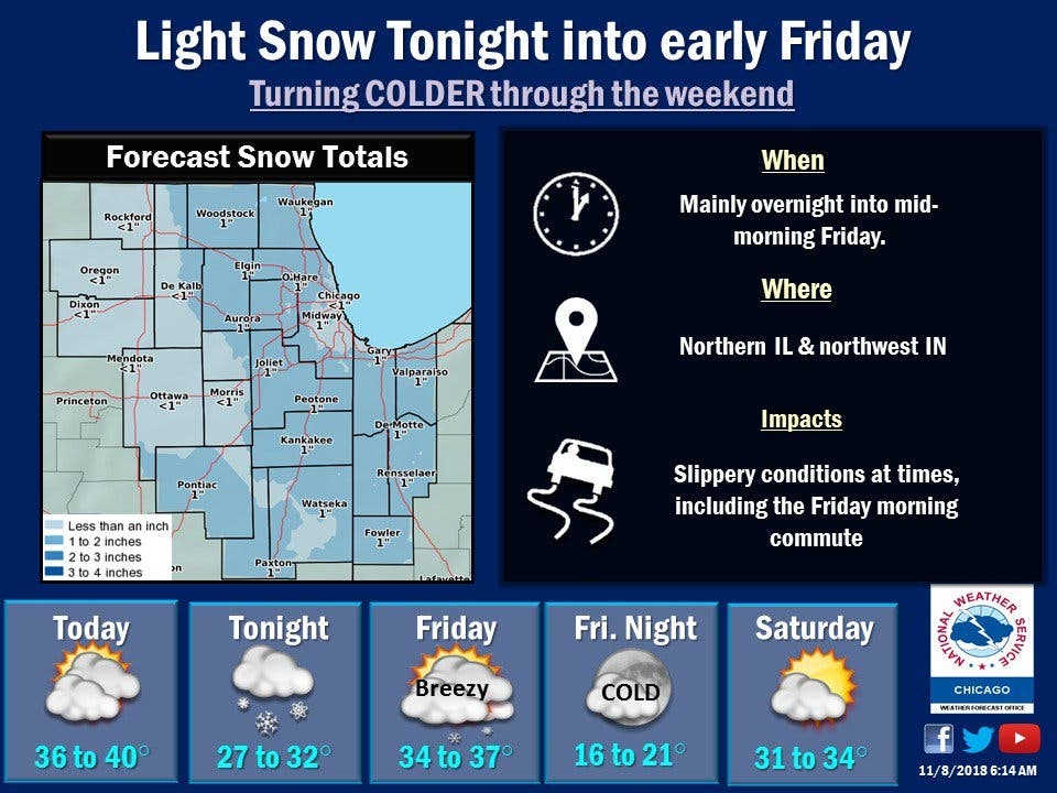
Most areas will see 1/2 inch up to 2 inches of snow.


A round of light accumulating snowfall will start Thursday night into Friday morning and could impact the Friday morning commute. According to the National Weather Service, most areas will see 1/2 inch up to 2 inches of snow.
The snow will taper off Friday morning, although a few afternoon snow showers are possible, the NWS said. Friday will also be windy with gusts up to 35 mph in the afternoon and evening. Wind chills will drive temps into the teens on Friday evening and into the single digits overnight.
According to the NWS, Chicago should see less than an inch of snow, while Midway, Aurora and Joliet could all see an inch.
Find out what's happening in Lemontfor free with the latest updates from Patch.
Here is a detailed look at the weather on Thursday and Friday:
- THURSDAY NIGHT: Snow, mainly after 10 p.m. Low around 31. Calm wind becoming west northwest around 5 mph after midnight. Chance of precipitation is 100%. New snow accumulation of less than one inch possible.
- FRIDAY: Snow likely before 10 a.m., then rain and snow likely between 10 a.m. and 4 p.m., then a slight chance of snow after 4 p.m. Cloudy, with a high near 36. West northwest wind 5 to 15 mph, with gusts as high as 25 mph. Chance of precipitation is 70%. New snow accumulation of less than a half inch possible.
- FRIDAY NIGHT: A 20 percent chance of snow before midnight. Mostly cloudy, then gradually becoming mostly clear, with a low around 20. West northwest wind around 15 mph, with gusts as high as 30 mph.
Image via Shutterstock.
Find out what's happening in Lemontfor free with the latest updates from Patch.
Get more local news delivered straight to your inbox. Sign up for free Patch newsletters and alerts.

