Weather
Snow In The Forecast: Up To 2 Inches Expected In Some Areas
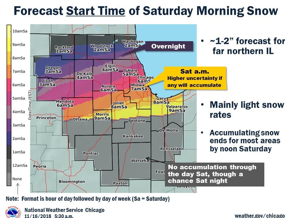
Snow is expected to start late Friday night and continue into Saturday.


Another round of light snow will be in the area this weekend. According to the National Weather Service, light to moderate snow is likely in far northern Illinois late Friday night. Minor accumulation is expected by daybreak on Saturday, mainly in far north suburbs near the Wisconsin state line. One to two inches of snow is expected for the northern suburbs, while the southern suburbs will get less than an inch.
The snow will continue on Saturday morning, especially along and north of I-88. The NWS said minor accumulation is likely and it could cause some impacts to Saturday morning travel. Light snow accumulation is also possible south of I-80 on Saturday night.
Temps will remain in the mid-30s on both Saturday and Sunday, and the high for both days is near 35 degrees. After the snow on Friday night and SAturday, Sunday should be mostly sunny.
Find out what's happening in Lemontfor free with the latest updates from Patch.
Here is a more detailed look at the weather this weekend:
- FRIDAY NIGHT: A 50 percent chance of snow, mainly after 4 a.m. Cloudy, with a low around 30. West southwest wind around 5 mph becoming calm in the evening.
- SATURDAY: Snow, mainly before noon. High near 35. East northeast wind 5 to 10 mph becoming north in the morning. Chance of precipitation is 90 percent. New snow accumulation of around an inch possible.
- SATURDAY NIGHT: Mostly cloudy, with a low around 26. North wind 5 to 10 mph.
- SUNDAY: Mostly sunny, with a high near 35. North wind around 5 mph becoming west in the afternoon.
- SUNDAY NIGHT: Mostly clear, with a low around 22.
Image via Shutterstock.
Find out what's happening in Lemontfor free with the latest updates from Patch.
Get more local news delivered straight to your inbox. Sign up for free Patch newsletters and alerts.

