Weather
More Snow, Then 70-Degree Temps Expected In Illinois This Week
It looks like we are shedding the last vestiges of winter, and temperatures will start to warm up this week.


It looks like the last bit of winter will be gone by the end of this week. First, however, there is some snow in the forecast for Sunday night into Monday. According to the National Weather Service, snow will spread over the area Sunday night and produce some light accumulations.
1 to 2 inches of snow is expected for the far western parts of Illinois, while the Chicagoland area will receive less than an inch of snow.
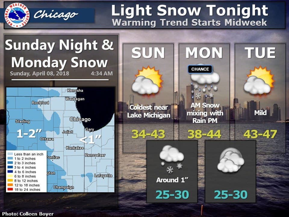
After Monday's chance of snow, temperatures will begin to warm up and become more spring-like. According to the NWS, Monday will feature chances of snow and rain and the high will be near 42 degrees. Tuesday will be similar with a high of 46, although it will be mostly sunny.
Find out what's happening in Lemontfor free with the latest updates from Patch.
The sun will continue on Wednesday and temperatures will take a jump up to 59 degrees. According to the NWS, there is a chance of showers and thunderstorms late Wednesday night into Thursday. The rain will clear for Thursday during the day, and it will be mostly sunny with a high of 65 degrees.
Friday will be the warmest day of the week, with a high of 66 degrees. There will be a chance of rain and thunderstorms on Friday, but it seems like spring is here to stay!
Find out what's happening in Lemontfor free with the latest updates from Patch.
Here is a more detailed look at your week ahead forecast:
- SUNDAY NIGHT: Snow, mainly after 10 p.m. Low around 29. East wind 5 to 10 mph. Chance of precipitation is 80 percent. New snow accumulation of less than one inch possible.
- MONDAY: A chance of snow before 11 a.m., then a chance of rain. Cloudy, with a high near 42. East wind around 5 mph becoming north northeast in the afternoon. Chance of precipitation is 40 percent.
- MONDAY NIGHT: A slight chance of rain and snow before 9 p.m., then a slight chance of snow between 9 p.m. and 1 a.m. Mostly cloudy, with a low around 28. Northeast wind around 5 mph becoming northwest after midnight. Chance of precipitation is 20%.
- TUESDAY: Mostly sunny, with a high near 46. West wind 5 to 10 mph.
- TUESDAY NIGHT: Partly cloudy, with a low around 34.
- WEDNESDAY: Partly sunny, with a high near 59.
- WEDNESDAY NIGHT: A chance of showers, with thunderstorms also possible after 1 a.m. Mostly cloudy, with a low around 46.
- THURSDAY: Mostly sunny, with a high near 65.
- THURSDAY NIGHT: A slight chance of showers and thunderstorms after 1 a.m. Mostly cloudy, with a low around 43.
- FRIDAY: A chance of showers and thunderstorms. Mostly cloudy, with a high near 66.
- FRIDAY NIGHT: A chance of showers and thunderstorms. Mostly cloudy, with a low around 46.
Get more local news delivered straight to your inbox. Sign up for free Patch newsletters and alerts.

