Weather
Storms, 45 MPH Wind Gusts Possible As Cold Front Moves Into IL
Temperatures are expected to remain fairly warm until Thursday, when highs drop into the 50s.


ILLINOIS — Warmer temperatures are expected to continue until mid-week in the Chicago area. Temps in the 60s are expected Monday, before a cold front as well as showers and storms move into the area by the afternoon. According to the National Weather Service, showers and thunderstorms are expected, and some could produce locally strong wind gusts up to 50 mph and small hail.
After the storms move out of the area Monday afternoon, wind gusts of up to 40 to 45 mph are expected.
.jpg)
Temperatures will warm up again on Tuesday, which has a high of 74, according to the weather service. Wednesday will also be in the 70s, with a high of 75 expected. Both days will be breezy.
Find out what's happening in Lemontfor free with the latest updates from Patch.
The weather service said the windy and dry conditions could also result in elevated to critical fire weather conditions Tuesday and Wednesday afternoons.
After Wednesday, temperatures begin to turn cooler, and Thursday and Friday have highs of 57 and 51, respectively.
Find out what's happening in Lemontfor free with the latest updates from Patch.
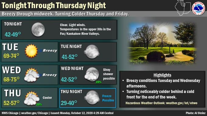
Here is a more detailed look at the weather this week, with a forecast from the National Weather Service:
MONDAY: Showers and thunderstorms before 3 p.m., then a chance of showers between 3 p.m. and 4 p.m. Temperature falling to around 58 by 3 p.m. Breezy, with a south southeast wind 15 to 25 mph becoming west northwest in the afternoon. Winds could gust as high as 40 mph. Chance of precipitation is 100 percent. New rainfall amounts between a tenth and quarter of an inch, except higher amounts possible in thunderstorms.
MONDAY NIGHT: Clear, with a low around 44. West northwest wind 5 to 10 mph becoming southwest after midnight.
TUESDAY: Sunny, with a high near 72. Breezy, with a south southwest wind 5 to 10 mph increasing to 15 to 20 mph in the afternoon. Winds could gust as high as 30 mph.
TUESDAY NIGHT: Mostly clear, with a low around 45. West wind 5 to 10 mph becoming north after midnight.
WEDNESDAY: Partly sunny, with a high near 72. South wind 5 to 10 mph increasing to 10 to 15 mph in the afternoon. Winds could gust as high as 30 mph.
WEDNESDAY NIGHT: A 20 percent chance of showers after 1 a.m. Mostly cloudy, with a low around 48.
THURSDAY: A 20 percent chance of showers before 1 p.m. Partly sunny, with a high near 55.
THURSDAY NIGHT: Mostly clear, with a low around 34.
FRIDAY: Mostly sunny, with a high near 51.
FRIDAY NIGHT: Partly cloudy, with a low around 33.
Get more local news delivered straight to your inbox. Sign up for free Patch newsletters and alerts.