Weather
Thunderstorms, Snow, Above Average Temperatures For Illinois
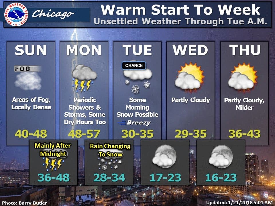
Warmer temperatures on Monday will bring rain and thunderstorms, before cooling down again for the middle of the week.


This week will have a little bit of everything: rain, thunderstorms, warmer temperatures and even some snow showers. According to the National Weather Service, the weather will be unsettled through Tuesday morning. Monday will bring rain, thunderstorms, and a high of 56 degrees. It will turn colder Monday night, and snow and some thunder could be likely after 4 a.m.
Tuesday will see a chance of snow before 9 a.m., but temperatures will be back down in the 30s. The rest of the week will be more consistent, with temperatures in the mid-30s. However, temperatures will start to rise again, according to NWS. The high for Thursday will be 43 degrees, and Friday's high is 49 degrees.
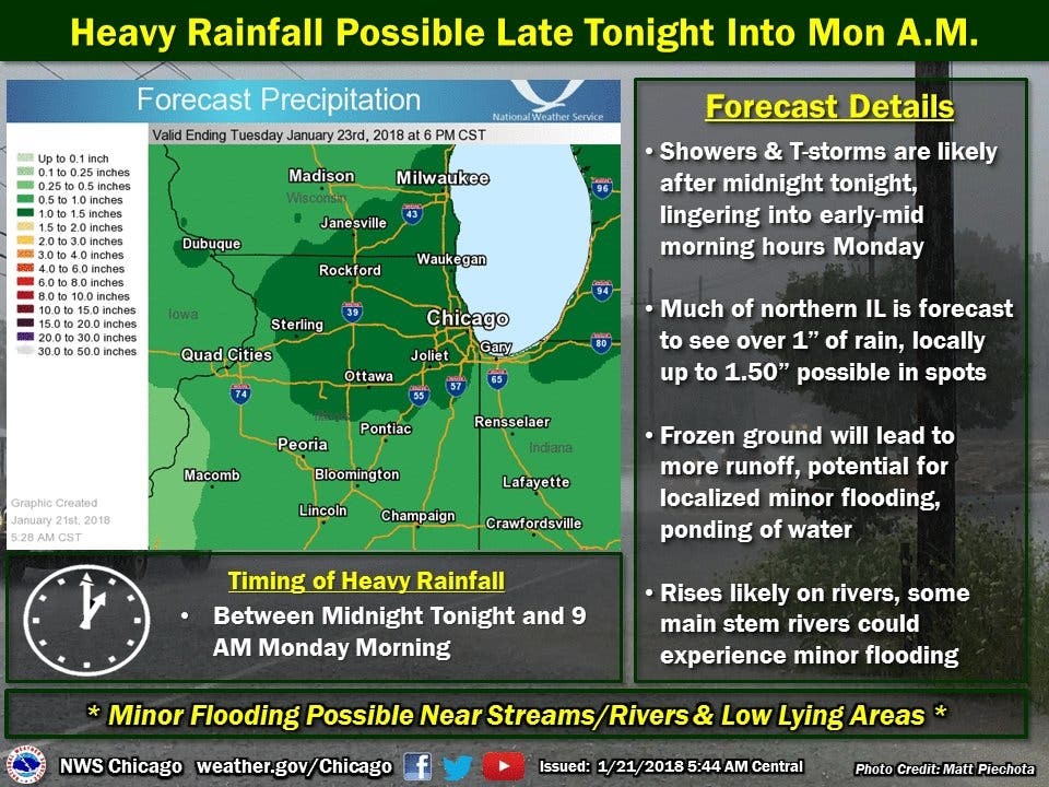
There is also a chance for heavy rainfall starting Sunday night into Monday morning. According to the NWS, 1 to 1.5 inches or rain is expected for the Chicago area. The frozen ground will also lead to more runoff, and the potential for localized minor flooding and ponding of water.
Find out what's happening in Lemontfor free with the latest updates from Patch.
Here is your forecast for this week:
- SUNDAY NIGHT: Showers likely, then showers and possibly a thunderstorm after midnight. Areas of dense fog. Temperature rising to around 48 by 5 a.m. South southeast wind around 5 mph. Chance of precipitation is 100 percent. New rainfall amounts between a half and three quarters of an inch possible.
- MONDAY: Showers and possibly a thunderstorm before noon, then a chance of showers and thunderstorms after noon. High near 56. South wind 10 to 15 mph, with gusts as high as 25 mph. Chance of precipitation is 100 percent. New rainfall amounts between a quarter and half of an inch possible.
- MONDAY NIGHT: Rain showers likely before 2 a.m., then rain and snow showers likely between 2 a.m. and 4 a.m., then snow likely after 4 a.m. Some thunder is also possible. Cloudy, with a low around 32. South wind around 10 mph becoming west northwest after midnight. Winds could gust as high as 15 mph. Chance of precipitation is 70 percent. New snow accumulation of less than a half inch possible.
- TUESDAY: A 30 percent chance of snow before 9 a.m. Mostly cloudy, with a high near 33. West northwest wind 10 to 15 mph, with gusts as high as 25 mph.
- TUESDAY NIGHT: Partly cloudy, with a low around 21.
- WEDNESDAY: Mostly sunny, with a high near 32.
- WEDNESDAY NIGHT: Partly cloudy, with a low around 21.
- THURSDAY: Mostly sunny, with a high near 39.
- THURSDAY NIGHT: Partly cloudy, with a low around 31.
- FRIDAY: Mostly sunny, with a high near 49.
- FRIDAY NIGHT: A chance of showers. Mostly cloudy, with a low around 40.
Find out what's happening in Lemontfor free with the latest updates from Patch.
Get more local news delivered straight to your inbox. Sign up for free Patch newsletters and alerts.

