Weather
Chicago Weather: Heaviest Snowfall Since 2015 Super Bowl Expected
Illinois winter storm warning now set to end at noon, 9 a.m. depending on location.

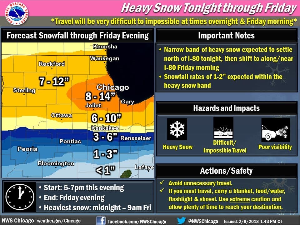
The latest round of snow is upon us. The National Weather Service issued a winter storm warning starting at 6 p.m. Thursday. Originally, the warning was set to expire at 9 p.m. Friday. By late Thursday, the National Weather Service has revised the warning, which now ends at noon Friday in DuPage, Cook, La Sale, Kendall, Grundy, Will and Lake Counties and 9 a.m. in Boone, Winnebago, McHenry, Lake, Ogle, Lee and Kane counties. Heavy snow is possible and travel could be difficult — including during the morning and evening commutes on Friday. Total snow accumulation between 10 to 15 inches is possible.
According to the NWS, flurries will start during the day Thursday and heavy snow will spread across the area Thursday evening and Friday. The snow should start between 5 and 7 p.m. Thursday, and the heaviest snow will be between midnight and 9 a.m. Friday.
Find out what's happening in Plainfieldfor free with the latest updates from Patch.
According to the NWS, there is a narrow band of heavy snow expected to settle north of I-80 on Thursday night, which will then shift near I-80 on Friday morning. Snowfall rates of 1 to 2 inches are expected within the heavy snow band, according to the NWS. Some Chicago suburbs may see up to 14 inches of snow.
The projected snow totals represent the heaviest snowfall since Super Bowl Sunday in 2015, when the Chicago area got hit with more than 19 inches of snow, according to WGN.
Find out what's happening in Plainfieldfor free with the latest updates from Patch.
Some area schools and organizations have already reported closures for Thursday and Friday. You can check the Emergency Closing Center's website to stay updated. Metra is also warning commuters of possible weather-related delays, and Waste Management said trash pickup may be one day late for Friday service customers.
The National Weather Service has advised that travel will be very difficult to impossible at times over night and Friday morning.
The Chicago National Weather Service posted on Twitter to say blizzard conditions are not expected, as the winds should stick around 10 mph. The snow should also be light and fluffy, rather than wet and heavy.
Source: National Weather Service.
Here's a more detailed look at the next few days:
- THURSDAY: Snow likely, mainly after 5 p.m. Cloudy, with a high near 22. Southwest wind around 5 mph. Chance of precipitation is 70 percent. Total daytime snow accumulation of less than a half inch possible.
- THURSDAY NIGHT: Snow. The snow could be heavy at times. Temperature rising to around 25 by 4 a.m. South wind 5 to 10 mph becoming east northeast after midnight. Chance of precipitation is 100 percent. New snow accumulation of 6 to 10 inches possible.
- FRIDAY: Snow. The snow could be heavy at times. High near 29. North northeast wind 5 to 10 mph, with gusts as high as 15 mph. Chance of precipitation is 100 percent. New snow accumulation of 3 to 5 inches possible.
- FRIDAY NIGHT: Snow likely, mainly after midnight. Cloudy, with a low around 14. North wind 5 to 10 mph. Chance of precipitation is 60 percent. New snow accumulation of less than one inch possible.
- SATURDAY: Snow likely, mainly before noon. Cloudy, with a high near 23. North wind around 5 mph. Chance of precipitation is 60 percent.
Get more local news delivered straight to your inbox. Sign up for free Patch newsletters and alerts.