Community Corner
Super Bowl Weekend Weather: Snowfall Likely Saturday Evening, Sunday
Northeast winds are expected to pick up Sunday, blowing fluffy snow around in 'near blizzard conditions.'

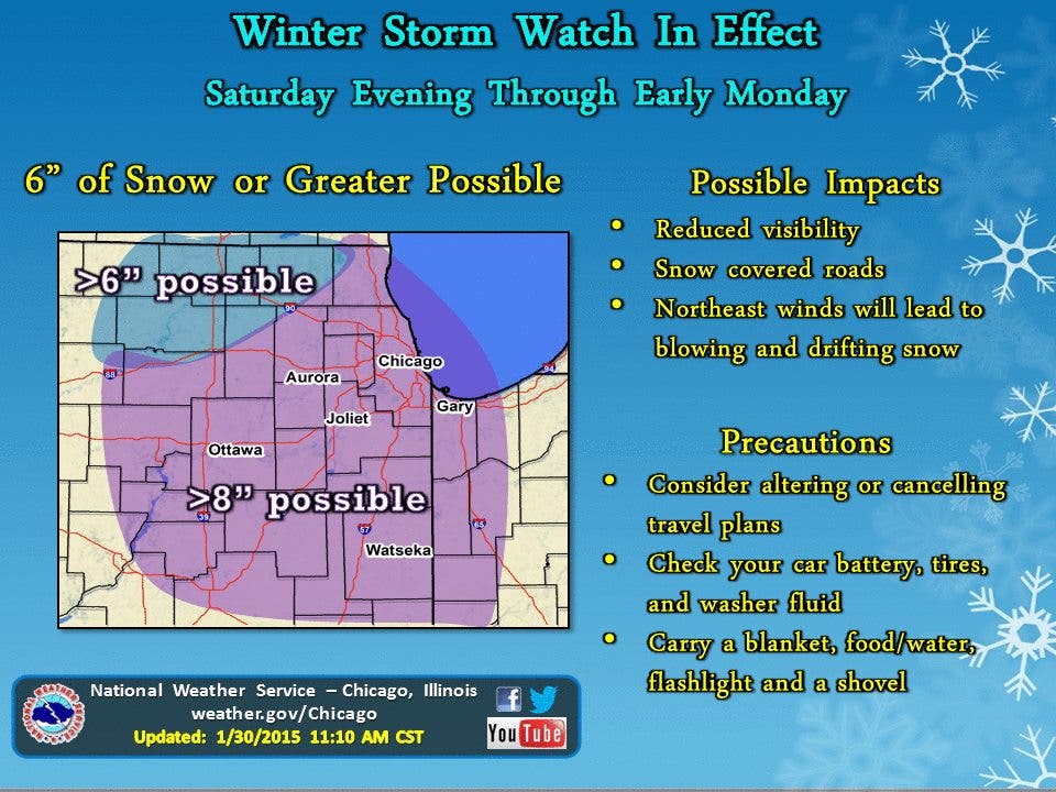
A Winter Storm Watch will be in place Saturday evening to Monday morning for DuPage, Cook and other Illinois counties, according to the National Weather Service.
More than eight inches of snowfall is possible south of Interstate 88, and more than six inches of snow could fall north of Interstate 88, according to the watch. Visibility may be reduced to less than a mile.
Northeast winds are expected to pick up Sunday, blowing fluffy snow around in “near blizzard conditions” on roads, in open areas and especially on the lakefront, according to the NWS forecast. This could affect travel plans to Super Bowl gatherings.
Find out what's happening in Woodridgefor free with the latest updates from Patch.
Friday night in Woodridge is expected to be be partly cloudy with a low of 18 degrees. Cloud cover will grow Saturday, with high temperatures near 35.
The air will slowly cool Saturday as moisture arrives, and there’s a 90 percent chance of snow Saturday night, with a low of 25 degrees, NWS reported. Two to four inches of new snow accumulation is possible.
Find out what's happening in Woodridgefor free with the latest updates from Patch.
That 90 percent chance of snow continues into Sunday, when there could be three to seven inches of new snow accumulation. Some areas may see blowing snow in a bluster northeast wind. The high Sunday should be around 25 degrees, according to NWS.
More snow is likely to fall Sunday night/Monday morning after midnight. Skies will be cloudy, with a low around 11 degrees and more blustery winds.
Monday should be mostly sunny with a high near 17 degrees.
Detailed Forecast for Woodridge, via the National Weather Service:
- This Afternoon: Mostly sunny, with a high near 27. West wind around 5 mph.
- Tonight: Partly cloudy, with a low around 18. Southwest wind 5 to 10 mph.
- Saturday: Increasing clouds, with a high near 35. Southwest wind 5 to 10 mph.
- Saturday Night: Snow. Low around 25. Light and variable wind becoming east northeast 5 to 10 mph after midnight. Chance of precipitation is 90%. New snow accumulation of 3 to 5 inches possible.
- Sunday: Snow with areas of blowing snow. High near 25. Blustery, with a northeast wind 10 to 20 mph, with gusts as high as 30 mph. Chance of precipitation is 90%. New snow accumulation of 3 to 7 inches possible.
- Sunday Night: Snow likely with areas of blowing snow before midnight, then a chance of snow showers after midnight. Cloudy, with a low around 11. Blustery. Chance of precipitation is 70%.
- Monday: Mostly sunny, with a high near 17.
- Monday Night: A slight chance of snow. Mostly cloudy, with a low around 12.
- Tuesday: A slight chance of snow. Mostly cloudy, with a high near 29.
- Tuesday Night: A chance of snow. Mostly cloudy, with a low around 21.
- Wednesday: A slight chance of snow. Partly sunny, with a high near 23.
- Wednesday Night: A slight chance of snow. Partly cloudy, with a low around 4.
- Thursday: Mostly sunny, with a high near 15.
Get more local news delivered straight to your inbox. Sign up for free Patch newsletters and alerts.