Weather
Maryland Faces Triple Threat From Hurricane Isaias Remnants
Maryland faces 1.5 to 2.5 inches of rain, isolated higher totals, possible tornadoes and coastal flooding as Isaias moves north.


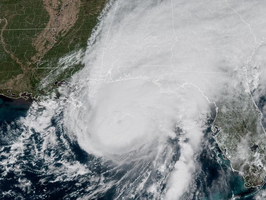
The remnants of Hurricane Isaias could bring up to 4 inches of rain, damaging winds, isolated tornadoes and coastal flooding to Maryland, with the worst conditions expected Sunday, according to the latest National Weather Service forecast.
Forecasters have increased their expectations for rainfall and severe weather as the system moves north toward the Mid-Atlantic. A coastal flood watch is in effect for Anne Arundel County, while a wind advisory is in effect for western Garrett County.
The National Weather Service expects widespread rainfall totals of 1.5 to 2.5 inches across the Baltimore-Washington region, with isolated amounts reaching 3 to 4 inches. Wind gusts could reach 40 to 50 mph in western Maryland's mountains, while other areas could see gusts of 20 to 30 mph.
Find out what's happening in Across Marylandfor free with the latest updates from Patch.
Forecasters also warned that damaging thunderstorms and a few brief tornadoes are possible Sunday afternoon, particularly east of the Blue Ridge and Catoctin mountains.
.jpg)
When Will Hurricane Isaias Impact Maryland?
Rain is expected to spread northward into Maryland late Saturday night and become heavier after midnight as tropical moisture moves into the region.
Find out what's happening in Across Marylandfor free with the latest updates from Patch.
The heaviest widespread rainfall is expected Sunday morning into early afternoon, according to the National Weather Service.
A separate round of thunderstorms could develop Sunday afternoon as the remnants of Isaias move through the region. Some storms could produce damaging winds or brief tornadoes.
The National Weather Service has identified a marginal risk of severe thunderstorms extending north to the Maryland-Pennsylvania border.
Rainfall could cause localized flooding, especially in urban areas, neighborhoods with poor drainage and locations near small streams.
AccuWeather said 1 to 4 inches of rain is possible across a broad area extending from the Ohio Valley to the Mid-Atlantic coast. Heavy downpours could produce street flooding where rainfall rates reach an inch per hour or more.
Conditions should begin improving Monday morning as the storm system moves offshore, although some lingering showers and gusty winds are possible.
.jpg)
Coastal Flood Watch Issued For Anne Arundel County
A coastal flood watch is in effect for Anne Arundel County from Sunday afternoon through Sunday evening, when elevated water levels could cause moderate tidal flooding around Annapolis.
The National Weather Service said tides could run 1.5 to 2 feet above normal, with up to 1 foot of water above ground level possible in low-lying shoreline areas.
In downtown Annapolis, flooding could affect the City Dock parking lot, Dock Street and Compromise Street.
Minor tidal flooding is also likely at other locations along the Chesapeake Bay and tidal Potomac River during Sunday's afternoon and evening high tides.
Persistent southeasterly winds are expected to push water into the Chesapeake Bay and Potomac River. The timing of the winds, high tides and new moon could worsen flooding.
Water levels are expected to fall Monday morning as winds shift offshore.
Latest On Hurricane Isaias
Isaias weakened to a post-tropical cyclone Saturday after making landfall near Destin, Florida, as a Category 2 hurricane on Friday night.
At 11 a.m. ET Saturday, the storm was centered about 50 miles south of Birmingham, Alabama, with maximum sustained winds of 35 mph, according to the National Weather Prediction Center.
The system was moving north-northwest at 10 mph and was expected to continue weakening as it moved inland.
Despite losing its tropical characteristics, Isaias continued to threaten flash flooding, damaging winds and severe thunderstorms across parts of the southeastern United States.
The storm has been blamed for at least two deaths, one in Florida and another in Alabama, after trees fell onto homes. Hundreds of thousands of customers also lost electricity across Florida, Alabama and Georgia as the hurricane moved inland.
AccuWeather reported that roughly 800,000 customers across parts of the Southeast remained without power around midday Saturday.
Isaias is expected to continue moving north through the Tennessee Valley before its remnants turn eastward and spread rain and gusty winds across the Mid-Atlantic and Northeast.
Although Maryland is not expected to experience hurricane-force winds, forecasters emphasized that the storm's remnants could still produce hazardous weather, particularly Sunday.
Residents should secure loose outdoor objects, avoid flooded roads and monitor weather alerts throughout the weekend.
Latest Baltimore-Area Forecast
Saturday: Mostly cloudy, with a high near 70. East wind around 8 mph.
Saturday Night: Showers likely, mainly after 4am. Cloudy, with a low around 60. East wind around 8 mph. Chance of precipitation is 60%. New precipitation amounts between a tenth and quarter of an inch possible.
Sunday: Showers, with thunderstorms also possible after 5pm. High near 68. East wind 13 to 15 mph, with gusts as high as 26 mph. Chance of precipitation is 100%. New rainfall amounts between three quarters and one inch possible.
Sunday Night: Showers and possibly a thunderstorm. Low around 63. East wind 5 to 8 mph becoming light and variable. Chance of precipitation is 80%. New precipitation amounts between a quarter and half of an inch possible.
Monday: A chance of showers before 8am. Partly sunny, with a high near 73. Northwest wind 9 to 11 mph, with gusts as high as 22 mph. Chance of precipitation is 30%.
Monday Night: Partly cloudy, with a low around 59.
Tuesday: Sunny, with a high near 79.
Tuesday Night: A slight chance of showers before 2am. Partly cloudy, with a low around 59. Chance of precipitation is 20%.
Wednesday: Sunny, with a high near 70.
Get more local news delivered straight to your inbox. Sign up for free Patch newsletters and alerts.