Weather
MD Weather: Nor'easter To Bring Rain, Strong Winds, Snow
Heavy rain, snow and strong winds are on the way, and could cause flooding in parts of Maryland, the National Weather Service says.

MARYLAND — A coastal storm that could evolve into a powerful nor'easter late Monday or Tuesday is headed to Maryland, according to forecasters.
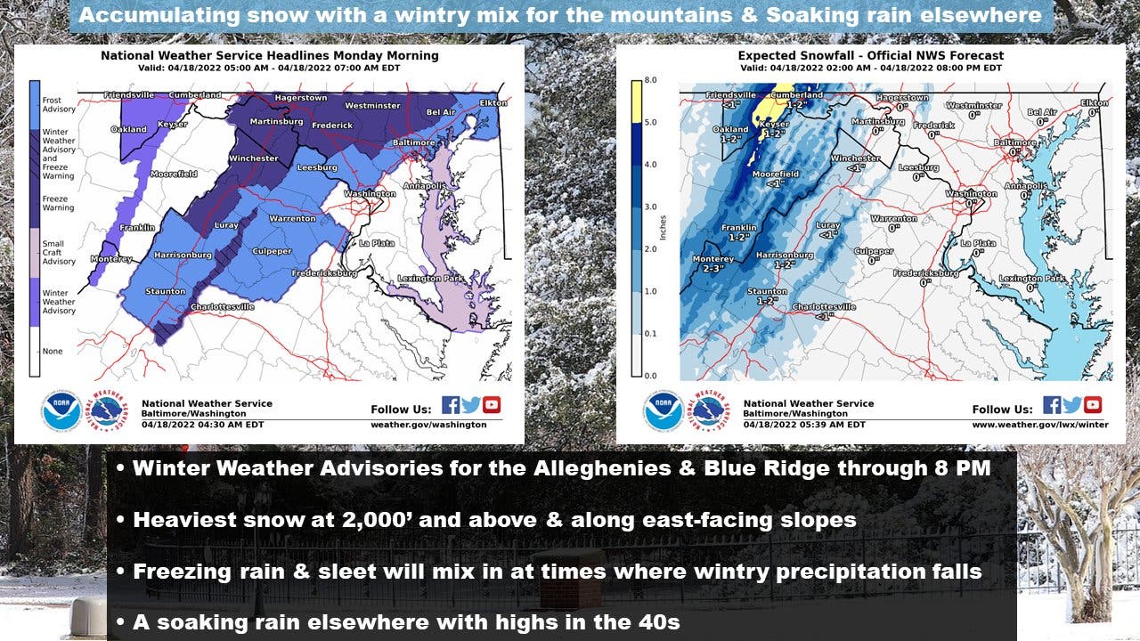
Heavy rain, coastal flooding, and strong winds are possible, the National Weather Service says. Up to 5 inches of snow could fall in the higher elevations of western Maryland, while a wintry mix and rain will fall in other parts of the state.
"A late season winter storm is currently moving into the area," the Weather Service tweeted Monday. "The best chance for snow accumulations will be over the mountains with 3-5" of snow possible, locally higher. However, some of the nearby lower elevations will see a wintry mix. A chilly rain can be found elsewhere."
Find out what's happening in Across Marylandfor free with the latest updates from Patch.
Rain with thunderstorms will start after 5 p.m. Monday, the forecast said, with heavy rain of about an inch is predicted after 2 a.m.
The storm should be a full-fledged nor’easter into Monday night and Tuesday as it tracks from Virginia through DC, Baltimore, Philadelphia and on to New York City, AccuWeather said. The D.C. area will see a high in the upper 40s on Monday afternoon, nearly 20 degrees below average.
Find out what's happening in Across Marylandfor free with the latest updates from Patch.
Heavy rainfall is forecast from Richmond, Virginia, as far north as Boston with strong coastal winds.
A hazardous weather outlook is for the Maryland portion of the Chesapeake Bay, Tidal Potomac River, and I-95 corridor through central Maryland, northern Virginia, and District of Columbia.
A gale warning is in effect for lower portions of the tidal Potomac and middle portions of the Chesapeake Bay Monday into the evening
A winter weather advisory is in effect for Garrett and extreme western Allegany counties until 8 p.m. Monday.
Frost and freeze conditions may affect the area late Tuesday night into Wednesday morning.
Here's the full forecast:
Monday: Rain, with thunderstorms also possible after 5pm. High near 49. East wind 11 to 16 mph, with gusts as high as 29 mph. Chance of precipitation is 100%. New rainfall amounts between a quarter and half of an inch possible.
Monday Night: Rain and possibly a thunderstorm before 2am, then a chance of rain. Low around 39. Northeast wind 14 to 16 mph becoming northwest after midnight. Winds could gust as high as 29 mph. Chance of precipitation is 100%. New precipitation amounts between three quarters and one inch possible.
Tuesday: Mostly sunny, with a high near 53. Breezy, with a west wind 13 to 21 mph, with gusts as high as 36 mph.
Tuesday Night: Mostly clear, with a low around 38. West wind 8 to 14 mph, with gusts as high as 26 mph.
Wednesday: Sunny, with a high near 60. Northwest wind 7 to 9 mph.
Wednesday Night: Partly cloudy, with a low around 45.
Thursday: Partly sunny, with a high near 67.
Thursday Night: Mostly cloudy, with a low around 51.
Friday: Mostly sunny, with a high near 73.
Friday Night: Mostly cloudy, with a low around 53.
Saturday: Partly sunny, with a high near 70.
Saturday Night: Partly cloudy, with a low around 53.
Sunday: Mostly sunny, with a high near 76.
Get more local news delivered straight to your inbox. Sign up for free Patch newsletters and alerts.