Weather
Worst Flood In 20 Years Possible, Up To 5-Foot Surge Expected In Anne Arundel
The worst flood in 20 years could be on its way to Anne Arundel County. Officials forecast up to 5 feet of inundation.

ANNE ARUNDEL COUNTY, MD — Anne Arundel County is bracing for what could be one of the worst floods in 10 to 20 years, officials announced Thursday. The National Weather Service issued a coastal flood warning that lasts until 2 p.m. Saturday.
In that bulletin, meteorologists called for 2 to 3 feet of inundation above ground level. The worst flooding is expected Friday and Saturday.
A Friday storm could add to the problem, bringing wind and water from the East toward Maryland's western shore.
Find out what's happening in Annapolisfor free with the latest updates from Patch.
The wind may peak Friday night. Sustained breezes of 20 to 25 mph are forecast, and gusts of up to 35 mph are possible.
The latest weather updates are posted on the National Weather Service's website and Twitter.
Find out what's happening in Annapolisfor free with the latest updates from Patch.
Several Coastal Flood Warnings have been issued along the Chesapeake Bay and Tidal Potomac River. Water levels are already on the rise and will only rise more throughout the day today and into Friday. Tidal inundation levels of 2-4 feet are expected in low-lying coastal areas. pic.twitter.com/dObvOQdto8
— NWS Baltimore-Washington (@NWS_BaltWash) October 28, 2021
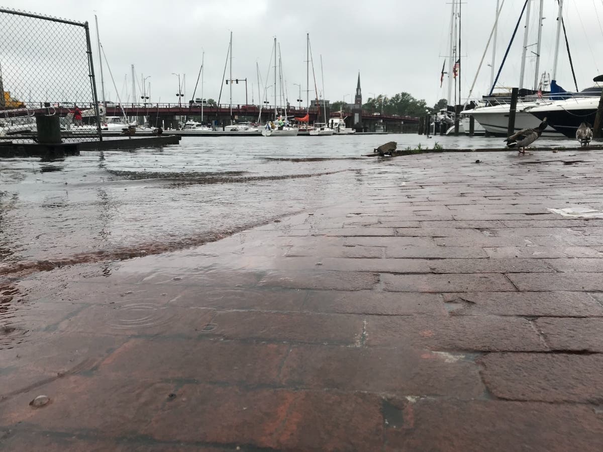
Annapolis Flooding
The Annapolis government warned the tide could rise by 5.3 feet. The city had a 3.31-foot tide by 10:12 a.m. Thursday. That was the highest since April 2020, and it puts the Severn River at a moderate flood stage.
The record storm surge was 7.16 feet. That came during Tropical Storm Isabel on Sept. 19, 2003.
To keep up with the live flooding statistics, click here.
One of the biggest tidal flood events of the past 10-20 years (possibly since Hurricane Isabel at some locales), is expected Friday & Saturday. Those along tidal shores should get ready for exceptional tidal inundation! Tidal forecasts here: https://t.co/Q2WdpDGgIJ pic.twitter.com/LQkL80pzQs
— NWS Baltimore-Washington (@NWS_BaltWash) October 28, 2021
Road Closure
The tide has already disrupted Annapolis. Water on Thursday morning reached the Kunta Kinte-Alex Haley Memorial, a statue that sits about 15 feet from the bulkhead.
Compromise Street, which crosses the Spa Creek Bridge, closed Thursday morning. The road has since reopened.
The thoroughfare usually shuts down when floodwaters reach 3.1 feet. That's also when the pumps along Dock Street start to get overwhelmed.
Downtown flooding may be the most disruptive from Friday afternoon through Sunday morning.
Preparation
The City of Annapolis Department of Public Works began offering free sandbags Thursday at 8 a.m. The self-service event will continue on Compromise Street in the Donner Lot until 5 p.m. or until the supplies run out.
The resources are only open to city residents and businesses. Attendees must show identification. Workers will provide bags and shovels.
The Annapolis Harbormaster asked captains to check on their boats after each high tide. They should also move their vessels from an anchor to a mooring ball when possible. The owners of any boat that drags anchor and damages property will be held responsible.
"As water levels return to normal, boats may become lodged on fixed structures or atop other boats," the city said in a press release. "This can result in a vessel taking on water or sinking. Please check boats to prevent fuel leaks and property damage."
Leaders also urged residents to clear their gutters, check their streetside storm drains and secure loose outdoor belongings. Annapolis officials additionally reminded residents not to drive through standing water or park in closed lots.
"It only takes a few inches of water to turn a car into a boat (one without a motor or steering)," the city added. "Take the advice that the National Weather Service offers: 'Turn Around. Don’t Drown!'"
Officials recommended signing up for "Alert Annapolis," which sends phone, text and email updates during emergencies. Head to alertannapolis.regroup.com to register.
The Office of Emergency Management also suggested downloading the "Prepare Me Annapolis" mobile application. This free app delivers push notifications about city functions and activities before crises.
Subscribe to your local Patch newsletter. Download our mobile application from the App Store or Google Play.
RELATED:
- Electric Vehicles On Display At Go-Green Event In Annapolis
- Stantec Selected For Resilience Review For Naval Support, AA Co, And Annapolis
- Electric Vehicle Charging Stations Announced In Annapolis
- Naval Academy May Repair Sea Walls To Protect The Yard: Report
- Anne Arundel Sues Fossil Fuel Companies Over Climate Damage
- Annapolis Battles Sea-Level Rise, Plans To Overhaul City Dock
- Annapolis Sues Gas Companies, Seeks Damages For Climate Change
Have a story idea? Please contact me at jacob.baumgart@patch.com with any pitches, tips or questions. Follow me on Twitter @JacobBaumgart and on Facebook @JacobBaumgartJournalist to stay up-to-date with the latest Anne Arundel County and Prince George's County news.
Get more local news delivered straight to your inbox. Sign up for free Patch newsletters and alerts.