Community Corner
County Offers Seminar on Updated Flood Maps
Tuesday's program will educate residents about updates to high risk flood maps, which may affect homeowner insurance.

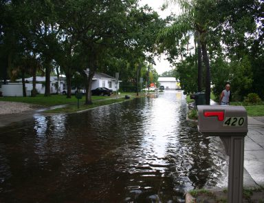
Recent federal updates to Region III’s Coastal Flood Map will require Anne Arundel County homeowners added to a special flood hazard area to buy flood insurance, while payments may decrease for those no longer in high-risk areas.
In a flood risk open house to be held on Tuesday, Sept. 9, area homeowners may speak with FEMA staff members and flood mapping experts about the recent updates to flood risk maps, well as any changes to their insurance policies.
Each year, the Federal Emergency Management Agency reissues locally specific Flood Insurance Risk Maps to chart risk at the property level.
Find out what's happening in Annapolisfor free with the latest updates from Patch.
Adopting and enforcing these revised maps allows Anne Arundel County to provide flood insurance to the homeowners, renters, and business owners in its communities through the National Flood Insurance Program. Through this program, FEMA has established community regulations that help minimize flooding, mitigate flood-related damage, and expedite recovery.
Tuesday night’s event, hosted by the Anne Arundel County Department of Planning and Zoning and the City of Annapolis, will take place from 6 to 8 p.m. in the South River High School cafeteria in East Edgewater at 201 Central Avenue.
Find out what's happening in Annapolisfor free with the latest updates from Patch.
Interactive flood risk mapping resources are published here, while more information about the upcoming open house can be found on Annapolis’ city website.
Get more local news delivered straight to your inbox. Sign up for free Patch newsletters and alerts.