Weather
Fred's Remnants Forecast To Bring MD More Rain This Week
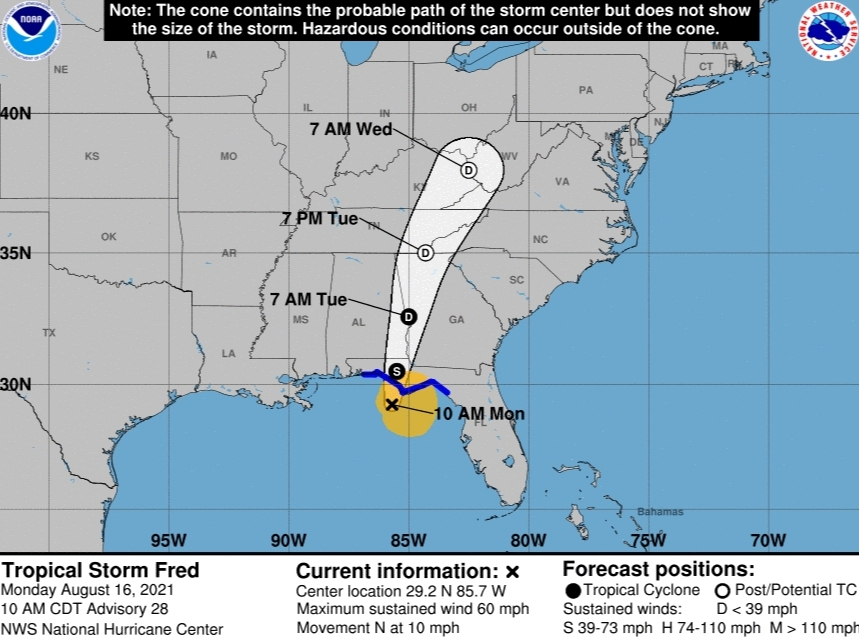
The remnants of Tropical Storm Fred could reach Maryland by Wednesday with some severe thunderstorms, and 2 to 6 inches of rain, possible.

MARYLAND — What's left of Tropical Storm Fred will bring showers and thunderstorms to Maryland this week, the National Weather Service says. Several counties are under a hazardous weather outlook Monday, which could bring unneeded rain, but the remnants of Fred will arrive midweek.
Fred is expected to turn to the north Monday and the center of storm will move across the eastern and northern Gulf of Mexico before making landfall in the western Florida Panhandle later in the day Monday, according to the National Hurricane Center.
At 10 a.m. Monday, Fred was about 55 miles southwest of Apalachicola, Florida, with maximum sustained winds of 60 mph. After landfall, Fred is expected to quickly weaken.
Find out what's happening in Annapolisfor free with the latest updates from Patch.
The remnants of Fred could make it to Maryland by Wednesday with showers and thunderstorms possible in the region. Isolated severe thunderstorms are possible Wednesday and Wednesday night in association with Fred, the National Weather Service said.
Portions of the Mid-Atlantic states could receive 2 to 4 inches of rain with isolated maximum storm totals of 6 inches expected as Fred interacts with a nearby front, the National Hurricane Center said.
Find out what's happening in Annapolisfor free with the latest updates from Patch.
"Heavy rainfall across portions of the Southeast and Mid-Atlantic States could lead to flash, urban, small stream and isolated river flooding impacts," the NHC briefing Monday said.
All or parts of Baltimore, Prince George's, Anne Arundel, Charles, St. Marys, Calvert, Montgomery, Howard and Harford counties are under a hazardous weather outlook on Monday.
The National Oceanic and Atmospheric Administration is predicting a busier-than-average Atlantic hurricane season, which runs from June 1 to Nov. 30.
NOAA predicted 15 to 21 named storms, with seven to 10 becoming hurricanes.
Researchers from Colorado State University,who provide storm predictions for the season each April, revised their forecast on Aug. 5, have also predicted a busy storm season.
University researchers are now predicting 18 named storms, up from 17 in their April forecast, including the five named storms that have already occurred. They anticipate eight hurricanes, four of which will be Category 3 or higher.
See related stories:
- Above-Normal 2021 Atlantic Hurricane Season Predicted By NOAA
- 2021 Hurricane Season Names: From Ana And Bill To Sam And Wanda
This will make 2021 the sixth straight year of an above-average Atlantic hurricane season. The record 2020 season had 30 named storms, 12 of which made landfall.
The increases are based on a lack of any El Niño conditions, which typically reduce Atlantic hurricane activity.
Here's the full Maryland forecast:
Monday: A chance of showers, with thunderstorms also possible after 3pm. Mostly cloudy, with a high near 82. Southeast wind 5 to 7 mph. Chance of precipitation is 40%.
Monday night: Showers likely and possibly a thunderstorm. Mostly cloudy, with a low around 72. Southeast wind 3 to 7 mph. Chance of precipitation is 60%. New rainfall amounts between a quarter and half of an inch possible.
Tuesday: Showers likely and possibly a thunderstorm before noon, then a chance of showers and thunderstorms after noon. Mostly cloudy, with a high near 86. Southeast wind 3 to 7 mph. Chance of precipitation is 60%. New rainfall amounts between a tenth and quarter of an inch, except higher amounts possible in thunderstorms.
Tuesday night: A chance of showers and thunderstorms, mainly after 3am. Mostly cloudy, with a low around 73. South wind 3 to 6 mph. Chance of precipitation is 30%.
Wednesday: A chance of showers and thunderstorms, then showers likely and possibly a thunderstorm after 3pm. Mostly cloudy, with a high near 85. South wind 3 to 8 mph. Chance of precipitation is 60%.
Wednesday night: Showers and possibly a thunderstorm. Low around 73. Chance of precipitation is 80%.
Thursday: Showers likely, with thunderstorms also possible after 3pm. Partly sunny, with a high near 88. Chance of precipitation is 70%.
Thursday night: Showers likely and possibly a thunderstorm before 9pm, then a chance of showers and thunderstorms between 9pm and 3am, then a chance of showers after 3am. Mostly cloudy, with a low around 72. Chance of precipitation is 70%.
Friday: A chance of showers, with thunderstorms also possible after 3pm. Mostly sunny, with a high near 87. Chance of precipitation is 40%.
Friday night: A chance of showers and thunderstorms before 9pm. Partly cloudy, with a low around 70. Chance of precipitation is 40%.
Saturday: A chance of showers and thunderstorms. Mostly sunny, with a high near 88. Chance of precipitation is 40%.
Get more local news delivered straight to your inbox. Sign up for free Patch newsletters and alerts.