Weather
Helene Moves North: How Storm Could Impact MD Weekend Forecast
Remnants of Hurricane Helene, which made landfall as a powerful Category 4 storm, will linger over the Baltimore region in the coming days.

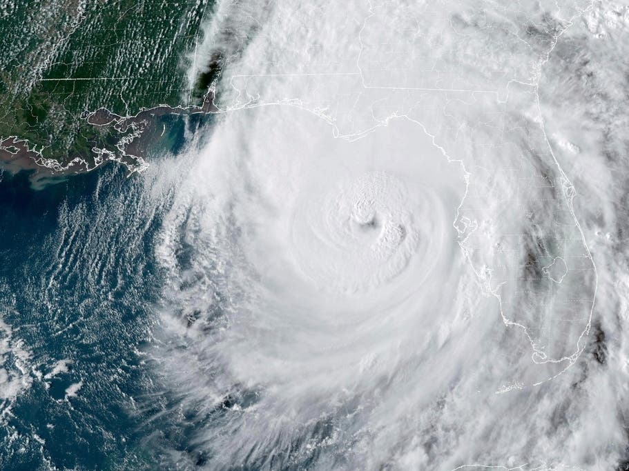
BALTIMORE, MD — After making landfall in Florida's Big Bend region as a powerful Category 4 hurricane, the remnants of Helene pushed north Friday and will likely bring numerous showers and coastal flooding to the Baltimore-DC region this weekend.
Helene weakened to a tropical storm over Georgia with maximum sustained winds of 70 mph early Friday, the National Hurricane Center said. The storm will continue to weaken as it moves north across Georgia and South Carolina, forecasters said.
While the Baltimore area is likely too far north to experience the most damaging impacts of Helene, the storm's remnants are still expected to bring rain showers, thunderstorms and heavier downpours to the region on Friday.
Find out what's happening in Annapolisfor free with the latest updates from Patch.
"Some showers will reach Chicago, Detroit, Philadelphia and perhaps New York City, Pittsburgh and Washington, D.C., but not Boston, and probably not Buffalo, New York," Accuweather said. "Along the mid-Atlantic coast to part of the central Appalachians, the moisture may be more in the form of drizzle and intermittent light rain."
A hazardous weather outlook was in effect Friday for the Maryland portion of the Chesapeake Bay, the Tidal Potomac River, and the I-95 corridor through central Maryland, northern Virginia, and District of Columbia, according to the National Weather Service.
Find out what's happening in Annapolisfor free with the latest updates from Patch.
A coastal flood watch will also go into effect at 8 p.m. Friday for the shoreline in Anne Arundel County and will continue through the remainder of the night.
Moderate coastal flooding is possible at times, NWS forecasters said.
An isolated tornado was also possible late Friday morning through early evening, especially across extreme southern Maryland as well as around King George and Spotsylvania Counties in central Virginia, according to the NWS.
In its latest forecast, the Capital Weather Gang said showers and a few periods of light-to-moderate rain are likely throughout Friday. The chance for downpours and thunderstorms should wait until after 4 p.m.
"If strong to severe storms develop — even with a quick tornado or two — they should mainly stay south of the Beltway," the Capital Weather Gang said.
Drier conditions and sunshine will make for a more pleasant Saturday before rain and thunderstorms likely return Saturday night into Sunday.
Related:
Here's a look at the detailed NWS weekend forecast for the Baltimore area:
Friday: Showers, mainly after 4pm. High near 76. East wind 6 to 10 mph, with gusts as high as 22 mph. Chance of precipitation is 80%. New precipitation amounts of less than a tenth of an inch possible.
Friday Night: Showers and thunderstorms before 1am, then scattered showers between 1am and 2am, then scattered showers and thunderstorms after 2am. Low around 72. East wind 7 to 11 mph, with gusts as high as 21 mph. Chance of precipitation is 80%. New rainfall amounts between a quarter and half of an inch possible.
Saturday: Scattered showers and thunderstorms. Cloudy, then gradually becoming mostly sunny, with a high near 84. Southeast wind 6 to 8 mph. Chance of precipitation is 30%.
Saturday Night: Scattered showers. Increasing clouds, with a low around 69. East wind around 6 mph. Chance of precipitation is 40%.
Sunday: Scattered showers. Cloudy, with a high near 77. East wind 6 to 9 mph. Chance of precipitation is 50%.
Sunday Night: Showers likely. Cloudy, with a low around 66. Chance of precipitation is 60%.
Get more local news delivered straight to your inbox. Sign up for free Patch newsletters and alerts.