Weather
Maryland Hurricane Season 2017 Could Be Worse Than Usual: Forecast
The most recent hurricane forecast conflicts with another one released last month, saying Maryland could be in the line of fire this year.

A new forecast says the 2017 hurricane season could be worse than normal — and the potential impact on Maryland could be increasingly troublesome. Both the Weather Channel and the National Weather Service say the 2017 Atlantic hurricane season, which begins June 1 and ends Nov. 30, will be more active than usual, and the number of named storms and hurricanes should be higher than usual.
The report conflicts with the 2017 Atlantic forecast released last week from Colorado State University, which says the number of named storms and hurricanes will likely be below historical averages.
Watch: 'Above-Normal' Atlantic Hurricane Season Expected
Find out what's happening in Annapolisfor free with the latest updates from Patch.
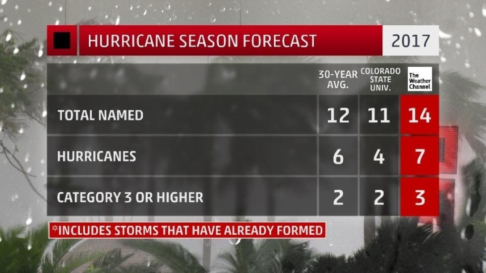
A total of 14 named storms — seven hurricanes and three major hurricanes — are expected this season, which is higher than the 30-year average (1981-2010) for the Atlantic basin, according to The Weather Channel. It would be a slight drop from last year, when there were 15 named storms, seven hurricanes and four major hurricanes.
A forecast released May 25 by the National Oceanic Atmospheric Administration calls for:
Find out what's happening in Annapolisfor free with the latest updates from Patch.
- Eleven to 17 named storms – including April's Tropical Storm Arlene.
- Five to 9 of which would become hurricanes.
- Two to 4 of which would become major hurricanes.
The 30-year historical average (1981-2010) for the Atlantic Basin is 12 named storms, six hurricanes and three major hurricanes. A major hurricane is one that is Category 3 or stronger on the Saffir-Simpson Hurricane Wind Scale.
Colorado State University expects four of the 11 named storms will become hurricanes, with two likely to reach major hurricane status.
Putting it in context, however, 2016 was the costliest season since 2012, and it was the deadliest since 2008, according to forecasters.
While Maryland has suffered few direct hits over the past 100 years — the most notable being Superstorm Sandy in 2012 — the National Weather Service says the state should be increasingly worried about the potential impact of these storms.
Given the current trends, there is the potential for another increase with the next update in June. "The historically strong North Atlantic blocking event in early May also suggests the possibility of continued increases in North Atlantic sea-surface temperature anomalies, so it would be no surprise if we increased our forecast numbers again," said Dr. Todd Crawford, chief meteorologist with The Weather Company.
»See also: 2017 Hurricane Names - Is Yours On The List?
The 2016 Maryland hurricane season was a snooze, luckily, with only Hurricane Hermine threatening the state the first week of September, and it veered into the Atlantic Ocean before reaching the Washington, D.C., and Baltimore region.
Even if the storms don't hit Maryland directly, the rising sea levels caused by climate change could cause a devastating flooding impact on the state — even if the storm lands as far south as South Carolina and Florida, according to the NWS.
"Climate change exacerbates any flooding concerns," said Joe Miketta, meteorologist with the National Weather Service. "We could have an increase in the potential for problems."
The Weather Company increased its forecast compared to the one issued in April because of a couple of factors:
- Warmer sea-surface temperatures have been observed in the North Atlantic, which have correlated with more active seasons in the past. In addition, there are indications that further warming is likely.
- There is a reduced potential for the development and strength of El Niño later this summer.
Given the current trends, according to The Weather Channel, there is the potential for another increase with the next update in June.
"The historically strong North Atlantic blocking event in early May also suggests the possibility of continued increases in North Atlantic sea-surface temperature anomalies, so it would be no surprise if we increased our forecast numbers again," Todd Crawford, chief meteorologist with The Weather Company, said on the website.
The season peaks each year between mid-August and mid-October. The period is described as the “season within the season” by forecasters. This eight-week period “is often the most active and dangerous time for tropical cyclone activity,” NOAA explained on its website.
The eight-week period is historically responsible for major spikes in tropical weather activity, NOAA said. In fact, it accounts for about 78 percent of all tropical storm days on record. It is also the period when 87 percent of the Category 1 and 2 hurricane days on record occurred. In addition, this period is responsible for “a whopping 96 percent of the major (Category 3, 4 and 5) hurricane days.”
The CSU team has been issuing annual hurricane prediction reports since 1984 under the direction of William Gray. Gray, a notable hurricane expert, continued to work on the reports until his death last year. CSU intends to issue updates to its 2017 forecast on June 1, July 3 and Aug. 2.
Maryland Hurricane History
To find out more about hurricane season and storm preparation, read these related Patch stories:
- Remember Agnes? 14 Maryland Hurricane Names You May Want To Forget
- Hurricane Tips If Storm Hits Maryland
Maryland has been spared "the big one" on most occasions, but for roughly 60 years, named hurricanes have battered our water-oriented state, altering our lifestyles and our history.
Hurricanes Connie and Diane pounded Maryland in October 1955. Just days apart in their torture on the East Coast, the storms caused widespread flooding. Connie essentially came right up the Bay.
Meanwhile, Diane came on land near the Carolina border and turned east to pass over northern Maryland before going back out to sea. More recently, Hurricane Sandy in October of 2012 made landfall just north of the upper Chesapeake Bay region, and destroyed the Ocean City fishing pier. From there it went on to devastate oceanfront areas of New Jersey and New York.
Hurricane Isabel in September of 2003 dealt a massive blow to Anne Arundel County and caused historic damage to downtown Annapolis. The storm struck the Mid-Atlantic region between Sept. 18-19, 2003. With 500 miles of shoreline, Anne Arundel County was among the hardest hit counties in the state. A total of 15 local businesses and more than 570 homes were declared uninhabitable from major flood damage, according to the report. There were approximately 100 structural collapses throughout the county.
The City Dock area became a giant swimming pool. Local residents kayaked and canoed through the streets, Patch reported later.
Residents readying for the upcoming season can get tips and advice on the federal government’s Ready.gov website.
To read the full 2017 Atlantic hurricane season prediction report, visit CSU online. To keep up with potential storm activity, bookmark the National Hurricane Center’s website. For local weather and severe weather alerts, visit the National Weather Service online.
Includes reporting by Patch Editors Sherri Lonon and Tom Davis
Patch file photo
Get more local news delivered straight to your inbox. Sign up for free Patch newsletters and alerts.