Weather
8 Inches Of Snow Possible In Anne Arundel County; School Changes
Snowfall estimates have doubled and travel could be impossible Sunday in Anne Arundel County, plus changes to Sunday school events.


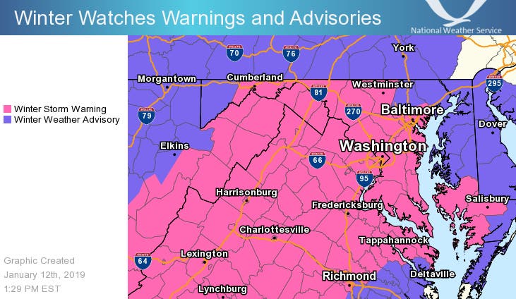
ANNAPOLIS, MD — Snowfall estimates have skyrocketed for the winter storm headed to Anne Arundel County. According to the National Weather Service, there's a strong likelihood of heavy snow into Sunday, Jan. 13. The area is under a winter storm warning that started at 7 p.m. Saturday and runs until 6 p.m. Sunday. Drivers are urged to stay home, and school events have been canceled for Sunday.
Anne Arundel County and southern Baltimore County are now projected to get about 3 to 7 inches of snow, according to the National Weather Service; that's more than double the projections on Thursday calling for 1 to 3 inches. Snow started Saturday afternoon and should continue falling through Sunday.
Snow-covered and slippery roads from the storm could make weekend travel very hazardous or impossible, the weather service warns. "If you must travel, keep an extra flashlight, food and water in your vehicle in case of an emergency. The latest road conditions for the state you are calling from can be obtained by calling 5 1 1," the NWS says.
Find out what's happening in Annapolisfor free with the latest updates from Patch.
Due to the expected heavy snow overnight and through most of Sunday, all school-sponsored activities for Sunday, Jan. 13, are canceled. No decision on the status of school operations for Monday, Jan. 14, has yet been made, officials said Saturday night.
Anne Arundel County Emergency Management officials urge residents to stay home and let first responders do their jobs. If you must travel during the storm, leave plenty of room between you and other vehicles and reduce your speed.
Find out what's happening in Annapolisfor free with the latest updates from Patch.
During the storm be sure to:
- Dress warmly. Wear multiple layers of thin clothing instead of a single layer of thick clothing.
- Properly vent kerosene heaters and keep any electric generators outside and away from open windows or doors to prevent carbon monoxide poisoning. Never burn charcoal or operate grills indoors.
- Monitor changing forecasts and weather conditions.
- Keep an emergency kit in your vehicle. Include scraper, jumper cables, tow chain, sand/salt, blankets, flashlight, first aid kit and road map.
- Check on neighbors.
- Bring pets inside.
For more information on how to prepare for winter storms, visit the Anne Arundel County website.
Warming centers will remain open overnight from Saturday, Jan. 12, at 6 p.m. until Monday, Jan. 14, at 9 a.m. in response to cold temperatures and low wind chills. Temperatures are forecast to be in the low 20s with gusty winds, creating wind chill values in the teens.
These Anne Arundel County Police District Station Community Rooms will be open as warming centers:
- Northern District: 939 Hammonds Lane, Baltimore
- Eastern District: 204 Pasadena Rd, Pasadena
- Western District: 8273 Telegraph Road, Odenton
- Southern District: 35 Stepneys Lane, Edgewater
Monday morning commutes and school openings may be affected, according to the Maryland Emergency Management Agency; below-freezing temps Sunday night may leave "lingering impacts of the storm in certain areas," MEMA advised.
The Maryland Department of Transportation State Highway Administration has positioned crews across the state to respond to through Sunday. Crews pretreated roads with salt brine and have snow removal equipment and supplies ready for use.
“We urge motorists to limit travel so that crews can safely treat roadways effectively,” said Maryland Department of Transportation State Highway Administrator Greg Slater in a news release. “We will be working through the night and through the duration of the storm to keep the roads safe.”
The heaviest snow is expected to fall in southern Maryland and the lower Eastern Shore, the agency said. MDOT SHA and contractor crews will continue to work until all lanes and shoulders are clear. Drivers are asked to limit travel and get errands complete before the storm begins late Saturday.
Central Maryland may receive 3 to 6 inches of snow, Western Maryland may get more and the Eastern Shore will receive up to 1 inch of snow mixed with rain and/or sleet, according to MEMA.
Higher snowfall totals are expected in southern Maryland. St. Mary's County is under a winter storm watch from Saturday afternoon to Sunday morning. At least 5 inches of snow may fall there.
Here are the snowfall predictions from the National Weather Service for 7 a.m. on Saturday, Jan. 12, to 7 p.m. on Sunday, Jan. 13:
- Baltimore Inner Harbor: 3 inches expected; low of 1 inch, high of 5 inches
- D.C., National Mall: 3 inches expected; low of 1 inches, high of 6 inches
- Frederick: 3 inches expected; minimum of 1 inches, high of 5 inches
- Hagerstown: 3 inches expected; low of 2 inches, high of 5 inches
- Leonardtown: 5 inches expected; low of 2 inch, high of 6 inches
These estimates are preliminary; see the latest projections from the National Weather Service.
A Winter Weather Advisory for snow means periods of snow will cause primarily travel difficulties. Expect snow covered roads and limited visibilities, and use caution while driving.
Forecast
Here is the latest forecast for Anne Arundel County from the National Weather Service:
Saturday: Snow likely, mainly after 5pm. Cloudy, with a high near 34. Light southeast wind. Chance of precipitation is 60%. Total daytime snow accumulation of less than a half inch possible.
Saturday Night: Snow. Low around 29. East wind 5 to 7 mph. Chance of precipitation is 100%. New snow accumulation of 1 to 3 inches possible.
Sunday: Snow. High near 35. Northeast wind 9 to 14 mph, with gusts as high as 22 mph. Chance of precipitation is 100%. New snow accumulation of 1 to 2 inches possible.
Sunday Night: Snow likely, mainly before 11pm. Cloudy, with a low around 25. Northeast wind 8 to 13 mph, with gusts as high as 22 mph. Chance of precipitation is 60%. Little or no snow accumulation expected.
Monday: Partly sunny, with a high near 36. North wind 5 to 9 mph.
Photo via Shutterstock; graphic by the National Weather Service
Get more local news delivered straight to your inbox. Sign up for free Patch newsletters and alerts.