Weather
Tropical Storm Isaias Could Reach Maryland By Tuesday
A new tropical storm formed late Wednesday night, and it could hit Maryland by Tuesday. Strong winds threaten the U.S. East Coast.


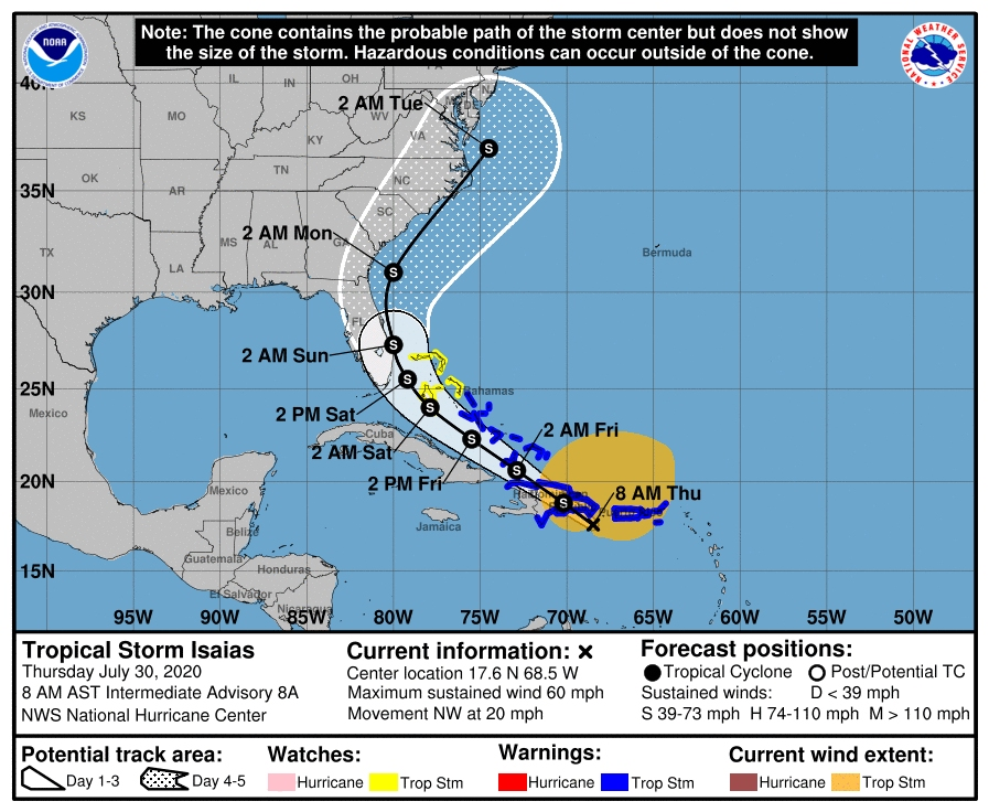
ANNAPOLIS, MD — A new tropical storm could hit Maryland early next week, according to the National Hurricane Center. Tropical Storm Isaias formed late Wednesday night in the Atlantic, threatening to deliver heavy rain and strong winds to Florida, Georgia, South Carolina, North Carolina, Virginia, Maryland, Delaware and New Jersey beginning this weekend.
Isaias is expected to hit Maryland's eastern shore around 2 a.m. on Tuesday. The system is the ninth named storm this hurricane season.
"Isaias is moving toward the northwest near 20 mph," the National Hurricane Center said at 8 a.m. Thursday. "On the forecast track, the center of Isaias will move over Hispaniola later today and near the Southeastern Bahamas by tonight or early Friday."
Find out what's happening in Annapolisfor free with the latest updates from Patch.
The system is located about 125 miles west-southwest of Ponce, Puerto Rico, and about 102 miles southeast of Santo Domingo, Dominican Republic ,as of 8 a.m. Thursday. Tropical-storm-force winds extend outward up to 415 miles from the center.
Winds must reach at least 39 mph for a system to be considered a tropical storm. Sustained winds of 74 mph or more draw a hurricane categorization. Weather officials said Isaias packed maximum sustained winds near 60 mph, as of 8 a.m. Thursday.
Find out what's happening in Annapolisfor free with the latest updates from Patch.
A tropical storm warning is in effect for parts of Puerto Rico, the U.S. Virgin Islands, the British Virgin Islands, the Dominican Republic, Haiti, Turks and Caicos and the Bahamas. A tropical storm watch looms over other parts of the Bahamas.
Places expected to experience tropical storm conditions within 36 hours warrant a tropical storm warning. Locations that could see a tropical storm within 48 hours fall under a tropical storm watch.
The storm's track shifted eastward in the 11 p.m. Wednesday update, removing parts of the Florida Panhandle and all of Alabama from the possible path of Isaias for the time being.
The system may dump heavy rains and potentially life-threatening flash floods across the Virgin Islands, Puerto Rico, northern Haiti, the Bahamas and the Dominican Republic before making its way to the U.S. East Coast.
Warning Coordination Meteorologist Robert Molleda with the National Weather Service in Miami earlier said tropical storm force conditions could reach South Florida Friday night or early Saturday morning, but that could change.
"Even a very small change in the track can make a pretty big difference in potentially how strong the storm could get, or even how weak it would get, if it stays over land for a long period of time," Molleda said. "Those things are still highly uncertain."
Isaias could bring 3 to 6 inches of rain to Puerto Rico and northern Haiti with isolated maximum totals of 10 inches.
It is expected to pour 4 to 8 inches on the Dominican Republic with some pockets getting up to 6 inches.
The British and U.S. Virgin Islands as well as the Turks and Caicos were expected to receive 3 to 6 inches while the Bahamas were forecast to collect 4 to 8 inches of rain. Cuba may see 2 to 4 inches with local totals of 6 inches.
"These rainfall amounts will lead to life-threatening flash flooding and mudslides, as well as potential riverine flooding beginning today," weather officials said. "Urban and small stream flooding is expected for the U.S. Virgin Islands, eastern Puerto Rico and Hispaniola."
"Little change in strength is anticipated until landfall in Dominican Republic later today, with re-strengthening forecast on Friday and Saturday," the National Hurricane Center said.
Forecasts predict that Isaias will weaken by the time it reaches Maryland's beaches. There is an 11 percent chance that Isaias is still categorized as a tropical storm when it hits Ocean City early Tuesday morning.
There's a 5 percent chance that winds hit 50 knots, or 58 mph, in Ocean City. The odds of it blowing hurricane-speed winds on Maryland are about 1 percent. Annapolis has a 1 percent chance of feeling tropical storm winds.
Some forecasts show the storm strengthening after it hits the Dominican Republic, but officials still remain conservative with their forecasts for the United States. More information from the National Hurricane Center is available here.
RELATED:
Florida Patch Editor Paul Scicchitano contributed reporting to this article.
Have a story idea? Please contact me at jacob.baumgart@patch.com with any pitches, tips or questions. Follow me on Twitter @JacobBaumgart and on Facebook @JacobBaumgartJournalist to stay up-to-date with the latest Anne Arundel County and Prince George's County news.
Get more local news delivered straight to your inbox. Sign up for free Patch newsletters and alerts.