Weather
State Of Emergency Declared In MD Ahead Of 'Remarkably Dangerous' Storm
Gov. Moore has declared a state of emergency in MD ahead of a storm bringing dangerous cold, significant ice and 10 to 18 inches of snow.

Updated at 2:15 p.m.
Gov. Wes Moore declared a state of emergency on Friday ahead of a massive winter storm that is expected to dump as much as 18 inches of snow on some parts of Maryland. The storm is also predicted to bring bitterly cold temperatures to the Baltimore region, with wind chills reaching as low as 10 degrees below zero.
Declaring a state of emergency allows for Maryland agencies and resources to be on standby during and after the storm, which is predicted to barrel into the state on Saturday and could leave residents feeling its effects for days.
Find out what's happening in Anne Arundelfor free with the latest updates from Patch.
At a news conference on Friday, Moore said he had reached out to the President Donald Trump administration and requested a federal emergency declaration.
"This winter storm has the potential to be remarkably dangerous, and it's not just going to impact Maryland," Moore said. "A storm of this size, of this magnitude, is one that needs to be taken very, very seriously."
Find out what's happening in Anne Arundelfor free with the latest updates from Patch.
A winter storm warning is in effect for most of Maryland, with the exception of the state's Eastern Shore. The warning encompasses Baltimore City and surrounding counties, including Montgomery, Baltimore, Anne Arundel, Prince George's, Howard and Harford. The warning is in effect from 11 p.m. Saturday until 4 a.m. Monday.
In the latest forecast update from the National Weather Service, the agency said snow will likely spread across the region Saturday night, becoming heavy at times with rates of 1 to 2 inches per hour possible.
Travel will be hazardous to near impossible, and at times may be life-threatening, throughout the weekend, said state officials, who urged Marylanders to avoid travel.
“Keeping our people safe is always our top priority, but local officials, law enforcement, and first responders cannot do it alone,” Moore said. “Do not travel unless it is absolutely necessary. Staying off the roads is essential to keeping routes clear for law enforcement, snow removal crews, and emergency responders so they can do their jobs without delay.”
A mix of sleet or freezing rain is expected Sunday, the National Weather Service said, with significant icing possible, especially south of Highway 50. Visibility of one-quarter mile or less is possible at times.
Sleet and freezing rain mixed in with the heavy snow will likely create hazardous driving conditions, forecasters said.
By Monday, Baltimore City could see 13 inches of snow on the ground. Nearby, predicted totals include more than 11 inches in Annapolis, nearly 14 inches in Bel Air, and 17 inches in Frederick and Westminster.
.jpg)
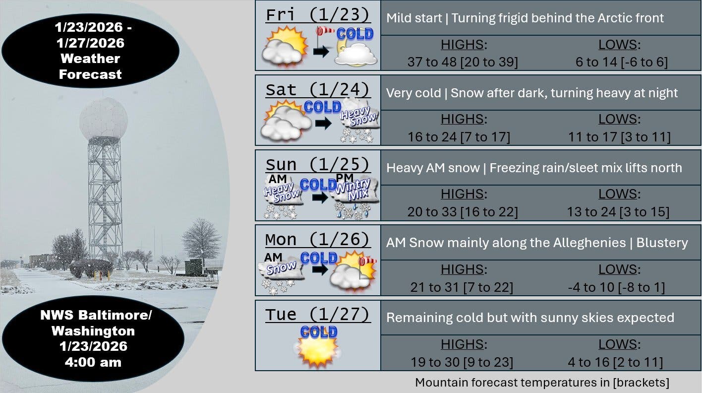
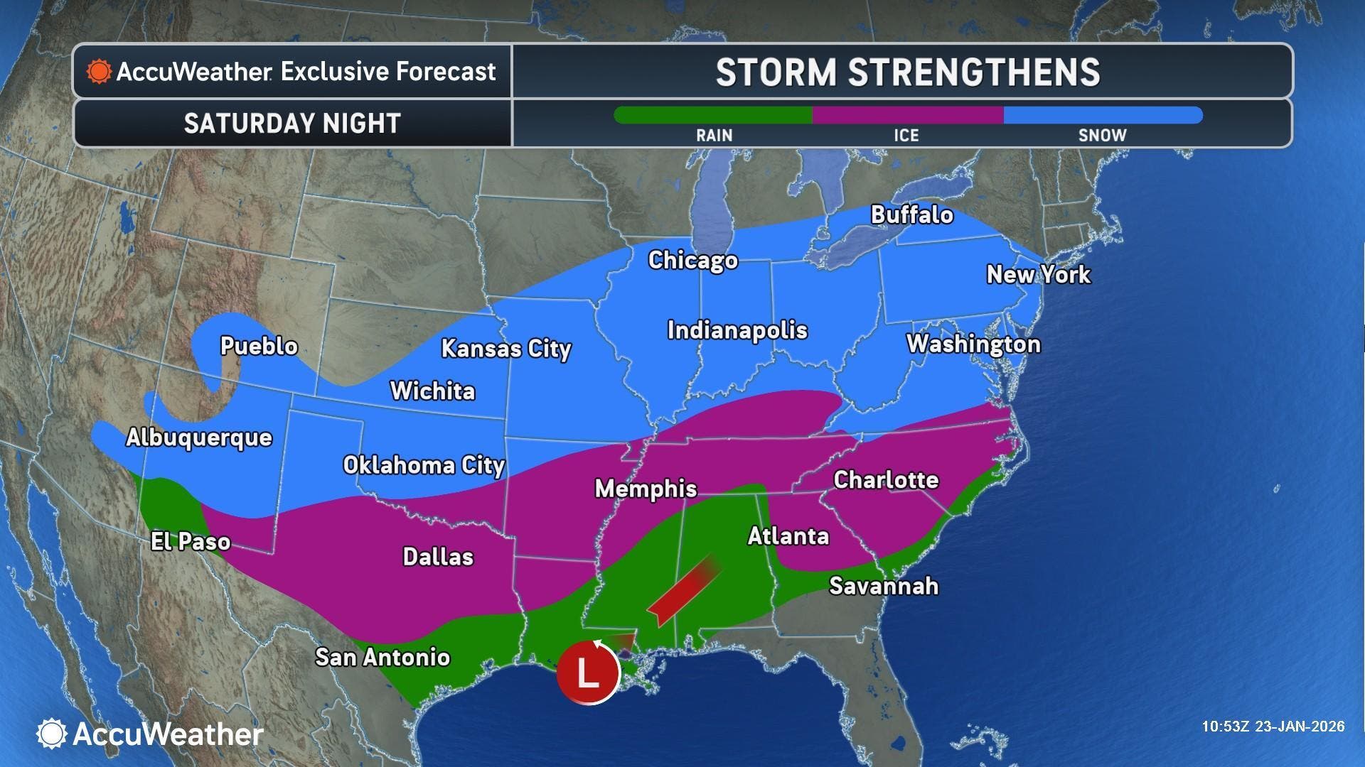
Here's what the agency said is coming to the Baltimore-DC region: "A large area of precipitation will overrun Arctic air in place over the Mid-Atlantic. This will likely lead to widespread significant snow beginning late Saturday, with the potential for ice Sunday, especially south of Highway 50 and near and east of Interstate 95.
"In addition to the high threat for significant snow and ice, very cold temperatures are expected Friday night through the middle of next week, with sub-zero wind chills likely at times."
.jpg)
Cold weather advisories have been issued across much of the area with actual temperatures expected to drop into the single digits Friday night, the National Weather Service said.
Areas included in the cold weather advisories are the District of Columbia, the city of Baltimore, and the counties of Cecil, Baltimore, Prince George's, Anne Arundel, Montgomery, Howard, and Harford.
The advisory is in effect from 8 p.m. Friday to 10 a.m. Saturday.
"A prolonged period of wind chills in the teens and single digits is likely beginning Friday evening and lasting through the middle of next week, with sub-zero wind chills possible at times," the National Weather Service wrote.
On Friday, Gov. Moore said that state officials and agencies were already making preparations for the storm and he urged Marylanders to do the same.
"What we need now is for everyone in the state of Maryland to understand the seriousness of this storm and be partners in ensuring everyone will be safe," Moore said. "This storm requires all Marylanders to do their part. Please stay off the roads. Please look after your neighbors. Please be advised, and when guidance is given, please follow."
Here's a look at the detailed National Weather Service for the Baltimore area:
Friday: Mostly cloudy, with a high near 40. West wind 11 to 15 mph, with gusts as high as 25 mph.
Friday Night: Partly cloudy, with a low around 9. Wind chill values as low as -5. Northwest wind 13 to 17 mph, with gusts as high as 28 mph.
Saturday: Increasing clouds, with a high near 21. Wind chill values as low as -6. North wind 6 to 10 mph.
Saturday Night: Snow before 4am, then snow, possibly mixed with sleet. The snow could be heavy at times. Low around 16. Northeast wind 3 to 6 mph. Chance of precipitation is 100%. New snow and sleet accumulation of 3 to 7 inches possible.
Sunday: Snow, possibly mixed with sleet before 10am, then snow, freezing rain, and sleet. The snow could be heavy at times. High near 27. Northeast wind 8 to 11 mph, with gusts as high as 21 mph. Chance of precipitation is 100%. New snow and sleet accumulation of 4 to 8 inches possible.
Sunday Night: Snow, freezing rain, and sleet before 10pm, then snow and freezing rain between 10pm and 4am, then a chance of snow after 4am. Low around 19. Chance of precipitation is 90%. New snow and sleet accumulation of 1 to 2 inches possible.
Monday: A chance of snow before 1pm. Partly sunny, with a high near 27. Chance of precipitation is 30%.
Monday Night: Mostly clear, with a low around 5.
Tuesday: Sunny, with a high near 24.
Get more local news delivered straight to your inbox. Sign up for free Patch newsletters and alerts.