Weather
Much Of Maryland Under Air Quality Alert; High Temps Forecast Too
Heat indices will reach 100 degrees Saturday, according to the National Weather Service.

MARYLAND — A code orange air quality alert is in effect for much of Maryland Saturday, June 29, as the heat wave continues. Heat indices Saturday may be 100 degrees, according to the National Weather Service. The agency also issued a hazardous weather outlook for the region, as Saturday may bring scattered thunderstorms with damaging wind gusts, large hail and heavy rain.
When officials declare a "code orange" for air quality, air pollution concentrations may become unhealthy for sensitive groups including children; older adults; and people with respiratory or heart ailments.
To minimize the effects of air pollution on their health, people in sensitive groups should avoid strenuous activities, such as outdoor exercise, when a code orange air quality alert is in effect.
Find out what's happening in Bel Airfor free with the latest updates from Patch.
The air quality alert applies to Baltimore City and Anne Arundel, Baltimore, Caroline, Carroll, Cecil, Dorchester, Harford, Howard, Kent, Queen Anne's, Somerset, Talbot and Wicomico counties. The Maryland Department of the Environment, which issued the alert, provides current air quality conditions online.
A hazardous weather outlook from the National Weather Service states that scattered thunderstorms Saturday afternoon may produce locally damaging wind gusts, large hail and heavy rain that could lead to flooding. One round of storms is expected late Saturday afternoon to evening in northern Maryland, eastern West Virginia and northern Virginia.
Find out what's happening in Bel Airfor free with the latest updates from Patch.
Heat Wave Continues Saturday
Temperatures will be in the low 90s Thursday through Sunday, according to the National Weather Service.
Saturday's hottest time is expected to be from 4 to 5 p.m., with an actual temperature of about 96 degrees and a heat index (what it feels like due to the combination of temperature and humidity) of 100 degrees.
Baltimore City has issued a code red, activating its cooling centers, and cooling centers have opened in Anne Arundel and Carroll counties as well.
The National Weather Service defines a heat wave as a period of abnormally and uncomfortably hot weather generally accompanied by humidity that lasts at least two days.
"An 'official' heat wave is defined as three or more consecutive days with the temperature reaching or exceeding 90 degrees," according to the weather service.
Here is the forecast for the Baltimore metro area from the National Weather Service:
Friday, June 28: Mostly sunny, with a high near 93 and low near 77. There is a 30 percent chance of isolated showers and thunderstorms from 3 to 9 p.m.
Saturday, June 29: Mostly sunny, with a high near 96 and low around 78. Heat index values of 100. West wind 5 to 11 mph. There is a 30 percent chance of showers and thunderstorms after 2 p.m.
Sunday, June 30: Mostly sunny, with a high near 91 and low around 70. Northwest wind 8 to 14 mph, with gusts as high as 23 mph.
Monday, July 1: Sunny, with a high near 87 and low around 72.
Tuesday, July 2: Mostly sunny, with a high near 92 and low around 73. There's a 30 percent chance of showers and thunderstorms.
Wednesday, July 3: Mostly sunny, with a high near 91.
Stay Safe in Heat
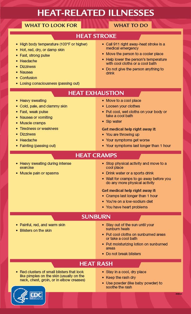
Heat-related illness is the number one weather-related killer, the National Weather Service reports.
Heat stroke, the most serious heat-related illness, can be fatal if not treated immediately. It occurs when the body's temperature rises rapidly and the sweating mechanism fails, leading to overheating without a way to cool down.
Symptoms of heat stroke include confusion; slurred speech; seizures; hot, dry skin or extreme sweating; altered mental status; very high body temperature; and loss of consciousness/coma. If someone exhibits signs of heat-related illness, move the person to a cool, shaded area and call 911.
Here are tips to stay safe in the heat:
- Reschedule strenuous activity to early morning or evening.
- Wear light and loose fitting clothing.
- Drink plenty of water.
- Take frequent breaks in the shade or an air-conditioned space if working outside.
- Do not leave children or pets unattended in cars.
- Know the signs and symptoms of heat exhaustion and heat stroke.
Get more local news delivered straight to your inbox. Sign up for free Patch newsletters and alerts.