Weather
Harford County Floods: Multiple Water Rescues Conducted
Multiple roads were flooded, and gauges indicated flooding at Deer Creek, according to the National Weather Service.

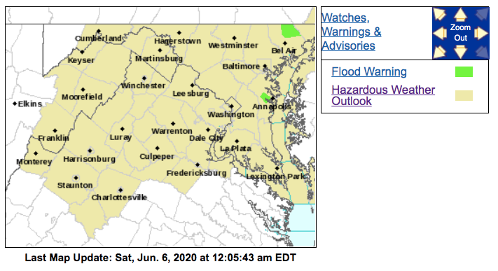
HARFORD COUNTY, MD — Multiple swift water rescue calls drew first responders to flooded Harford County roads Friday night, officials say. Northern Harford County was under a flood warning until 4 a.m. Saturday.
Floodwaters were traveling from Deer Creek toward Darlington, and Broad Creek was also experiencing flooding, the National Weather Service reported before midnight.
One person was reportedly trapped in swift water before 10:30 p.m. on Saint Claire Bridge Road off MD 24, according to Jenn Chenworth, spokeswoman for the Harford County Volunteer Fire and EMS Association. She said nobody was injured in that incident, which required assistance from both the fire department and the technical rescue team.
Find out what's happening in Bel Airfor free with the latest updates from Patch.
Two people who were trapped were also uninjured in a swift water rescue on a bridge in the 1500 block of Robinson Mill Road in Darlington, she reported at 10 p.m.
When encountering water-covered roads, people should turn around — don't drown. Officials advise most flood deaths happen in vehicles.
Find out what's happening in Bel Airfor free with the latest updates from Patch.
Officials said a number of roads in northern Harford County were impassable and closed after 10:30 p.m.
"Please avoid travel, if possible, and DO NOT drive through flooded roadways," Chenworth said. "We have had numerous water rescues in the Northern part of the county this evening that are continuing into the night."
By 6 p.m., water rescues were underway along Madonna Road near Telegraph Road and Grier Nursery at Glasgow Roads, according to Rich Gardiner, spokesman for the Harford County Volunteer Fire and EMS Association.
Law enforcement reported a water rescue near Jarrettsville before 5:40 p.m., and emergency management said there were several roads closed in the Norrisville area, according to the National Weather Service.
"Flash flooding is already occurring and will continue," the National Weather Service reported.
Up to 3 inches of rain had fallen in Harford County, the National Weather Service reported at 5:40 p.m. An additional 1 or 2 inches of rain were expected in the next hour, officials said, particularly in the Jarrettsville and Pylesville areas.
PREVIOUS REPORT (EXPIRED): Harford and Baltimore counties are under multiple weather alerts Friday night. A flash flood warning was in effect until 7:45 p.m. Flash flooding is a life-threatening rapid rise in water level, and the warning means it is imminent or occurring.
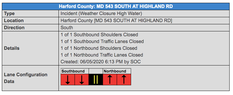
Several road closures were reported.
See the latest lane closure information here.

Pylesville, Darlington, Street, Cardiff, Scarboro and Whiteford may experience flooding, according to the weather service, which extended the flood warning after it had been set to expire at 8:15 p.m. and then midnight.
A flood warning means flooding is occurring or is imminent, and the warning through 4 a.m. is for northeastern Harford County.
Flood gauges indicated flooding along Deer Creek before 10 p.m., and water crested above major flood stage at Rocks State Park at 15 feet and was slowly falling.
These locations may get flooded, according to the warning: Jarrettsville, Pylesville, Darlington, Forest Hill, Cardiff, Chrome Hill, Norrisville, Street, Rocks, Scarboro and Whiteford. In particular, weather officials pointed out these flood-prone areas:
- Big Falls Road at Little Falls near Bernoudy Road
- Wiseburg Road at Little Falls near White Hall Road
- Walters Mill Road at Ady Road
- Shawnee Drive at Walters Mill Road
- Sandy Hook Road near Deer Creek
- Darlington Road at Deer Creek Road
Here are the latest road closures, according to state transportation officials:


Creeks and streams, urban areas, highways, streets and underpasses are vulnerable.
Flooding may impact these areas, according to the flash flood warning: Bel Air North, Fallston, Jarrettsville, Pylesville, Glencoe, Cardiff, Norrisville, Scarboro, Forest Hill, Chrome Hill, Bynum, Parkton, Phoenix, Street, Rocks, Maryland Line, Monkton, Hickory and Whiteford.
This includes flood prone locations such as the following, weather officials said
- Phoenix Road at Gunpowder Falls near Carroll Road
- Big Falls Road at Little Falls near Bernoudy Road
- Lower Glencoe Road at Gunpowder Falls near Glencoe
- Wiseburg Road at Little Falls near White Hall Road
- Old York Road at Little Falls near Hyde Road
- Walters Mill Road at Ady Road
- Shawnee Drive at Walters Mill Road
- Sandy Hook Road near Deer Creek
A flood warning was originally issued until 8:15 p.m. for northern Harford County and north-central Baltimore County and was later extended until midnight. The warning means flooding is imminent or occurring, according to the National Weather Service.
These areas may experience flooding, the warning states: Jarrettsville, Pylesville, Darlington, Glencoe, Freeland, Cardiff, Norrisville, Scarboro, Bentley Springs, Forest Hill, Chrome Hill, Parkton, Street, Rocks, Hereford, Maryland Line, Monkton and Whiteford.
A flash flood watch is in effect until midnight.
Get more local news delivered straight to your inbox. Sign up for free Patch newsletters and alerts.


