Weather
Winter Weather Advisory Extended In Harford County
A winter weather advisory has been extended in Harford County due to potentially hazardous conditions.


HARFORD COUNTY, MD — Harford County is under a winter weather advisory until 1 p.m. Tuesday, after the National Weather Service extended the advisory period that was to end at 10 a.m.
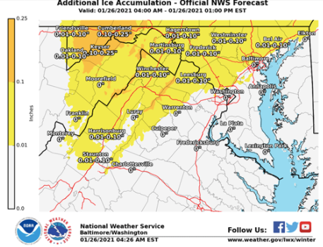
The advisory calls for freezing rain and additional ice accumulations of up to 0.1 inch that could lead to hazardous conditions.
Snowfall in Forest Hill has totaled about 0.4 inch, according to preliminary data released Tuesday morning. A trained spotter reported the measurement at 11:30 p.m. Monday, according to the National Weather Service.
Find out what's happening in Bel Airfor free with the latest updates from Patch.
See Also: Weather Closes HCPS Buildings Tuesday, January 26
"Hazards may linger into this afternoon as temperatures will only rise slowly this morning," the National Weather Service advised.
Find out what's happening in Bel Airfor free with the latest updates from Patch.
Drivers should decrease speed and pedestrians should be extra careful walking outside because of potentially slippery conditions. Power outages are also possible for the areas under the winter weather advisory, which applies to the following:
- Baltimore City
- Baltimore County
- Carroll County
- Cecil County
- Frederick County
- Harford County
- Howard County
- Montgomery County
Here are the preliminary snowfall totals around the state before 7:30 a.m. Tuesday: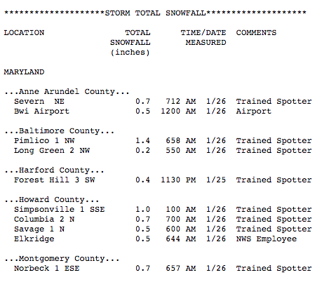
This is the forecast for Harford County from the National Weather Service:
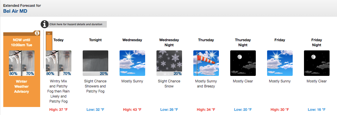
Tuesday: High near 37 and low of 32 degrees with patchy fog. Freezing rain, possibly mixed with sleet before 9 a.m., then freezing rain between 9 and 10 a.m., then rain likely after 10 a.m. Total daytime sleet accumulation of less than a half inch possible.
Wednesday: Mostly sunny, with a high near 43 and low around 26 degrees. Northwest wind 8 to 10 mph, with gusts as high as 18 mph. There is a 20 percent chance of snow at night.
Thursday: Mostly sunny, with a high near 34 and low around 20 degrees. Breezy, with a northwest wind 15 to 20 mph, with gusts as high as 31 mph.
Friday: Mostly sunny, with a high near 30 and low of 16 degrees.
Saturday: Mostly sunny, with a high near 33 and low around 20.
Sunday: There's a 40 percent chance of rain and snow. Mostly cloudy, with a high near 35 and low around 28.
Monday: Mostly cloudy, with a high near 38. There is a 50 percent chance of precipitation overnight Sunday and Monday.
Get more local news delivered straight to your inbox. Sign up for free Patch newsletters and alerts.