Weather
Heat, Severe Thunderstorm Alerts Issued Across Maryland
Storms may be on the way, after temperatures that felt like 110 degrees on Wednesday, July 17.

BALTIMORE, MD — Sweltering conditions and potentially damaging storms are in Wednesday's forecast for Maryland, according to the National Weather Service. Temperatures are expected to continue to rise through the weekend and could reach 100 degrees Saturday.
A severe thunderstorm watch is in effect until midnight for Anne Arundel, Baltimore, Calvert, Caroline, Carroll, Cecil, Charles, Harford, Howard, Kent, Montgomery, Prince George's, Queen Anne's and Talbot counties as well as Baltimore City. A watch means that conditions could lead to the development of severe thunderstorms.
A severe thunderstorm is one with winds of at least 58 mph and/or hail at least 1 inch in diameter, according to the National Weather Service's definition.
Find out what's happening in Bel Airfor free with the latest updates from Patch.
Radar showed a severe thunderstorm with 60 mph gusts near Taneytown before 5 p.m. on Wednesday, July 17, according to the National Weather Service.
Conditions also prompted the National Weather Service to issue a heat advisory for much of the state. A heat advisory means high temperatures and high humidity may cause heat-related illness.
Find out what's happening in Bel Airfor free with the latest updates from Patch.
The heat advisory is in effect from 11 a.m. to 8 p.m. on Wednesday, July 17. Heat indices will be 105 to 110 degrees Wednesday, while actual temperatures will be in the mid 90s, according to the National Weather Service. The heat index reflects the "feels-like" temperature outside, factoring in high temperatures as well as humidity.
Outdoor activities and extended exposure to the heat may cause heat stress and illness, the advisory states. Anne Arundel, Baltimore, Calvert, Caroline, Cecil, Charles, Dorchester, Harford, Howard, Kent, Montgomery, Prince George's, Somerset, St. Mary's, Talbot and Wicomico counties as well as Baltimore City are under the heat advisory.
A Heat Advisory has been issued for counties along/east of the I-95 corridor, including DC and Baltimore. Heat index values are expected to reach 105 degrees for areas in the advisory. #DCwx #MDwx #VAwx #WVwx pic.twitter.com/unclowshfB
— NWS DC/Baltimore (@NWS_BaltWash) July 17, 2019
Forecasters say the heat will not subside until after the weekend. In fact, the National Weather Service issued a hazardous weather outlook due to the prolonged period of excessive heat in the forecast through Sunday, July 21, with heat indices expected to top 100 each day until then.
Baltimore City has issued a code red heat alert through Sunday, meaning pools will be open later than usual and cooling centers are open. Anne Arundel and Montgomery counties have also opened cooling centers.
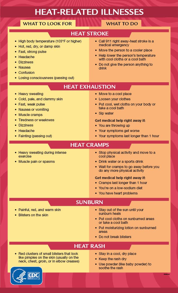
Preparing For Heat
Here are steps to stay safe during a heat advisory:
- Drink water and continue hydrating.
- Wear loose-fitting clothing.
- Stay in an air-conditioned space.
- Take frequent breaks if outside, cooling off in a shaded place.
- Reschedule strenuous activities for the early morning or evening.
Barry To Cause Heavy Rain, Flooding
Northern and northeastern Maryland may see damaging winds and flooding Wednesday afternoon and evening, according to the National Weather Service.
Cecil County is under a flash flood watch from 2 p.m. Wednesday to 1 a.m. Thursday as the remnants of Tropical Cyclone Barry move through the region.
Northeastern Maryland may see 2 to 4 inches of rain in a short period of time Wednesday afternoon and evening due to the anticipated torrential rainfall.
Heat Wave To Continue Through Sunday
This is the forecast for the Baltimore metro area from the National Weather Service:
Wednesday: Partly sunny with a high near 98 and low around 79. Heat index values as high as 109. Isolated showers and thunderstorms between 2 and 5 p.m., then showers likely and possibly a thunderstorm after 5 p.m. Chance of precipitation is 60%.
Thursday: Mostly cloudy, with a high near 94 and low near 78. Heat index values as high as 103. Scattered showers, with thunderstorms also possible from 8 a.m. to 8 p.m. Chance of precipitation is 50%.
Friday: Mostly sunny and hot, with a high near 99 and low around 83.
Saturday: Mostly sunny and hot, with a high near 101 and low around 84.
Sunday: Mostly sunny and hot, with a high near 100 and low near 82. A chance of showers and thunderstorms. Chance of precipitation is 30%.
Monday: Partly sunny, with a high near 92 and low of 74. Showers and thunderstorms likely. Chance of precipitation is 60%.
Tuesday: Partly sunny, with a high near 86. A chance of showers and thunderstorms. Chance of precipitation is 40%.
Check the latest local forecast from the National Weather Service.
Get more local news delivered straight to your inbox. Sign up for free Patch newsletters and alerts.