Weather
Maryland Weather: Bomb Cyclone To Make For Dangerous Commute
Dangerous travel conditions are forecast for Thursday, Jan. 4, leading the National Weather Service to issue winter weather advisories.

BALTIMORE, MD — Weather officials are advising Marylanders to prepare for a potentially dangerous commute Thursday morning as a winter storm forms in the Atlantic. What forecasters are calling a "bomb cyclone" is expected to deliver blizzard conditions along the East Coast, including Maryland's Eastern Shore. Various parts of the state may see snowfall from an inch to 12 inches, weather officials say.
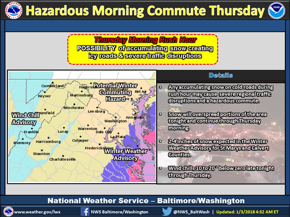
The National Weather Service has issued several winter weather advisories across Maryland to warn drivers of the potential for snow-covered and slippery roads and limited visibility. The advisories run from 10 p.m. Wednesday to 11 a.m. Thursday.
"Plan ahead and allow extra time to get to your destination if traveling late Wednesday night or Thursday," the advisories say. With the high temperature on Thursday in the mid 20s, weather officials advise that snow will stick to roads and sidewalks.
Find out what's happening in Bel Airfor free with the latest updates from Patch.

Find out what's happening in Bel Airfor free with the latest updates from Patch.
Calvert and St. Mary's counties are in for 3 to 5 inches of snow in a separate advisory as well.
In Cecil County, a winter weather advisory calls for 3 to 5 inches of snow and limited visibility, with wind gusts up to 40 mph. The advisory is effective from 9 p.m. Wednesday to 7 p.m. Thursday. Scattered power outages are possible.
There will be 6 to 10 inches of snow on the Eastern Shore in Somerset, Wicomico and Worcester counties, which are under a blizzard warning from 7 p.m. Wednesday to 1 p.m. Thursday. Locally higher amounts of 12 inches are possible.
"Travel will be very dangerous to impossible, including during the morning commute on Thursday," in the areas under the blizzard warning, officials say. Tree branches may fall.
And once the snow ends, the hazardous conditions remain.
"Bitterly cold conditions will follow for late Thursday through the weekend, causing snow to remain on untreated surfaces," according to the National Weather Service.
The snow coming to Maryland is a product of a storm called a "bomb cyclone" that may bring hurricane-force winds and polar vortex temperatures to the Eastern Seaboard. (Sign up for Patch emails for more weather alerts; find your local Patch here. If you have an iPhone, click here to get the free Patch iPhone app.)
What's a bomb cyclone? The term is new to the winter weather vernacular, which includes others like "polar vortex" that scare the living daylights out of people. And if this storm develops to its full potential, a healthy fear is in order. At its worst, it could carry hurricane force winds, blinding snow and a bomb-like drop in pressure. And after the snow exits, the temperatures will dip into the polar vortex range with some of the coldest air of what has, at just three days old, already been a bone-chilling year.
As summer hurricanes do, the storm is expected to gather strength off the coast of Florida Wednesday, where it may bring snow and ice to areas not accustomed to such weather, then move on to the New England coast, where some areas could see up to 8 inches of snow.
The fierce weather system has one airline warning travelers that flights to and from several cities could be cancelled or delayed Wednesday and Thursday as the storm makes its way up the eastern seaboard from Florida to Maine.
Delta Airlines is getting ahead of the storm, warning travelers the storm could cripple airports in Georgia, the Carolinas and Florida, which are expected to get ice and several inches of snow from the powerful storm system. That could snarl travel plans in the rest of the country as well.
See Also:
- MD Weather Forecast: Snow, Bitter Cold Spell On The Way
- What Is A Bomb Cyclone? Winter Storm Brews In Atlantic
PREVIOUS REPORT: The potential for snow-glazed roads on Thursday morning in the Baltimore-Washington area has prompted the National Weather Service to issue a special weather statement to alert Maryland commuters. There is a 60 to 70 percent chance of snow Wednesday night through Thursday morning, with snow most likely near and east of Interstate 95, weather officials said.
The storm, which is being called a "bomb cyclone," may bring hurricane-force winds and polar vortex temperatures to the Eastern Seaboard. The forecast calls for anywhere from a coating to an inch of snow to fall between 10 a.m. Wednesday and 10 a.m. Thursday in Anne Arundel, Baltimore, Carroll, Harford, Howard, Montgomery and Prince George's counties.
"If commuting Thursday morning, be aware of the POSSIBILITY of significant travel disruptions," the National Weather Service said in a special weather statement Wednesday morning. (Sign up for Patch emails for more weather alerts; find your local Patch here. If you have an iPhone, click here to get the free Patch iPhone app.)
"If this threat does materialize during the Thursday morning rush hour, many roads could quickly turn icy. This could lead to dangerous traveling conditions, multiple accidents and extensive delays," weather officials said.
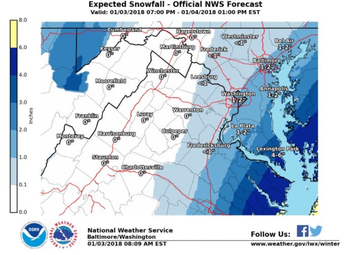
In Frederick and northwest Montgomery counties, the chance of snow was slightly less, officials said, with a 30 to 50 percent chance of snowfall in the forecast.
The track of the storm appears to be trending east. Calvert and St. Mary's counties are under a winter weather advisory from 10 p.m. Wednesday to 11 a.m. Thursday calling for 2 to 4 inches of snow.
The snow forecast from Wednesday to Thursday comes from an area of low pressure that is moving up the East Coast, producing a rain-sleet-snow mix in the southeast, snow in the mid-Atlantic and blizzard conditions as it reaches New England, according to the National Weather Service.
The fierce weather system meteorologists are calling a "bomb cyclone" has one airline warning travelers that flights to and from several cities could be cancelled or delayed Wednesday and Thursday as the storm makes its way up the eastern seaboard from Florida to Maine.
What's a bomb cyclone? The term is new to the winter weather vernacular, which includes others like "polar vortex" that scare the living daylights out of people. And if this storm develops to its full potential, a healthy fear is in order. At its worst, it could carry hurricane force winds, blinding snow and a bomb-like drop in pressure. And after the snow exits, the temperatures will dip into the polar vortex range with some of the coldest air of what has, at just three days old, already been a bone-chilling year.
As summer hurricanes do, the storm is expected to gather strength off the coast of Florida Wednesday, where it may bring snow and ice to areas not accustomed to such weather, then move on to the New England coast, where some areas could see up to 8 inches of snow.
Graphics via National Weather Service.
Get more local news delivered straight to your inbox. Sign up for free Patch newsletters and alerts.