Weather
MD Hazardous Weather: Storms To Bring Heavy Rain, 45 MPH Winds
A hazardous weather outlook has been issued for parts of Maryland, with a rainy weekend forecast that carries flood and wind risks.


BALTIMORE, MD — Potentially strong storms are expected to hit Maryland on Friday and Saturday – with winds possibly gusting up to 45 mph. While it will be unseasonably warm on Friday with a high in the mid-70s, that will give way to storms and much cooler temperatures the rest of the weekend, forecasters say.
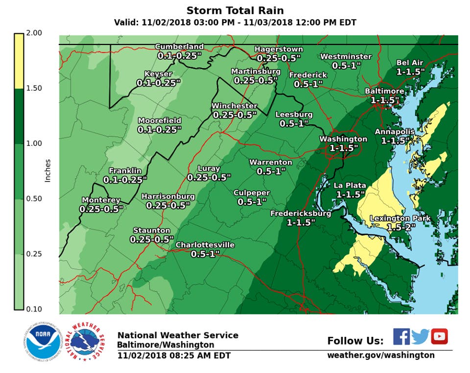
The National Weather Service has issued a hazardous weather outlook for parts of Maryland, the District of Columbia and northern Virginia, saying rain could be heavy enough to result in localized flooding Friday afternoon and evening. A total of 1-2 inches of rain should fall, but up to 3 inches is possible. Winds on Saturday are expected to gust to 35-45 mph.
The hazardous weather outlook has been posted for all or parts of Baltimore, Prince George's, Anne Arundel, Charles, St. Marys, Calvert, and Harford counties.
Find out what's happening in Bel Airfor free with the latest updates from Patch.
Brief wind gusts to near gale force may require special marine warnings over the waters late in the afternoon and Friday evening, the NWS says.
"Showers this morning will increase in coverage and intensity late this afternoon and overnight," the Baltimore-Washington offices of the National Weather Service says. "Heaviest rainfall is forecast along and east of the I-95 corridor where 1-2 inches is possible. Showers and isolated thunderstorms producing heavy rain may result in isolated instances of flooding."
Find out what's happening in Bel Airfor free with the latest updates from Patch.
The Weather Channel says there is some chance that strong to severe thunderstorms will spread toward the East Coast into Friday night, from southwestern New England to central Florida.
Damaging wind gusts and a tornado or two are possible with any storms that develop.
Sporadic power outages and tree damage may result, AccuWeather said. AccuWeather also said there could be an isolated tornado.
(For more news like this, find your local Patch here. If you have an iPhone, click here to get the free Patch iPhone app; download the free Patch Android app here. And like Patch on Facebook!)
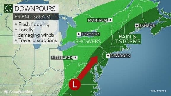
Indeed, back-to-back storms aiming at the Northeast, beginning Friday, could prevent the dry and mild weather that started November from south of Boston to New York City and Washington, D.C., from lasting, according to AccuWeather.
After some rain will fall on Friday, AccuWeather said soaking rain will spread from southwest to northeast along the Interstate 95 corridor from Friday afternoon into Saturday morning.
"This fast-strengthening storm will bring a range of impacts and likely lead to travel delays across the Northeast," AccuWeather Meteorologist Bill Deger said in a release.
Drivers will have to use caution as the heavy rain can lead to reduced visibility and a heightened risk of vehicles hydroplaning when traveling at highway speeds. Leaf-covered roads can turn slippery when wet, according to the release. The drenching rain may be accompanied by gusty winds and thunderstorms in some communities.
"While widespread severe weather is not expected, it is not out of the question some showers or thunderstorms could bring brief, strong wind gusts to the mid-Atlantic on Friday night and central and southern New England on Saturday," Deger said in the release.
Here is the forecast:
Friday: Scattered showers, then showers and possibly a thunderstorm after 3pm. Some of the storms could produce heavy rain. High near 75. Southwest wind around 10 mph. Chance of precipitation is 80%. New rainfall amounts between a quarter and half of an inch possible.
Friday Night: Showers and possibly a thunderstorm before 9pm, then showers likely. Some of the storms could produce heavy rain. Low around 52. Northwest wind 6 to 9 mph. Chance of precipitation is 90%. New precipitation amounts between three quarters and one inch possible.
Saturday: A slight chance of showers before noon. Cloudy through mid morning, then gradual clearing, with a high near 59. West wind 13 to 18 mph, with gusts as high as 28 mph. Chance of precipitation is 20%.
Saturday Night: Mostly clear, with a low around 40. Northwest wind 5 to 9 mph becoming calm after midnight.
Sunday: Sunny, with a high near 58. Calm wind becoming east around 5 mph in the afternoon.
Sunday Night: A chance of rain after 1am. Partly cloudy, with a low around 46. Chance of precipitation is 40%.
Image via Shutterstock
Get more local news delivered straight to your inbox. Sign up for free Patch newsletters and alerts.