Weather
Nicole Remnants To Bring Heavy Rain, High Winds To MD
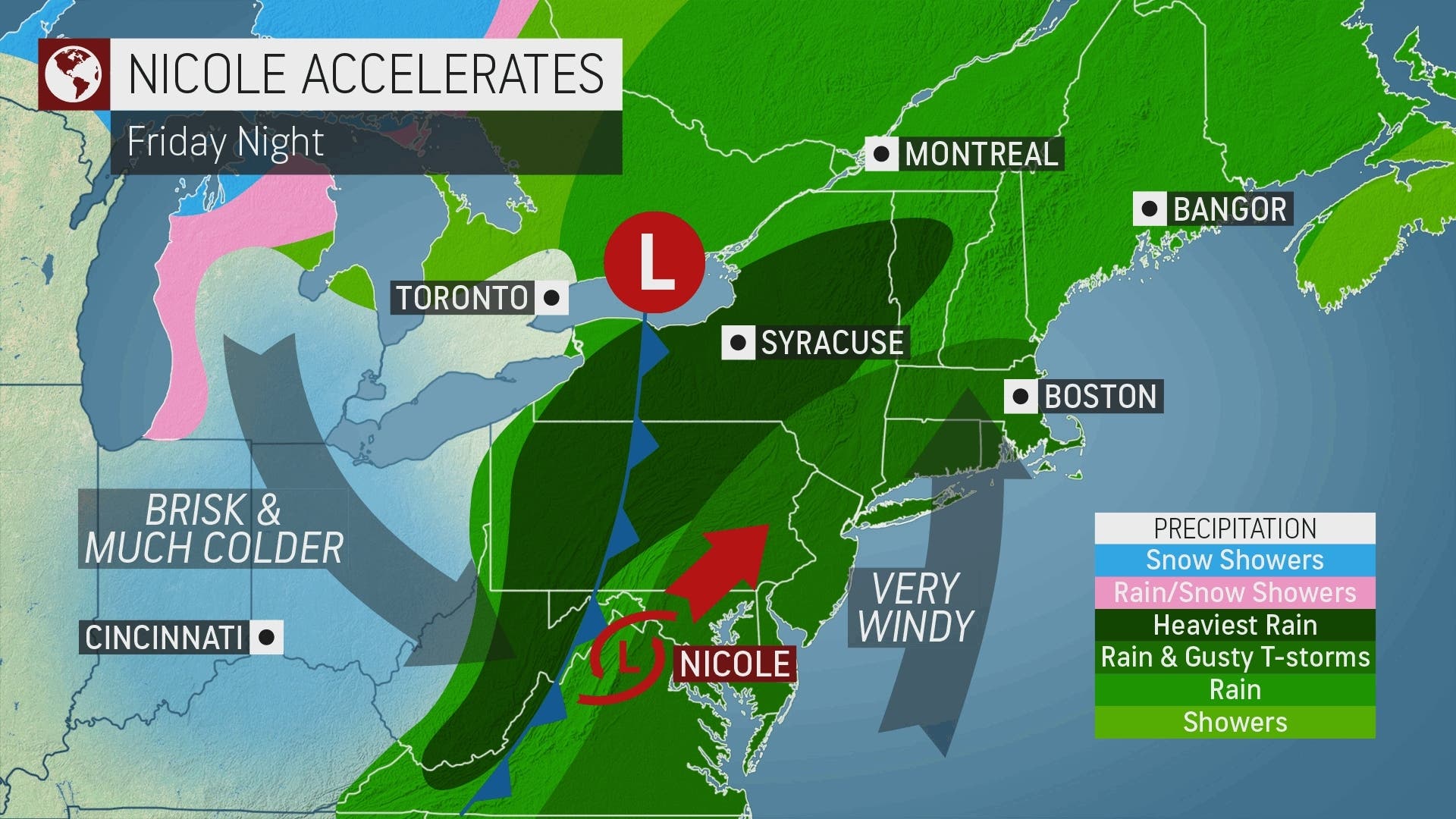
The remnants of Nicole could bring heavy rain and damaging winds to Maryland Friday into Saturday plus a risk of tornadoes.


MARYLAND — The remnants of what was is now tropical depression Nicole are expected to bring heavy and widespread rainfall, as well as damaging winds and the possibility of tornadoes to the Baltimore-DC region on Friday and into Saturday, forecasters said.
Some flooding and power outages are possible, weather forecasters warned.
"An active weather day ahead as the remnants of Nicole move through. It will be mild and humid, with bouts of moderate/heavy rain, as well as the potential for a few severe storms. Expect 1-2" of rain, locally around 2-4" from the Blue Ridge westward," the Baltimore-DC office of the National Weather Service tweeted.
Find out what's happening in Bel Airfor free with the latest updates from Patch.
The agency issued a hazardous weather outlook for the Maryland portion of the Chesapeake Bay, Tidal Potomac River, and I-95 corridor through central Maryland, northern Virginia, and District of Columbia.
A gale warning is in effect for the coastal waters from 3 p.m. through Friday night.
Find out what's happening in Bel Airfor free with the latest updates from Patch.
Isolated instances of flooding are possible through tonight.
Areas covered by the hazardous weather outlook include: the District of Columbia, plus Cecil, Baltimore, Prince George's, Anne Arundel, Charles, St. Marys, Calvert, Montgomery, Howard and Harford counties.
With Nicole's track well inland, thunderstorms erupting in the Interstate 95 corridor on Friday and Friday night could be potent enough to bring damaging wind gusts, Accuweather said.
Once Nicole moves into the mid-Atlantic, the strongest wind gusts are most likely to the east of the storm. Coastal locations will be particularly prone to wind gusts in excess of 40 mph for at least a 12-hour period.
The wind direction may change depending on Nicole's exact track, but an easterly or southerly wind is likely to hit beaches and inland bays from Virginia and Maryland to southern Maine for perhaps as long as 24 hours. The long duration of these winds can lead to above-normal tides, coastal flooding and beach erosion into the weekend.
Officials are urging residents to be cautious while driving, and to avoid roads altogether when covered with water. Accuweather meteorologists believe that "urban flooding is a certainty, especially where fallen leaves clog storm drains."
Tropical rain reached Baltimore, Washington, D.C. and Pittsburgh by the Friday morning rush hour and will continue to advance northeastward through Friday night, Accuweather said.
Widespread rainfall of 2-4 inches is likely from western Virginia through the eastern Ohio Valley, the Appalachians and into northern New England before rain comes to an end late Friday night or Saturday morning.
Pockets of more than 4 inches of rain are possible in eastern Ohio and in the mountainous terrain of Virginia.
Here's the latest weekend forecast:
Veterans Day: Showers and possibly a thunderstorm, mainly before 5pm, then a chance of showers and thunderstorms after 5pm. Patchy fog before 4pm, then patchy fog after 5pm. High near 70. Southeast wind 6 to 11 mph, with gusts as high as 23 mph. Chance of precipitation is 100%. New rainfall amounts between a quarter and half of an inch possible.
Friday Night: Showers and thunderstorms. Patchy fog between 3am and 4am. Low around 63. Southeast wind around 16 mph becoming southwest after midnight. Winds could gust as high as 38 mph. Chance of precipitation is 100%. New rainfall amounts between a quarter and half of an inch possible.
Saturday: A chance of showers, mainly before 7am. Cloudy through mid morning, then becoming mostly sunny, with a high near 69. West wind 11 to 15 mph, with gusts as high as 26 mph. Chance of precipitation is 30%.
Saturday Night: A chance of showers after 8pm. Mostly cloudy, with a low around 44. Northwest wind 8 to 10 mph. Chance of precipitation is 30%.
Sunday: A chance of showers before 8am. Mostly sunny, with a high near 51. Northwest wind 10 to 15 mph, with gusts as high as 23 mph. Chance of precipitation is 30%.
Sunday Night: Clear, with a low around 36.
Get more local news delivered straight to your inbox. Sign up for free Patch newsletters and alerts.


