Weather
Weather Alert For Harford County Canceled
The National Weather Service canceled its hazardous commuting alert.

Updated as of 8:34 a.m. Tuesday:
The National Weather Service canceled its alert for commuters Tuesday morning for the Baltimore metro area and northeastern Maryland.
After forecasting possibly slick conditions, officials said Tuesday that the threat had diminished. Dry conditions are expected.
Find out what's happening in Bel Airfor free with the latest updates from Patch.
HARFORD COUNTY, MD — Drivers could face slippery conditions during the Tuesday morning rush hour in parts of Maryland, including Harford County. A light wintry mix is possible, according to the forecast.
Roads may be glazed with ice or coated by snow, forecasters said, citing a 30 percent chance of freezing rain and light snow for the Baltimore metropolitan area and northeast Maryland.
Find out what's happening in Bel Airfor free with the latest updates from Patch.
Snow and freezing rain could arrive in Harford County after 4 a.m. Tuesday, when the low is about 26 degrees, based on the forecast. Snow, freezing rain and sleet are possible before 9 a.m., followed by a chance of rain from 9 a.m. to 1 p.m. The high will be 44 degrees Tuesday.
"This could lead to dangerous traveling conditions, multiple accidents, and extensive delays," the weather service said in a special weather statement. "Plan ahead by allowing for extra travel time, and consider using telework options."
The special weather statement applies to Baltimore City, Baltimore County, Carroll County, Cecil County, Frederick County and Harford County.
Tuesday is not the only time there may be wintry weather this week.
Wednesday night there is a "slight winter storm threat," and Thursday presents an "enhanced winter storm threat" during the day and evening, according to a hazardous weather outlook from the National Weather Service. Forecasters said those could create "more significant travel impacts and more closures."
Threats of snowfall this week come on the heels of multiple snow days, including 10 inches of accumulation reported in Norrisville Tuesday, Feb. 2, and 5 inches in Forest Hill reported Sunday, Feb. 7.
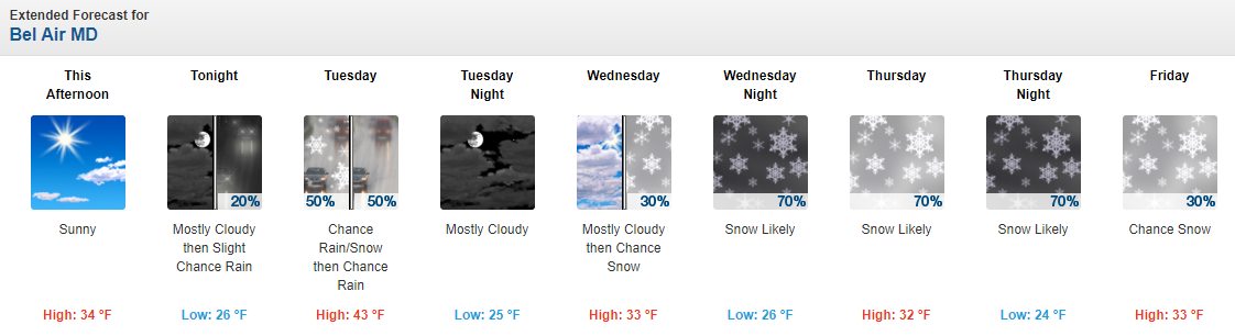
Here is the Bel Air forecast from the National Weather Service:
See Also:
- 20.5 Inches Of Snow: MD Town-By-Town Snow Totals From Multi-Day Storm
- MD Snow Totals From Sunday's Storm Lower Than Projected
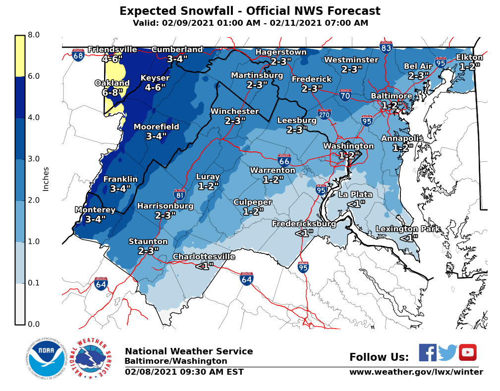
Here are snowfall projections for Tuesday to Thursday morning:
Get more local news delivered straight to your inbox. Sign up for free Patch newsletters and alerts.