Weather
Torrential Rain Likely In MD, Flash Flood Watch Extended
Up to 4 inches of rain is predicted to fall across Maryland into early Friday, prompting a flash flood watch to be extended.

BALTIMORE, MD — Flash flooding caused problems across Maryland on Monday — from train tracks underwater in Baltimore to at least two dozen people rescued from swamped vehicles in Montgomery County — and another round of heavy rain within a short period of time moved through the I-95 corridor between Washington, D.C., and Baltimore, the National Weather Service said.
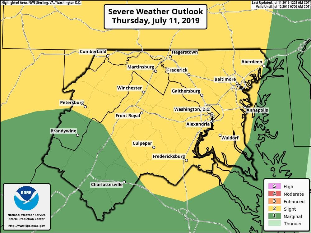
Additionally, a line of showers and storms is approaching from the west. Damaging winds and heavy rainfall, which could lead to flash flooding, are the main threats for the day. The National Weather Service has issued a flash flood watch for parts of the region from 2 p.m. through 2 a.m. Friday. This applies to all or portions of Anne Arundel, Calvert, Carroll, Howard, Montgomery, Charles, Baltimore, Harford, Cecil, Prince George's, and St. Mary's counties.
According to forecasters, showers and thunderstorms are headed our way Thursday evening. "Torrential rainfall may lead to totals exceeding 2 inches in a short period of time. Isolated locations may receive 3 or 4 inches. This may cause flash flooding of small streams and other poor drainage urban areas."
Find out what's happening in Bel Airfor free with the latest updates from Patch.
The Washington Post's Capital Weather Gang doesn't anticipate flooding as severe as Monday's storm. Forecasters call for "very heavy rain over a short period of time resulting in pockets of flash flooding."
A flash flood watch means conditions may develop leading to flash flooding. Residents should monitor forecasts should a flash flood warning be issued. If you encounter a flooded road, "turn around, don't drown."
Find out what's happening in Bel Airfor free with the latest updates from Patch.
In addition to the flash flood watch, a wider range of the region is under a slight risk of severe weather Thursday afternoon. The main concern will be damaging winds into the evening hours.
Here's the current NWS forecast for the Baltimore/DC region:
Thursday: A chance of showers, then showers and thunderstorms likely after noon. Some storms could be severe, with damaging winds and heavy rain. Cloudy, with a high near 87. South wind 6 to 8 mph. Chance of precipitation is 60%. New rainfall amounts between 1 and 2 inches possible.
Thursday Night: Showers and thunderstorms before midnight, then showers likely and possibly a thunderstorm between midnight and 3am, then a slight chance of showers after 3am. Some storms could be severe, with damaging winds and heavy rain. Patchy fog after 3am. Low around 73. South wind 3 to 7 mph. Chance of precipitation is 80%. New rainfall amounts between 1 and 2 inches possible.
Friday: Patchy fog before 9am. Otherwise, mostly sunny, with a high near 89. West wind 5 to 8 mph.
Friday Night: Mostly clear, with a low around 71. Northwest wind 5 to 8 mph becoming calm after midnight.
Saturday: Sunny, with a high near 90. Northwest wind 3 to 6 mph.
Saturday Night: Mostly clear, with a low around 73.
Sunday: Sunny, with a high near 91.
Get more local news delivered straight to your inbox. Sign up for free Patch newsletters and alerts.