Weather
Severe Thunderstorm Warning Expires In 2 Counties
The National Weather Service issued the warning due to a storm in the area.


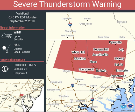
The National Weather Service issued a severe thunderstorm warning for parts of Harford and Baltimore counties. It expired at 7:15 p.m. on Monday, Sept. 2.
Radar detected a severe thunderstorm over Kingsville after 6:30 p.m., officials said. It was moving east at 25 mph, and hazards included 60 mph wind gusts and quarter-sized hail, according to the warning.
These areas may be impacted: Middle River, Bel Air South, Essex, Perry Hall, Rosedale, Rossville, White Marsh, Bowleys Quarters, Kingsville, Pleasant Hills, Perryman, Edgewood, Joppatowne, Nottingham, Fork, Magnolia, Chase, Bradshaw, Abingdon and Joppa.
Find out what's happening in Bel Airfor free with the latest updates from Patch.
During the severe thunderstorm warning period, people should go inside to stay safe to an interior room on the lowest floor. Do not drive underneath wooded areas until the threat has passed, as trees and branches may fall. Roads may become blocked by downed trees, and localized power outages are possible, according to the warning.
Earlier, another thunderstorm prompted a warning. Radar detected a severe thunderstorm 9 miles north of Cockeysville before 6 p.m. that was moving east at 20 mph, officials said. These areas were warned in that case: Cockeysville, Bel Air South, Bel Air North, Fallston, Kingsville, Pleasant Hills, Jarrettsville, Pylesville, Freeland, Cardiff, Norrisville, Bentley Springs, Forest Hill, Phoenix, Street, Jacksonville, Butler, Monkton, Hickory and Whiteford.
Find out what's happening in Bel Airfor free with the latest updates from Patch.
Get more local news delivered straight to your inbox. Sign up for free Patch newsletters and alerts.