Weather
108-Degree Heat Index In Harford County, Then Storms Forecast
A warning is in effect for Harford County before potentially hazardous storms break the heat, according to the National Weather Service.


HARFORD COUNTY, MD — For the third day in a row, temperatures may feel like they are in the triple digits. The hottest time of day will be at 4 p.m. in Harford County, according to the forecast. There's a chance of showers and thunderstorms Sunday night, but it's the heavy rain and storms coming Monday that will finally break the heat.
Due to the sweltering conditions, the National Weather Service has issued an excessive heat warning for most of Maryland.
The excessive heat warning is in effect from 11 a.m. to 9 p.m. on Sunday, July 21. Dangerously high temperatures and humidity could lead to heat stress or heat stroke, according to the warning.
Find out what's happening in Bel Airfor free with the latest updates from Patch.
The excessive heat warning calls for heat indices of up to 110 degrees; the heat index is what it will feel like outside, when taking humidity into account as well as the actual temperature. Actual temps will range from the high 90s to 100 degrees, according to the forecast.
People should take precautions like wearing lightweight clothing, drinking water, rescheduling strenuous activities to the early morning or evening and taking frequent breaks in the shade or air-conditioning if working outside; and they should not leave children or pets alone in hot cars for any amount of time.
Find out what's happening in Bel Airfor free with the latest updates from Patch.
Here is a look at the forecast for Sunday, July 21, in Harford County:
- 8 a.m. — 85 degrees, feels like 94 degrees
- 9 a.m. — 88 degrees, feels like 99
- 10 a.m. — 91 degrees, feels like 103
- 11 a.m. — 90 degrees, feels like 102
- 12 p.m. — 92 degrees, feels like 105
- 1 p.m. — 93 degrees, feels like 105
- 2 p.m. — 94 degrees, feels like 106
- 3 p.m. — 95 degrees, feels like 107
- 4 p.m. — 96 degrees, feels like 108
- 5 p.m. — 95 degrees, feels like 107
- 6 p.m. — 93 degrees, feels like 105
- 7 p.m. — 91 degrees, feels like 102
- 8 p.m. — 87 degrees, feels like 96
- 9 p.m. — 84 degrees, feels like 92
- 10 p.m. — 82 degrees, feels like 89
- 11 p.m. — 80 degrees, feels like 85
It feels like Havre de Grace has been closer to the Sun during the last few days. During this heatwave drink plenty of water, check on your neighbors, avoid outdoor activities, and call 911 if you see a child or animal in a parked vehicle. pic.twitter.com/xQjcvTKPsq
— HdG Police (@HdGPolice) July 21, 2019
Cooling Centers Open
The Aberdeen and Bel Air branches of Harford County Public Library will open from noon to 5 p.m. on Sunday, July 21, for those who need to cool off.
- Aberdeen branch – 21 Franklin Street, Aberdeen
- Bel Air branch – 100 E. Pennsylvania Avenue, Bel Air
Heat Safety
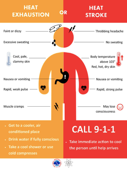
Heat illnesses can take several forms, from heat exhaustion to heat stroke.
The Harford County Department of Emergency Services offers these tips for heat safety:
- Stay indoors as much as possible and limit sun exposure.
- Open your windows and use a fan if you don't have air conditioning.
- Drink plenty of water and avoid strenuous activity.
- Never leave children or pets alone in a closed vehicle.
- Check on elderly neighbors and other vulnerable citizens.
- Keep pets hydrated with access to shelter.
When a person experiences heat stroke, the body is unable to control its temperature and the result can be fatal. People who experience symptoms of heat stroke — throbbing headache, lack of sweating and strong rapid pulse — should get immediate medical attention, according to the Harford County Health Department.
5-Day Forecast In Harford County
Sunday: Mostly sunny, with a high near 96 and heat indices as high as 108. Scattered showers and thunderstorms after 5 p.m. Chance of precipitation is 30%. Low around 74.
A hazardous weather outlook has been issued as storms are forecast Sunday night and Monday that could bring damaging wind gusts and heavy rain that may lead to flooding.
Monday: High near 87 and low of 66. Showers and thunderstorms could produce heavy rain. Chance of precipitation is 90%. New rainfall amounts between three quarters and one inch possible.
Tuesday: Mostly cloudy, with a high near 80 and low of 63. A chance of showers, mainly before noon. Chance of precipitation is 50%.
Wednesday: Mostly sunny, with a high near 81 and low of 62.
Thursday: Sunny, with a high near 83 and low around 64.
Friday: Sunny, with a high near 85 and low around 66.
Saturday: High of 86.
Get more local news delivered straight to your inbox. Sign up for free Patch newsletters and alerts.