Weather
Tornado Confirmed In Maryland: National Weather Service
The National Weather Service confirmed a tornado touched down on Friday, April 26, in central Maryland.

MONKTON, MD — An EF-1 tornado touched down in Monkton on Friday, April 26. After a storm survey, the National Weather Service confirmed the report on Sunday.
An EF-1 tornado is the second weakest tornado after an EF-0 tornado.
The tornado had maximum wind speeds of 90 mph when it arrived Friday afternoon.
Find out what's happening in Bel Airfor free with the latest updates from Patch.
During its time on the ground, the tornado traveled 3 miles and was 150 yards wide.
It was in the area from 3:19 to 3:23 p.m. and traveled from northeastern Baltimore County to northwestern Harford County, according to the report.
Find out what's happening in Bel Airfor free with the latest updates from Patch.
While there were no injuries, the National Weather Service said there were more than a dozen trees damaged and in one case, damage to a playground structure.
The Path Of The Tornado
The tornado began on Corbett Road between Monkton Farms Drive and Falls Road and ended near the intersection of Shepperd Road and Troyer Road, weather officials reported.
As the storm moved northeast, there was "sporadic tree damage" from straight line winds along a path from northeastern Baltimore County to northwestern Harford County, the report said.
Multiple trees on Corbett Road snapped, with leaf and branch debris in the area too.
Moving northeast, the tornado reached the 2400 block of Monkton Road at 3:20 p.m., according to the radar. Seven trees fell in the area, officials said, and there were multiple tree limbs down.
At least 10 trees snapped along a 150-yard path along Shepperd Road about a minute later, weather officials reported. Some trees snapped closer to the base, while others had their tops snapped off.
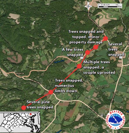
Two screens were blown in at a property where there was a horse barn, and the wind also tore off a slide from a playground and threw it to the northwest, according to authorities.
Due to the intermittent damage and little structural damage, authorities said that the winds were expected to have been 80 to 90 mph. Once winds exceed that speed, officials say more sturdy structures would have been damaged.
Did you see any storm damage? Tell us in the comments!
Graphic of the tornado's path courtesy of the National Weather Service.
Get more local news delivered straight to your inbox. Sign up for free Patch newsletters and alerts.