Weather
Winter Weather In MD Forecast: National Weather Service
Wintry weather will return soon, according to the National Weather Service, which shows snow, sleet and freezing rain in the forecast.


MARYLAND — Maryland may see the return of wintry weather in the next few days. Snow, sleet and freezing rain are likely overnight Sunday into Monday after a chilly couple of days.
Highs are in the mid 30s on Saturday and Sunday, but it may feel like the 20s due to wind chills, according to the forecast from the National Weather Service.
Once the chill settles in, snow may materialize overnight Sunday into Monday morning.
Find out what's happening in Bel Airfor free with the latest updates from Patch.
Snow is most likely to arrive in the early hours on Monday, with a wintry mix of snow, sleet and freezing rain continuing through the day, based on the current projections.
Forecast Includes Snow, Sleet, Rain
Saturday: Sunny, with a high near 35 and low around 23. Northwest wind 9 to 13 mph, with gusts as high as 24 mph.
Find out what's happening in Bel Airfor free with the latest updates from Patch.
Sunday: Increasing clouds, with a high near 36 and low of 32. Calm wind becoming south around 6 mph in the afternoon.
Monday: Snow likely before 4 a.m., then snow, freezing rain and sleet likely. Cloudy, with a high near 37 and low of 32. Light south wind. Chance of precipitation is 70%. Little or no ice accumulation expected. New snow and sleet accumulation of less than one inch possible.
Tuesday: Rain. High near 44 and low of 36. Chance of precipitation is 100%.
Wednesday: Mostly sunny, with a high near 46 and low around 30.
Image via Shutterstock.
PREVIOUS REPORT: This week's springlike weather was not going to last, and forecasters say that Maryland may see the return of wintry weather in the next few days. The National Weather Service has issued a hazardous weather outlook due to its increasing confidence that wintry precipitation will hit central Maryland Sunday through Tuesday, including Baltimore City and Anne Arundel, Baltimore, Carroll, Frederick, Harford, Howard, Montgomery and Prince George's counties.
First, brace yourself for the winds.
There were gusts of 51 mph reported at the Key Bridge after 3 p.m. on Friday, Feb. 8.
The Key Bridge is under limited wind restrictions, the Maryland Transportation Authority reported. During limited wind restrictions, winds are greater than 40 mph and house trailers, empty box trailers or any vehicle law enforcement officers think may not safely cross are prohibited from traveling on the bridge. Drivers denied passage will be assisted with turning around.
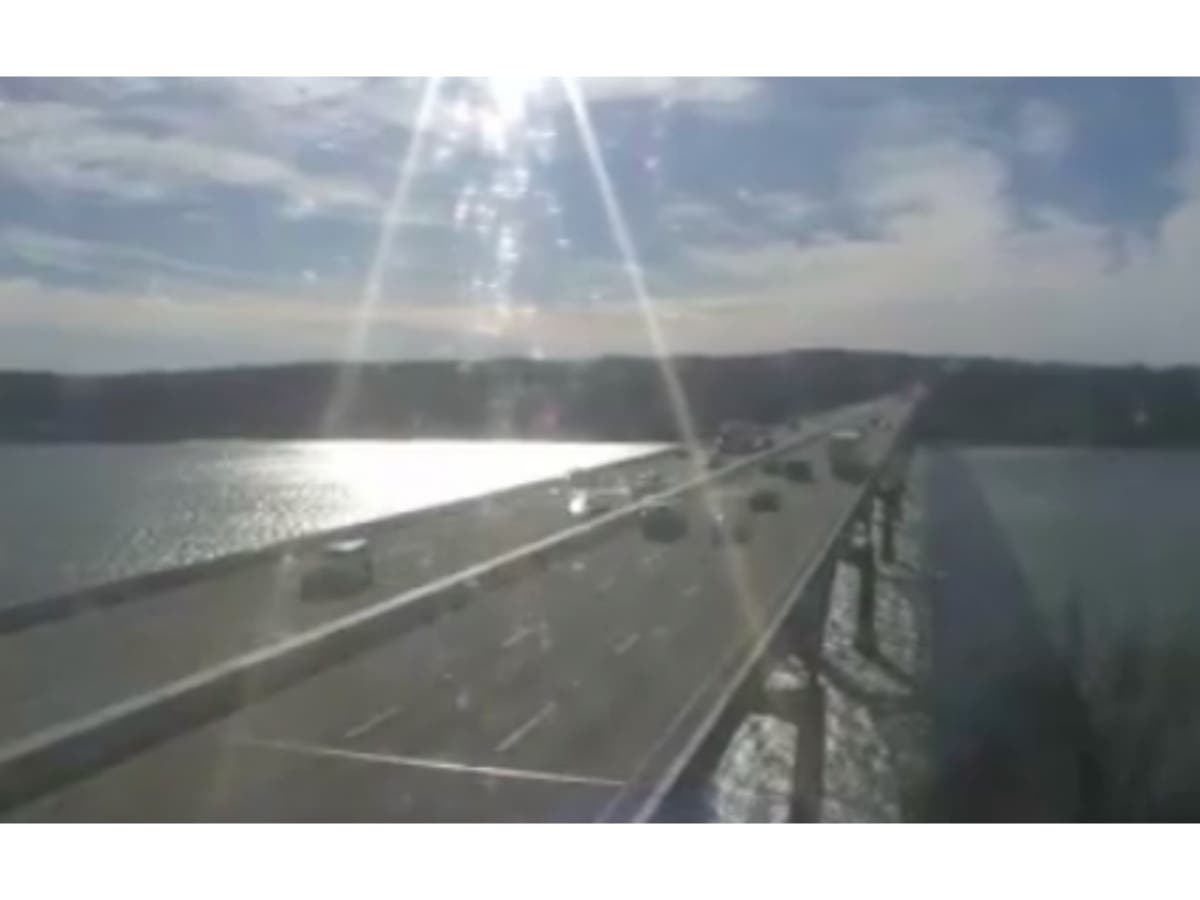
Wind warnings are in effect on the Hatem and Tydings bridges, authorities said.
Wind warnings are issued when winds are 30 to 39 mph. Drivers of the following should use extra caution crossing bridges during wind warnings: house trailers, box trailers, motorcycles, vehicles with cargo on roof racks and any other vehicles subject to high winds.
BRIDGESTATUS: Limited restrictions at I-695 Key Bridge (no house or empty box trailers). Warnings at Bay, US 40 Hatem & I-95 Tydings bridges. Both hands or paws on the steering wheel. Policy detailed here https://t.co/UuSaI93qps #mdtraffic #baltraffic #FurryFriday pic.twitter.com/mVDnCLRtAz
— MDTA (@TheMDTA) February 8, 2019
A gale warning is in effect on the Chesapeake Bay and Potomac River until 6 p.m. on Friday, Feb. 8, due to winds from 34 to 47 knots.
A small craft advisory is in effect from 6 p.m. Friday to 6 p.m. Saturday, calling for 18 to 33 knots.
Temps To Drop Friday: Code Blue, Warming Centers
Temperatures may drop more than 30 degrees from Friday afternoon to Friday evening.
The forecast shows daytime temps in the 50s on Friday, with a low in the low 20s overnight.
Saturday's high is in the low 30s, but it may feel like 19 degrees due to wind chills, according to the forecast from the National Weather Service.
From Saturday to Sunday, wind chills may be in the teens and even single digits.
Interim Health Commissioner Mary Beth Haller has issued a code blue declaration for Baltimore City from Friday night through Saturday morning.
“With much colder temperatures expected overnight following a week of warmer weather, I am issuing a Code Blue Extreme Cold declaration beginning tonight through Saturday morning. I encourage residents to stay indoors, especially those most vulnerable to cold,” Haller said in a statement on Friday, Feb. 8. “Extreme cold temperatures can permanently injure, or even kill. Please be sure to check on neighbors who you think may be at risk to ensure that they have heat and power, and take care to shelter pets appropriately.”
Anne Arundel County will open warming centers from Saturday, Feb. 9, until Monday, Feb. 11.
With Wintry Weather On Way
"Confidence has increased regarding the threat for wintry precipitation Sunday night into Monday, and again Monday into Tuesday," according to a statement issued by the National Weather Service Friday afternoon.
"The best chance for a prolonged period of wintry precipitation will be across northern Maryland and for locations near and west of the Blue Ridge and Catoctin Mountains," according to a hazardous weather outlook. "If the threats materialize, it may cause travel disruptions."
Snow is most likely to arrive in the early hours on Monday, with a wintry mix of snow, sleet and freezing rain continuing until noon on Tuesday, based on the current projections.
Forecast Includes Snow, Sleet, Rain
Here's the forecast from the National Weather Service from Friday, Feb. 8, to Wednesday, Feb. 13:
Friday: Sunny, with a high near 54. Breezy, with a west wind around 22 mph, with gusts as high as 39 mph. Overnight low around 21.
Saturday: Sunny, with a high near 33 and low of 19. Northwest wind 10 to 17 mph, with gusts as high as 25 mph. Wind chills may make it feel like single digits around 7 a.m.
Sunday: Mostly sunny, with a high near 38 and a low of 29. Calm wind becoming south 5 to 7 mph in the morning.
Monday: A chance of snow before 1 a.m., then snow, freezing rain and sleet likely. Chance of precipitation is 60%. High of 38 and low of 28.
Tuesday: Snow, freezing rain, and sleet before noon, then rain. High near 39 and low of 33. Chance of precipitation is 80%.
Wednesday: Mostly sunny, with a high near 45 and low of 26.
Pictured, Tydings Bridge on Feb. 8. The bridge is under a wind warning, as winds were gusting at 34 mph as of 2:45 p.m., according to state transportation data. Photo courtesy of CHART.
Get more local news delivered straight to your inbox. Sign up for free Patch newsletters and alerts.