Weather
'This Is Going To Be A Dangerous Storm': Maryland Governor
Maryland Gov. Larry Hogan and the State Highway Administration urge travelers to prepare for heavy snow in the forecast Wednesday.


MARYLAND — With heavy snow in the forecast across the Baltimore-Washington region, the National Weather Service has issued winter storm warnings because travel may be very difficult on Wednesday, Feb. 20. In fact, the governor and state highway crews are urging people to avoid traveling during Wednesday's snowstorm if possible.
"This is going to be a dangerous storm," Maryland Governor Larry Hogan said at a Tuesday afternoon press conference. "The number one thing that we ought to be planning on is not driving during rush hour tomorrow."
Between 7 and 11 a.m. on Wednesday, Hogan said between 6 and 8 inches of snow could fall along the Interstate 95 corridor.
Find out what's happening in Bel Airfor free with the latest updates from Patch.
"We want to encourage you if possible to stay home tomorrow while we clean up these roads," he said, "and if you've got to go to work, make sure that you can go in late after the rush hour and after the worst of the snowfall."
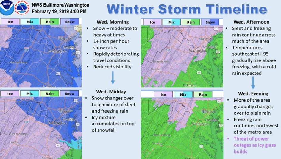
The heaviest snow will most likely fall in bursts during the morning rush hour, forecasters say.
Find out what's happening in Bel Airfor free with the latest updates from Patch.
"The rate of snowfall will be double the rate of the ability of the plows to clear, which will result in snow-covered roadways," according to the Maryland State Highway Administration. "Heavy snowfall will reduce visibility and create hazardous driving conditions. Motorists are urged to make smart travel decisions and, if possible, to curtail driving until the storm passes."
Snow in the morning will mix with and change to sleet and freezing rain by early afternoon, then rain Wednesday night, according to the National Weather Service.
Up to 8 inches of snow could fall in parts of the state, around Frederick, Allegany and Washington counties by Thursday morning, the National Weather Service warns.
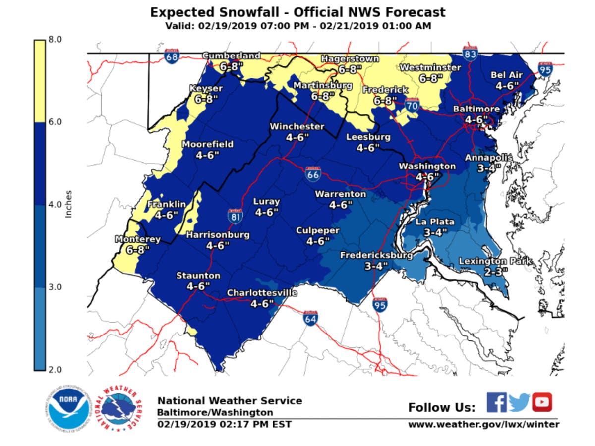
About 4 to 6 inches of heavy snow and 0.1 inch ice are in the forecast Wednesday for central Maryland, including Anne Arundel, Baltimore, Carroll, Harford, Howard, Montgomery and Prince George's counties.
Here are the weather alerts that take effect on Wednesday, Feb. 20:
- 1 a.m. to 7 p.m. —Howard, Montgomery and Prince George's counties are under a winter storm warning for 3 to 6 inches of snow and up to 0.1 inch ice.
- 4 a.m. to 7 p.m. — Anne Arundel, Baltimore, Carroll and Harford counties are under a winter storm warning for 3 to 6 inches of snow and up to 0.1 inch ice.
- 1 a.m. Wednesday to 1 a.m. Thursday — Allegany, Frederick and Washington counties are under a winter storm warning for 4 to 7 inches of snow and up to 0.2 inch ice.
- 7 a.m. to 4 p.m. — Cecil and Kent counties are under a winter storm warning calling for 3 to 5 inches of snow and a glaze of ice.
A winter storm warning means snow, sleet and ice could make travel very difficult or impossible, according to the National Weather Service.
Travel could be very challenging, particularly during the morning and evening commutes, due to slippery road conditions, weather officials said.
Since the storm is projected to produce 6 or more inches of snow, state highway officials will have park and rides available for shelter for truckers and will deploy heavy-duty wreckers in strategic locations near steep grades in case such vehicles become disabled.
Snow melt may lead to localized flooding through the weekend, according to a hazardous weather outlook from the National Weather Service.
PREVIOUS REPORT (EXPIRED): Several inches of snow could be headed our way between Tuesday night and Wednesday evening. The National Weather Service has issued a winter storm watch for much of Maryland as a low-pressure system approaches the region.
A winter storm watch means there is "potential for significant snow, sleet or ice accumulations that may impact travel," according to the weather service.
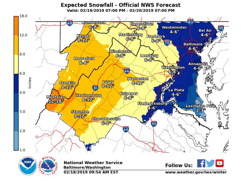
At least 5 inches of snow and 0.25 inch ice are in the forecast between Tuesday and Wednesday nights, according to the winter storm watch.
Heavy snow will mix with and then change to sleet and freezing rain during the watch period, according to the National Weather Service.
The snow is likely to hit Maryland Wednesday morning, as forecasters say the precipitation will develop from southwest to northeast.
The transition from snow to sleet to freezing rain to rain will likely occur midday on Wednesday, according to the National Weather Service's forecast discussion.
"There is the potential for a significant snowfall prior to the changeover," weather officials said. "Then, as temperatures warm aloft and cold air is trapped at the surface, a period of accumulating freezing rain will follow."
The winter storm watch is effective from 10 p.m. on Tuesday, Feb. 19, to 10 p.m. on Wednesday, Feb. 20. Allegany, Anne Arundel, Baltimore, Carroll, Frederick, Harford, Howard, Montgomery, Prince George's and Washington counties as well as Baltimore City and DC are under the winter storm watch.
The Eastern Shore may see 2 to 4 inches of heavy snow, according to the National Weather Service. Caroline, Cecil, Kent, Queen Anne's and Talbot counties are under a separate winter storm watch from 6 a.m. to 7 p.m. on Wednesday, Aug. 20.
Travel could be very difficult across the state, according to a hazardous weather outlook, particularly during the morning or evening commute.
In addition to Maryland, the eastern panhandle of West Virginia as well as central and northern Virginia are under the winter storm watch through Wednesday night.
First, Windy Conditions On Monday
Before the wintry weather hits, winds have prompted a gale warning and small craft advisory for those on Maryland waters.
The gale warning is in effect until 6 p.m. on Monday, Feb. 18. It calls for winds from 34 to 47 knots along the Chesapeake Bay and tidal Potomac. During gale conditions, recreational boaters should seek safe harbor, officials warn.
A small craft advisory is in effect from 6 p.m. Monday to midnight. The advisory means winds from 18 to 33 knots are imminent or occurring, and those in smaller vessels should not be on the water.
Stay up to date on the latest. Get news alerts from Maryland Patches.
Graphic courtesy of the National Weather Service.
Get more local news delivered straight to your inbox. Sign up for free Patch newsletters and alerts.