Weather
2 Rounds Of Snow Forecast For MD This Week: See Details
Another Arctic blast of cold is headed to Maryland, and there are two chances for snow this week, according to the latest forecast.

Two more rounds of snow are possible across Maryland this week, according to the latest forecast, as a frigid stretch continues to hamper work to clear roads and driveways from the late January snowstorm.
The first chance of snow is Tuesday night into Wednesday, according to the National Weather Service. A coating to less than an inch of snow is expected.
"A brief warmup is expected through Tuesday. A clipper-type system will bring a chance of light snow Tuesday night," the NWS said. "Turning colder for the middle and second half of the week. An Arctic front will cross the area Friday night bringing snow showers and sharply colder temperatures for the weekend
Find out what's happening in Bowiefor free with the latest updates from Patch.
The next chance of snow comes Friday as a strong clipper system ahead of an Arctic front passes through the state, National Weather Service forecasters said.
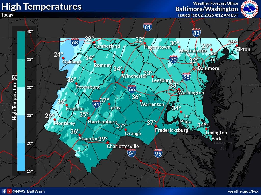
Parts of southern Maryland and Northern Virginia should creep above freezing on Monday, but it won't last long, forecasters said.
Find out what's happening in Bowiefor free with the latest updates from Patch.
"Sunny and not as cold today with high temperatures climbing above the freezing mark for many for the first time in more than a week," the agency said.
Some light snow is possible Wednesday morning, with a light accumulation of a coating to an inch or so possible. Any snow should end by midday, The Washington Post's Capital Weather Gang predicts.
"Clouds increase on Friday, when it’s not as cold. Highs reach the mid-30s or so and a few snow showers or flurries can’t be ruled out," the Post said. "We’re back into the deep freeze over the weekend, with highs only in the 20s and lows in the single digits to near 10 degrees. … Milder air does look like it will return the following week."
Residents across the DMV have found it difficult to dig out their driveways and sidewalks, while many residential streets, school drives and bus stops are still coated with ice. That has lead to a second week of either canceled classes or late starts.
Anne Arundel County Public Schools and Howard County Public Schools both opened two hours late Monday and plan to do the same on Tuesday.
Schools were closed Monday for Montgomery County Public Schools and Prince George's County Public Schools.
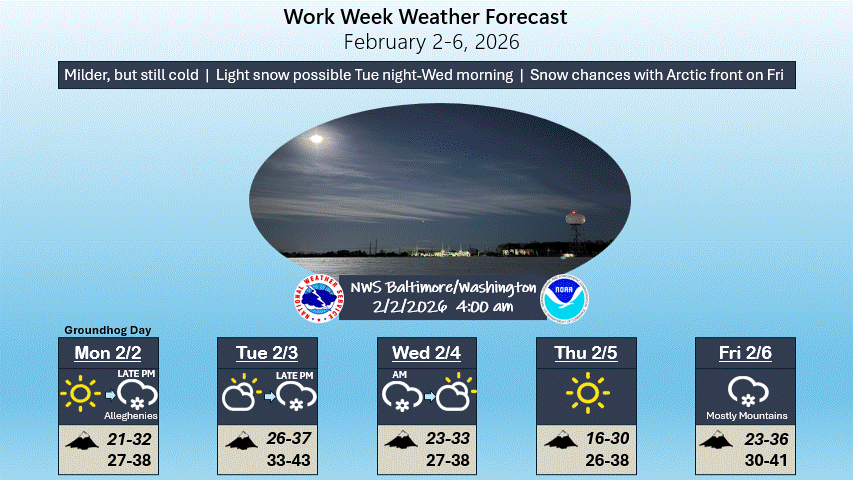
Here's the latest Maryland forecast from the National Weather Service:
Monday Afternoon
Sunny, with a high near 32. West wind 6 to 11 mph, with gusts as high as 18 mph.
Monday Night
Partly cloudy, with a low around 19. Calm wind.
Tuesday
A slight chance of rain and snow after 4pm. Increasing clouds, with a high near 39. Calm wind becoming southwest around 5 mph. Chance of precipitation is 20%.
Tuesday Night
Snow likely, mainly before 1am. Cloudy, with a low around 26. Calm wind. Chance of precipitation is 60%. New snow accumulation of less than one inch possible.
Wednesday
Mostly sunny, with a high near 32. North wind 5 to 7 mph.
Wednesday Night
Partly cloudy, with a low around 17.
Thursday
Sunny, with a high near 28.
Thursday Night
Partly cloudy, with a low around 16.
Friday
A chance of snow. Mostly cloudy, with a high near 33. Chance of precipitation is 50%.
Friday Night
Partly cloudy, with a low around 15.
Saturday
Sunny, with a high near 21. Blustery.
Saturday Night
Mostly clear, with a low around 11.
Sunday
Mostly sunny, with a high near 24.
Get more local news delivered straight to your inbox. Sign up for free Patch newsletters and alerts.