Health & Fitness
The WB&A Trail Saga: The Land Records Speak
Residents and trail advocates have been arguing about whether the County or the Meyers own the WB&A right of way near the Patuxent River. Here's what the land records say.

In the long-running saga on whether to extend the WB&A Trail into Prince George's County or build a detour suggested by the late Buz Meyer, people often bolster their case by talking about who owns the right of way.
Advocates for extending the WB&A Trail have been saying since the 1990s that Anne Arundel County owns the entire right of way. Those who favor the Buz Meyer detour have been saying for just as long that Buz Meyer and his brothers owned the WB&A right-of-way along their 177-acre parcel between Meyers Station Road and the Patuxent River. I previously suggested that both have a claim, and that the State of Maryland should pay the Meyers $1 million or so to resolve the matter.
Anne Arundel County land records tell a different story. I'll summarize here. You can find my complete report of the WB&A/Meyers land title story on the Washcycle blog (complete with footnotes).
Find out what's happening in Odenton-Severnfor free with the latest updates from Patch.
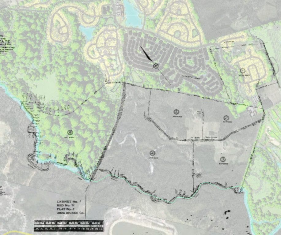
The story is typical, at first. Jacob Meyer (1958-1926) and Bertha Meyer (1859-1940) bought a 600-acre farm along the Patuxent River in 1900, which the Swiss embassy previously used as a retreat. A year later, they sold a right of way to the Washington and Annapolis Electric Railway. They subdivided their farm into 6 parcels and gave one to each of their children. But none of the parcels included the land under the railroad! Their wills didn’t mention that land, and I doubt that the wills of their children mentioned it either. So the ownership has gradually become “fractionated”. (I have uploaded a copy of the original subdivision plat created by Jacob Meyer, as well as the site plan for the Preserve at Two Rivers with those parcels overlaid.)
The family seems to have gradually forgotten that they still owned the land under the tracks. As long as the railroad was still running, it did not matter. But in 1935, the WB&A Electric Railway went bankrupt after the state decided that that the railroad would no longer be exempt from property taxes. The tracks were removed and mostly scrapped (although two rails support the main floor of my house.) In 1936, the Pennsylvania Railroad bought the right of way. In 1988, the bankrupt Penn Central sold the right of way to Peppercorn Realty. After building Piney Orchard, Peppercorn Realty conveyed the right of way to Anne Arundel County for $10.
Find out what's happening in Odenton-Severnfor free with the latest updates from Patch.
Anne Arundel County understood that it was not buying clear title to the land. The deed was called a “quitclaim deed” with all sorts of disclaimers. But that had not stopped the County from building the B&A Trail (from Glen Burnie to Arnold). This is a fairly standard practice: Localities build rail trails on land for which they do not have clear title, because the actual owners have abandoned their interest, as it fractionated over the decades. Neither the common law nor common sense wants property tied up forever just because it is technically owned by the descendants of an original owner, when those descendants are uninterested in the land. Especially when those owners are not paying property taxes. In the rare case when these owners do step forward, the locality pays them for their property.
But in this case, there was a surprise ending: The Meyers opposed the trail, and they could point to the 1901 deed. They launched a successful effort to persuade County Executive Janet Owens to stop the WB&A trail and drop the court proceedings the county had initiated to resolve the ownership issues. Interestingly, the Maryland Department of Assessments and Taxation still assumes that the County owns this land. The part of the roadbed through the wetlands is easily worth $1-2 million dollars. If properly calculated, the taxes will be significant (but still only a small fraction of the taxes on the rest of the parcels we have been discussing).
So who really owns that right of way? To identify all the owners, we would need the complete family tree showing all descendants of Jacob and Bertha Meyer, as well as all of the heirs of their children, some of whom may be in-laws.
The divided ownership could be a foundation for a compromise trail alignment. The obvious compromise option is for the trail to cross at the site of the original bridge over the Patuxent River, which would save a few million dollars and is remote from most activities on the Meyers’ land. The trail could then take a reasonable detour that keeps the trail far enough from the Meyers’ property to satisfy 80 percent of their concerns, while avoiding the steep hill that makes the planned detour inappropriate for a rail trail. If the Meyers own a majority—but not all—of the railbed, then the owners might negotiate a partition of the property along these lines.
Note about the maps: If you use Google Maps to look at these parcels, it erroneously shows Lot 6 as a county-owned park called Patuxent River Park. Old USGS quadrangle maps also denote a Patuxent River Park there, albeit without any boundaries. I do not know the source of this error. However, a 1915 deed from the Meyers to the WB&A Railroad did convey 0.6 acres along the railroad in fee simple, which the county acquired from Peppercorn in 1995. Technically, the county does have an easement by necessity to access that parcel, if it wanted a park there. Such a park is unlikely.
Note from Odenton Patch editor Tim Lemke: We've been doing some separate reporting on the issue of the completion of the WB&A Trail and hope to have a report shortly. We spoke with Rick Anthony, director of Anne Arundel County Recreation and Parks on Thursday, and he said the county essentially views the land as being owned by the Meyer family, and has no plans to build on it or pursue a claim for it.