Weather
Winter Weather Advisories Issued Across Maryland
Snow, sleet and freezing rain could fall in the days ahead, the National Weather Service advises.


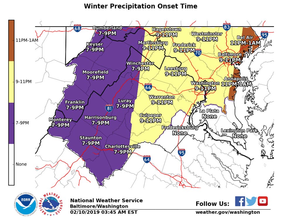
MARYLAND — A mix of snow, sleet and freezing rain may fall Sunday night and Monday morning, prompting the National Weather Service to issue winter weather advisories around the state. Wintry weather is expected to begin Sunday night across Maryland, sticking around long enough to snarl the Monday morning commute.
The wintry mix of snow, sleet and freezing rain will likely taper off by 10 a.m. Monday in central Maryland, northern Virginia and DC, according to the National Weather Service.
Another round of wintry weather may develop Monday night, potentially causing problems Tuesday morning as well, the weather service advised.
Find out what's happening in Perryvillefor free with the latest updates from Patch.
Roads may be slick, with limited visibility.
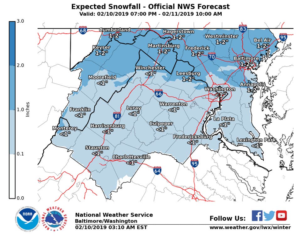
About 1 to 2 inches of snow and less than 0.1 inch ice are expected in central, northern and western Maryland Sunday night to Monday morning, according to the winter weather advisory.
Find out what's happening in Perryvillefor free with the latest updates from Patch.
Baltimore City and Allegany, Anne Arundel, Baltimore, Carroll, Frederick, Harford, Howard and Montgomery counties are under this advisory, effective from 7 p.m. on Sunday, Feb. 10, to 10 a.m. on Monday, Feb. 11.
During the advisory period, drivers should be extra careful, as snow, sleet and freezing rain could make roads slippery and cause travel complications.
Less snow is expected close to the nation's capital. Prince George's County and the District of Columbia are under a separate winter weather advisory, calling for up to 1 inch of snow and 0.1 inch ice from 7 p.m. Sunday to 10 a.m. Monday.
In Cecil County, the winter weather advisory lasts a bit later on Monday. The advisory there is in effect from 10 p.m. Sunday to noon Monday. About 2 inches of snow are in the forecast, which could be locally higher in some areas, the advisory states. A light glaze of ice is also possible.
The advisory for Cecil County also applies to central and northern Delaware and parts of southern New Jersey and southeast Pennsylvania. North of Delmarva will likely get snow, while southern areas may get snow, sleet and freezing rain, according to the weather service.
The winter weather does not end Monday.
Snow, sleet and freezing rain could continue Monday night, turning to rain Tuesday morning, affecting Tuesday's commute as well, the National Weather Service advised.
A winter storm watch is in effect from 4 p.m. Monday to 10 a.m. Tuesday for northern Baltimore, Carroll, Frederick and Harford counties calling for more snow. Weather officials issue a winter storm watch when there is potential for significant snow, sleet or ice accumulations that may impact travel.
"There is the potential for 5 or more inches of snow and additional freezing rain Monday night into Tuesday, especially near the Pennsylvania border," the watch states.
It issued a hazardous weather outlook, stating that localized flooding may occur Tuesday due to the potential for heavy rain.
Maryland Transportation Officials Prepare
Roads have been pre-treated throughout the state, the Maryland Department of Transportation said in a statement Sunday morning. (Use MDOT's storm tracker to see roads that have been treated.)
The agency said it was preparing for a "two-part storm" that moves west to east, leaving the highest accumulations on the northern and western tiers of the state.
"Areas of mixed precipitation will affect most of central Maryland, especially during the Tuesday morning commute, where conditions may deteriorate before warmer air reaches the state," the Maryland Department of Transportation's State Highway Administration advised.
Drivers should take it slow on ice and snow, remembering speed limits are designed for dry conditions; and they should allow for extra time during their commutes.
Bridges, ramps and overpasses freeze first, so use extra caution on those.
Shifting Temperatures
Temperatures will be in the 30s on Sunday, with a high near 38 degrees and a low of 31.
Monday will bring a high near 36 and a low of 31 degrees.
Tuesday's high is near 39 degrees with a low of 35.
Wednesday temps will rise a bit, with a high around 46 degrees and low of 31.
Thursday's high is 51 degrees with a low around 40, according to the forecast.
Graphics via National Weather Service.
Get more local news delivered straight to your inbox. Sign up for free Patch newsletters and alerts.