Weather
50s To Flurries In MA: Warm Front Moves In, Precipitation To Follow
The warmer-than-usual temperatures come with snow possible this weekend, according to forecasts.

MASSACHUSETTS — Warm temperatures will overspread the region beginning Tuesday and peaking on Wednesday — but the mild weather may lead to snow later this week, according to the National Weather Service.
Temperatures will reach into the upper 50s in most spots across Massachusetts on Wednesday, and in the low 50s on both Tuesday and Thursday.
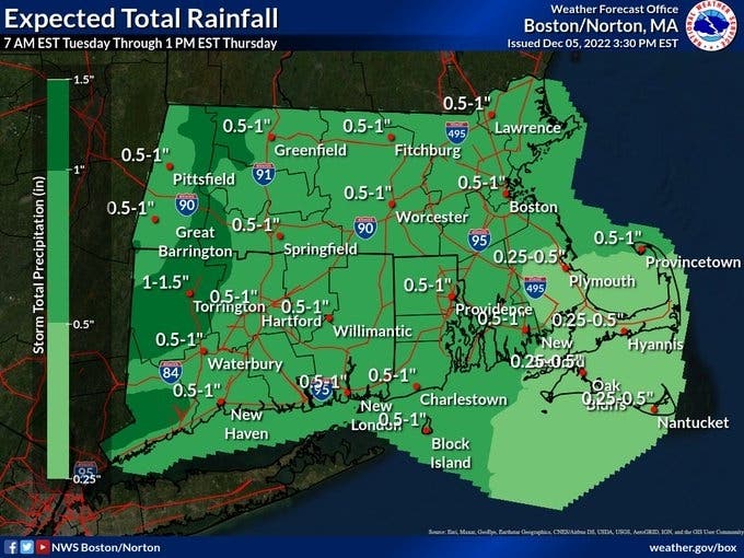
That warm air will also bring rain showers beginning Tuesday night and continuing through Thursday. The entire state from Boston to Springfield could end up with up to 1 inch of rain.
Find out what's happening in Across Massachusettsfor free with the latest updates from Patch.
Precipitation will continue through the weekend as daytime temperatures cool into the 30s in some parts of the state — setting up the chance for a little now.
"Seasonably mild conditions come to an end late in the week. Unsettled, low confidence forecast this weekend as a complex mid-level pattern sets up. Anticipating a chance for showers and flurries over the weekend," the weather service said in a Tuesday morning forecast.
Find out what's happening in Across Massachusettsfor free with the latest updates from Patch.
Here how warm temperatures will get before the weekend cool down:
| Tuesday | Wednesday | Thursday | |
| Boston | 53 | 55 | 53 |
| Gloucester | 52 | 54 | 53 |
| Hyannis | 53 | 56 | 53 |
| Lowell | 53 | 53 | 52 |
| Nantucket | 53 | 56 | 54 |
| New Bedford | 54 | 56 | 56 |
| Springfield | 53 | 56 | 53 |
| Worcester | 51 | 53 | 51 |
Get more local news delivered straight to your inbox. Sign up for free Patch newsletters and alerts.