Weather
Damaging MA Winds, Frigid Temperatures Follow Springlike Start To Week
A dose of winter and potentially hazardous winds is due this week before the unseasonable warmth rushes back in for the weekend.

MASSACHUSETTS — A return — and perhaps last gasp? — of winter will follow the unseasonably warm start to the week across Massachusetts with heavy rain, potentially damaging wind and a day of frigid wind chills moving into the region.
Tuesday's bright sunshine and temperatures near 60 degrees will turn to rain Tuesday night and early Wednesday as a storm and cold front approaches. The National Weather Service has issued a Wind Advisory for eastern Massachusetts, Cape Cod and interior southeastern Massachusetts for Wednesday into Thursday as winds ramp up along coastal locations on Wednesday and spread through the entire state on Thursday.
(Also on Patch: As El Niño Falls Apart, Spring May Come Early To MA)
Find out what's happening in Across Massachusettsfor free with the latest updates from Patch.
"Winds could gust up to 55 to 65 miles per hour initially from the south, then turning northwest," the National Weather Service said on Tuesday morning. "Heavy rain and high winds will lead to hazardous travel Wednesday night."
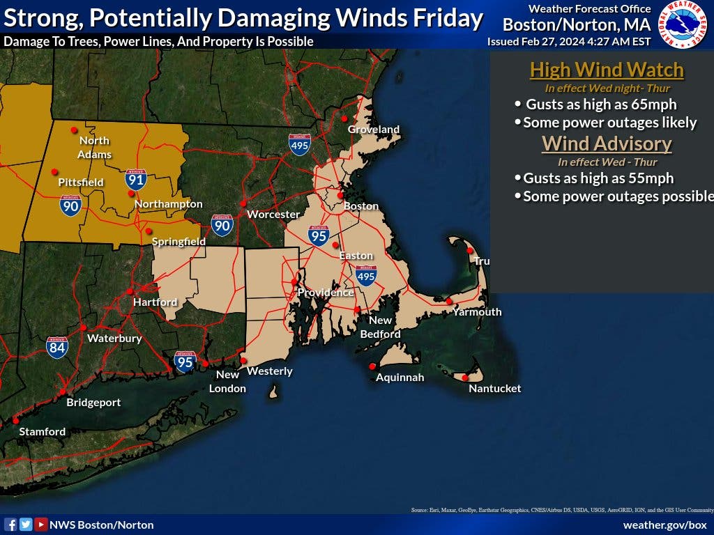
Peak gusts are forecast to be as high as 55 mph on Nantucket, 54 mph in Hyannis, 52 mph in Provincetown, 47 mph in Boston and 47 mph in Worcester.
Find out what's happening in Across Massachusettsfor free with the latest updates from Patch.
The potential for wind damage is greatest for the Cape and coastal locations throughout the bulk of Wednesday's storm but will be more widespread across the region Thursday as temperatures fall back into the 20s and 30s with wind chills making it feel like the teens most of the day.
The bitter blast should be short-lived, however, with temperatures rebounding back into the upper 40s on Friday and then well into the 50s on Saturday and Sunday.
That will continue the trend of above-normal to well-above-normal temperatures into the first two weeks of March when occasional cooldowns are expected to be followed by warm spikes with high temperatures in the 50s to near 60 degrees throughout next week.
(Scott Souza is a Patch field editor covering Beverly, Danvers, Marblehead, Peabody, Salem and Swampscott. He can be reached at Scott.Souza@Patch.com. X/Twitter: @Scott_Souza.)
Get more local news delivered straight to your inbox. Sign up for free Patch newsletters and alerts.