Weather
MA Braces For First Big Snow Of The Season: How Much Could We Get?
Forecasts are starting to come into focus on potential totals from the Saturday night and Sunday storm.


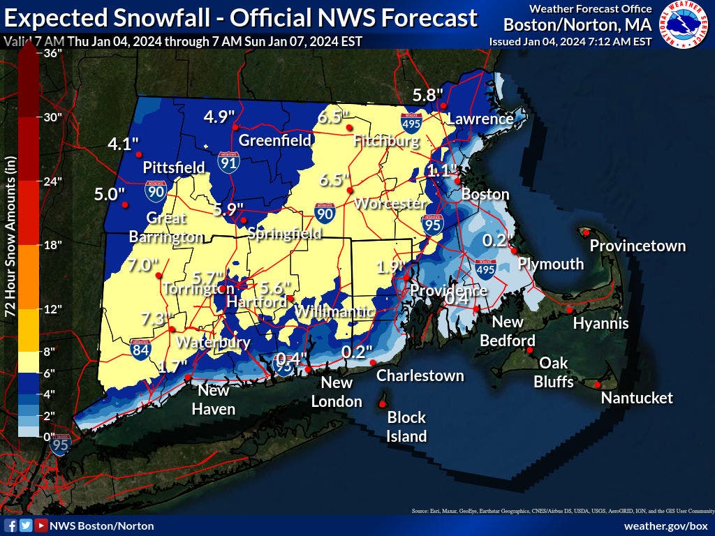
MASSACHUSETTS — It appears there is increasingly little chance of escaping the first significant snowfall of the season for most of Massachusetts this weekend with snow total forecasts now predicting 6.5 inches or more for much of the state.
The National Weather Service posted its first snowfall map on Thursday morning with a wide swath of interior Massachusetts and southern New England in the 6-inch-or-more range.
There is a chance that there will be mixing along the coast — especially on Cape Cod where there could be little to no accumulation.
Find out what's happening in Across Massachusettsfor free with the latest updates from Patch.
The biggest question ahead of the weekend will be coastal and immediate inland locations where the warm ocean water could limit the accumulation to 3 inches or less, or where there could be larger totals more in line with the rest of the state if the storm track wobbles just a little farther east.
Most areas west of Route 95/128 were in the mostly-snow range as of Thursday morning.
Find out what's happening in Across Massachusettsfor free with the latest updates from Patch.
The National Weather Service on Thursday said snow is expected to arrive later Saturday night into early Sunday morning with heavy precipitation beginning after 2 a.m.
Snow will continue throughout most of Sunday with the heaviest weather coming through the morning and early afternoon.
An easterly wind will switch around to the north and gust up to 30 miles per hour — though this is not expected to be as major of a wind-damage event as recent rain storms and harsh nor'easters.
Areas that do get rain overnight on Saturday should all turn to snow later on Sunday before the storm winds down late in the day.
Check back with Patch for storm updates throughout the week and any event cancellations, snow emergency parking restrictions or other advisories.
Get more local news delivered straight to your inbox. Sign up for free Patch newsletters and alerts.